Colorado weather: Saturday snow exits, chilly temps linger on Sunday

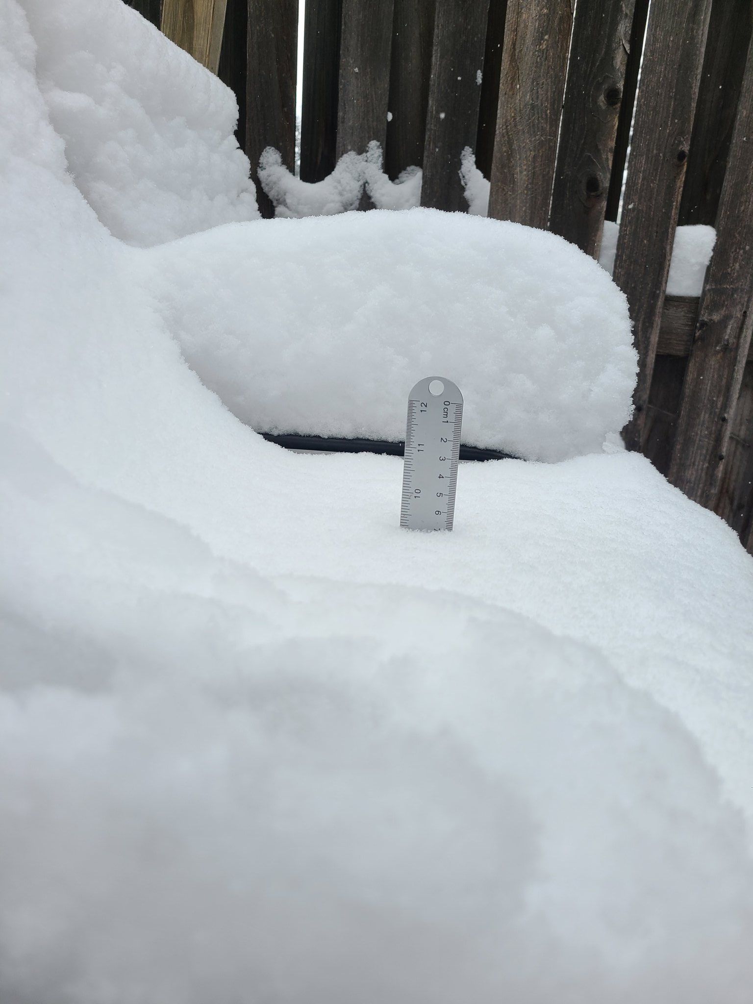
So, for the most part, the forecast held with most folks down low managing 1-4", and the northern foothills and Front Range saw anywhere between 5-10". Daniel from Fort Collins measured close to double digit snow around lunch time on Saturday.
Close to 10 inches on the chair here in the Red Fox Meadows area. Lovely fluffy snow. #cowx #fortcollins @NWSBoulder @HighpointWx @weather5280 @BoulderCAST https://t.co/gWe5eXNwtD pic.twitter.com/L4WR2h1phY
— Daniel Amerman (@QuirkyGardener) November 25, 2023
In our previous update we had mentioned the potential for lower-end totals during the Thursday night and Friday snow. That was bolstered a bit this morning by our old friend, the "Denver Cyclone". It's a feature that frequently affects weather around northeast Colorado.
just denver cyclone things pic.twitter.com/QgWvn76yQM
— Luke Victor 🌨️🌨️📈 (@LukeVictorWx) November 25, 2023
Early this morning, a broad surface circulation developed northwest of downtown Denver, and moved east along I-70. That little feature managed to drop an extra 0.05-0.25" of liquid, and when you consider our 25-30:1 snowfall ratios brought an additional 1-5" of fresh snow this morning.
This circulation is also pretty visible from the National Weather Service in Boulder's post too: check it out on radar
Snow will continue over eastern Larimer & Weld counties through noon, with snow increasing over the Denver metro area. The heaviest snow will be on I-25 from Denver north to Wellington and across southern and central Weld county, where another 1-3" will fall by noon. #cowx pic.twitter.com/BM1zU6hpiK
— NWS Boulder (@NWSBoulder) November 25, 2023
Here are some of the latest snowfall totals as of 3:00pm Saturday from the NWS
- Greeley: 5.2"
- Evergreen: 5.5"
- Boulder NWS: 7.4"
- Loveland: 6.0"
- Fairplay: 6.2"
- Erie: 5.0"
- Westminster: 4.5"
- Aurora: 2.0"
- DIA: 2.9"
- Lyons: 10.1"
- Longmont: 6.7"
- Black Forest: 3.0"
- Colorado Springs: 1.0"
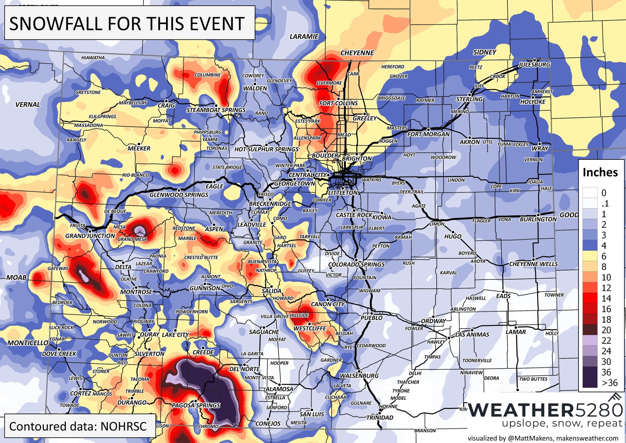
As you can see, bigger totals in the foothills and along the front range as you went north. Overall, a pretty decent forecast, even if the timing was a bit off. The snow from this morning helping bolster a multi-day cold and snow event.
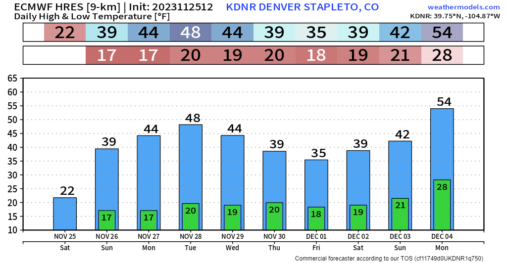
A quick peek at the 10-day temps show a bit of warmup going into Tuesday before another cold front arrives on Thursday and Friday. At this time, not much moisture is expected during that time, but we'll keep an eye on it. Use Weather5280 to stay ahead of any incoming weather by subscribing to our email list today!