Friday morning update: Snowfall forecast for Colorado, Denver area over the holiday weekend

We continue to track a change in the weather due to arrive this weekend and bring with it some rain, snow, wind, and cooler temperatures as we move through the long holiday weekend.
In yesterday's update we focused a lot on all the moving parts and why this forecast remains a complex one. Today we'll narrow in on possible scenarios a bit more, timing, and impacts.
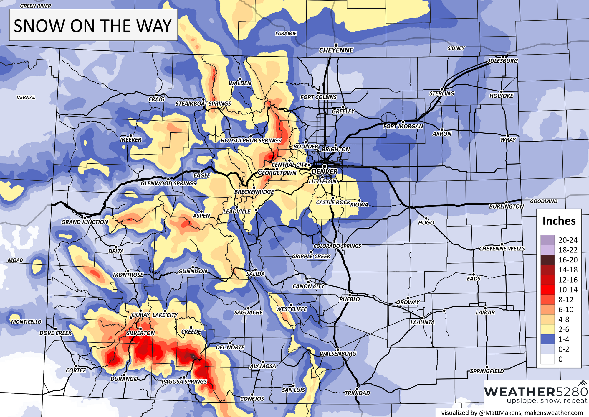
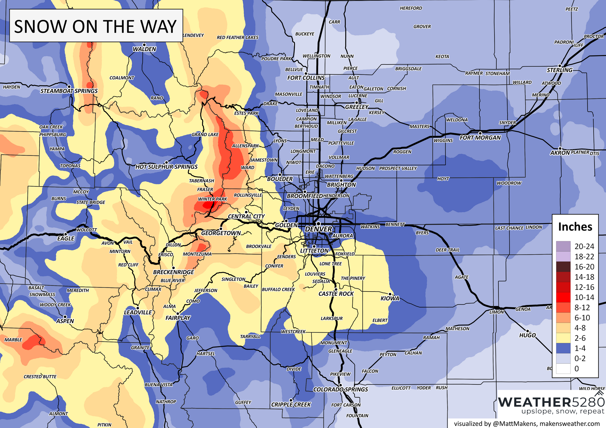
First, plenty of uncertainty remains, particularly with how much snow we'll manage. There are still two camps – one that would broad-brush just a Trace to 2" across most of the lower elevations and another that would offer more areas a 2 - 5" snowfall. Details in how the two systems at play come together, how much moisture we lose to rain/mixed precipitation, and how much of a northerly/drying wind we have to contend with will be the determining factors in how everything ultimately shakes out.
Timing and impacts
We have what we think is a better idea of the timing of things this weekend today. That is, the chance of rain and snow picks up in earnest Saturday evening across the greater Denver metro area, continues through Sunday morning, and gradually diminishes throughout the day Sunday. For the urban corridor, what snow we do see Sunday is likely to be scattered and light in nature, with gusty north winds and chilly temperatures to boot.
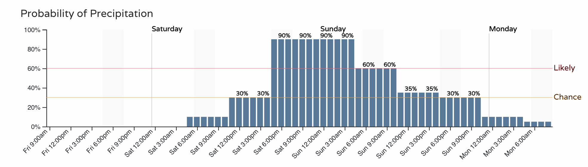
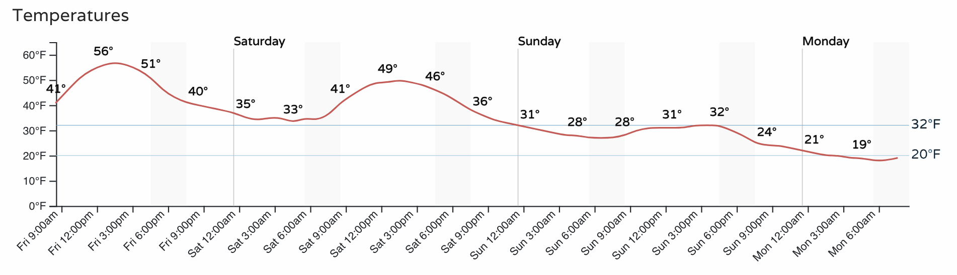
Speaking of temperatures, we'll go from highs in the mid 50s today to just near freezing on Sunday with those lingering snow showers across the plains:
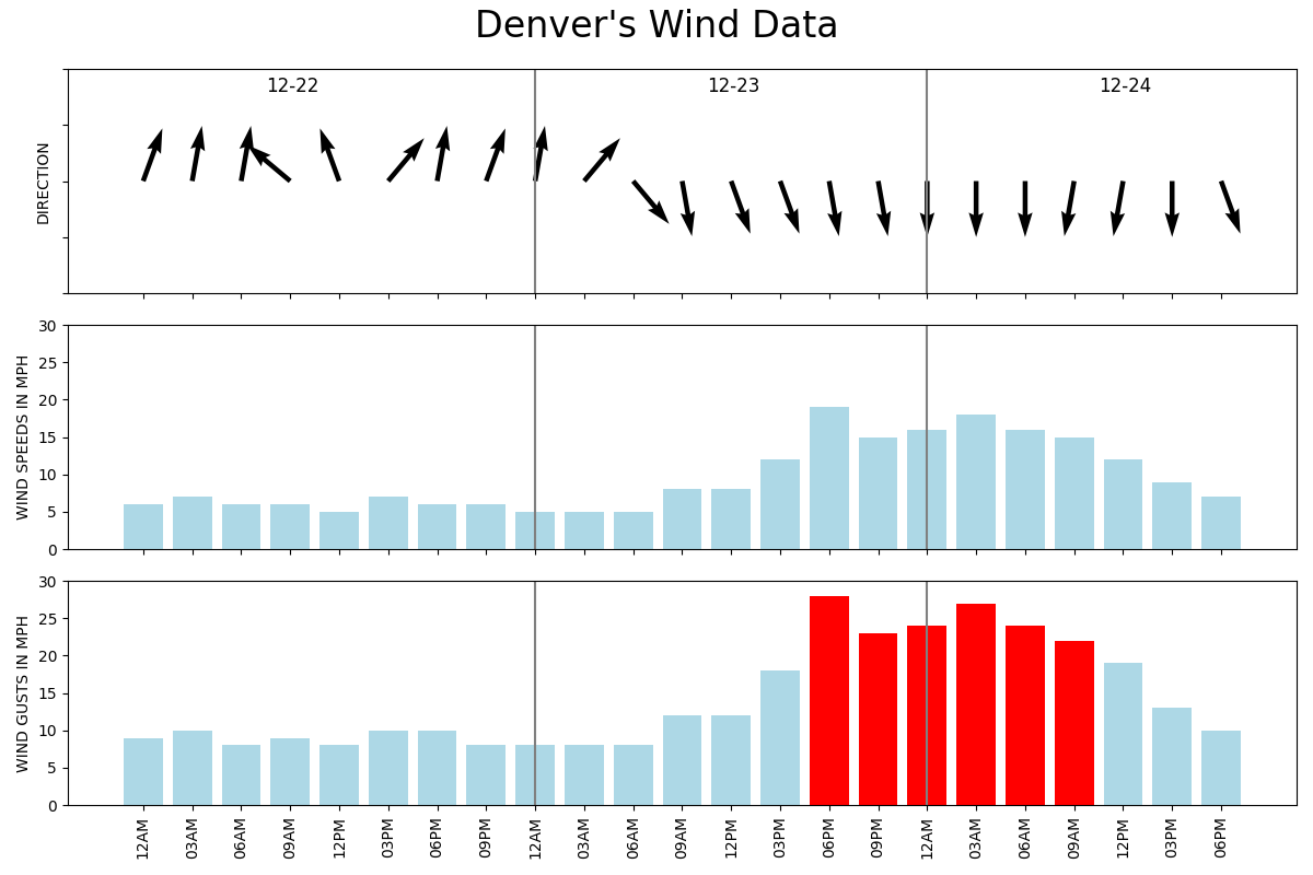
A northerly wind kicks in Saturday night and carries through the day Sunday. It'll be quite gusty at times with gusts of 30 to 40 mph. Where we are seeing snow this could lead to additional travel hazards.
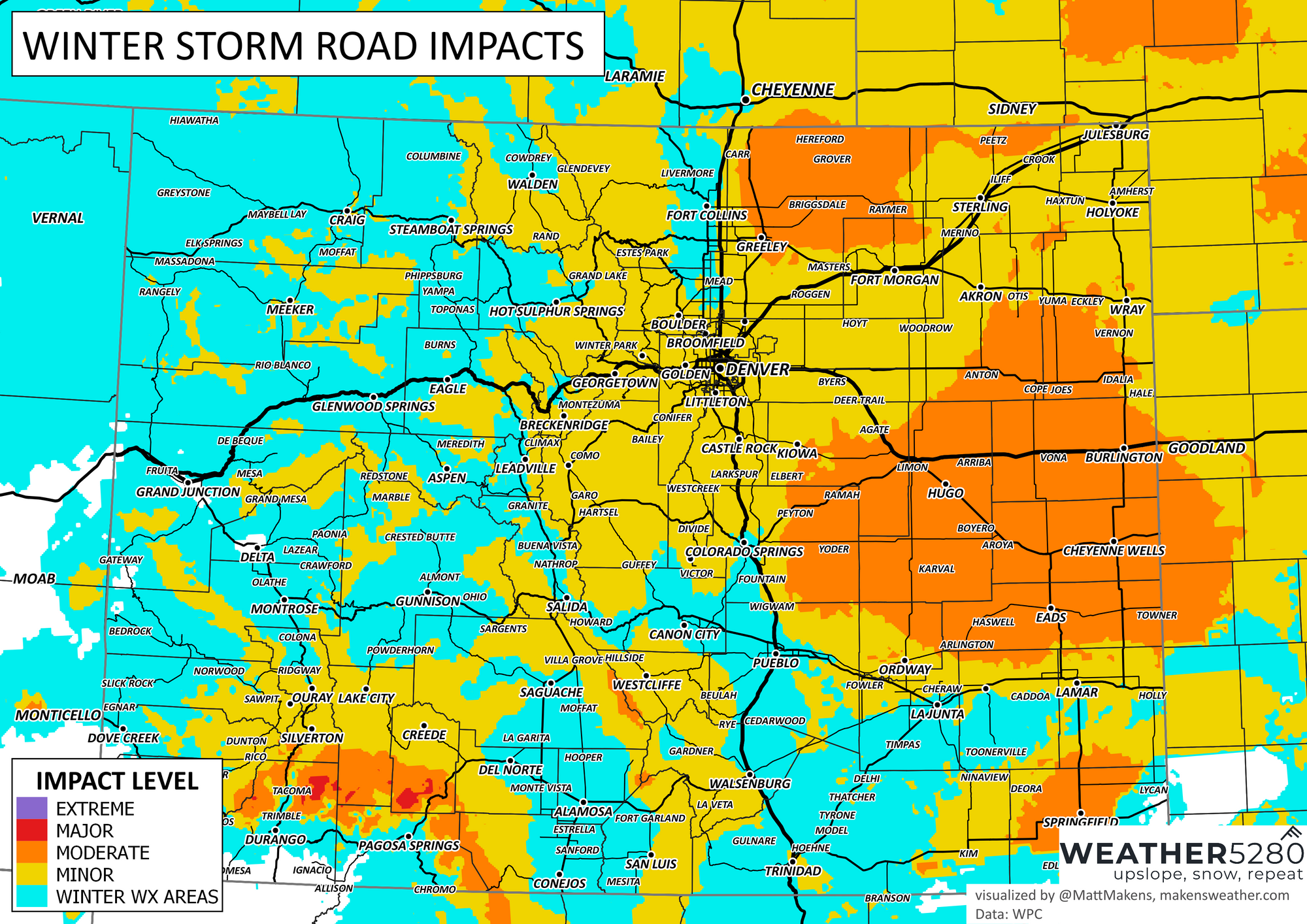
We'll see travel impacts across much of the state as the wet weather moves in, in particular across Eastern Colorado with that snow and blowing snow that's expected. The worst travel across the plains should come between Saturday evening and Sunday afternoon, with improving conditions as we head into Christmas Eve night. So if you're traveling by car Saturday night you could run into some issues, but if you're traveling by sleigh Sunday night you should be okay!

Snowfall forecast
Sorry to say, but confidence remains quite low!
Confidence is highest along the Palmer Divide as temperatures won't be such an issue at the onset (perhaps no rain to contend with there) and a northerly wind isn't such a snow-killer there as it is up north for places like Fort Collins and Loveland, or even Colorado Springs. Here we expect 2 - 6" by the time things wrap up Sunday evening.
For Denver, 1 - 4" seems like the safe bet. The further north and east you are in the metro area the lower those totals are likely to be, with higher totals favoring the southern and western suburbs.
For Colorado Springs the northerly wind showing up in much of the data isn't a great indicator that'll you'll see a lot of snow as this produces downsloping across the city. Right now we have COS in the 0 - 2" range for snow.
Colorado forecast:
Front Range forecast:
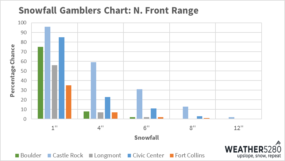
The gamblers along the Front Range show highest confidence in the 1" range, but things drop off for most cities as we start looking at 4" of snow or more. The Palmer again holds out hope for those higher end snowfall totals. If you're holding out hope for a bit pre-Christmas snow, these odds leave a lot to be desired.
We'll keep tracking things today and offer updates as needed. I'll say most guidance is supportive of the numbers above as of this morning, but there's still some bust (fewer boom) scenarios on the table. The European model, for example, is slower with the secondary system and has a lot more downsloping wind for us throughout the event, and should be be right we could end up hard-pressed to manage even the low-end of our forecast ranges above.
Time will tell.
We wish you all safe travels this weekend, and please stay on top of the changing weather by subscribing to our email list for updates. It's free!