
Monday AM update: Heavy rain and snow a possibility for Colorado next weekend, so too is a near-miss

We've been talking about the early days of February for a couple of weeks now on Weather5280, and for Insiders we had an update on what we're watching for the month yesterday as well. From a forecasting perspective, things certainly look "interesting", while the uncertainty remains quite high as to how things will ultimately pan out.
We'll get in the weeds a bit here, and then breakdown what to track as we get closer to next weekend. In short, the potential for widespread rain and snow across Eastern Colorado from Friday PM through Sunday PM is on the table, but fluctuation in track and temperatures means anything from a "boom" to "bust" is on the table.
Modeling
Operation models have been pretty wild in their varying solutions over recent days, but decent consistency in ensemble guidance suggests odds we get something is favored over a complete miss.
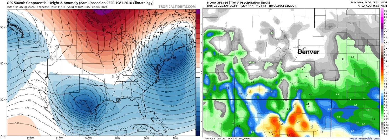
The GFS in particular has been quite spectacular, even for it. Let's look at the last 3 runs from the operational GFS from yesterday afternoon, evening, and overnight. A couple of things to note – the first being, a swing from 0.0" precipitation for Denver to over 2.0" of precipitation in just three consecutive runs (wow!), and the second being which solution is closest to its ensemble, which has been relatively stable.
Yesterday afternoon – Low in south Texas, northeast Colorado mostly dry through the duration of the "event":
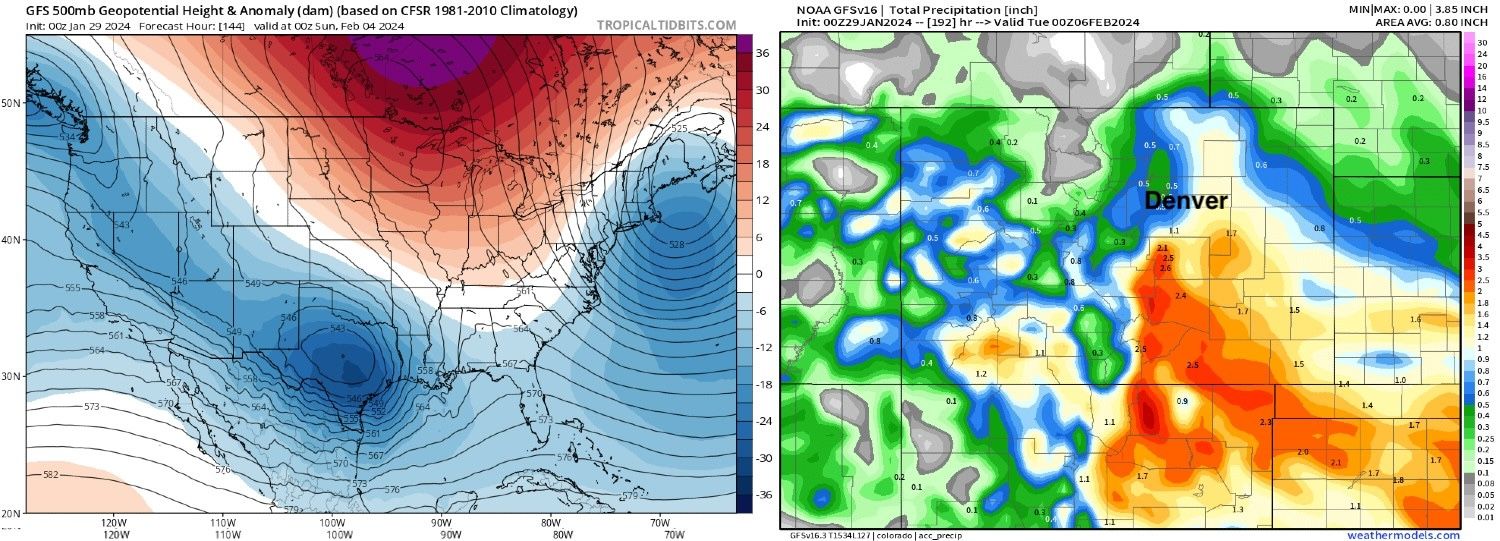
Yesterday evening – A tick north on the storm track, and quite a bit more moisture for Eastern Colorado, about 0.5" for the Denver area, but the storm track still a bit too far southeast for the northern Front Range:
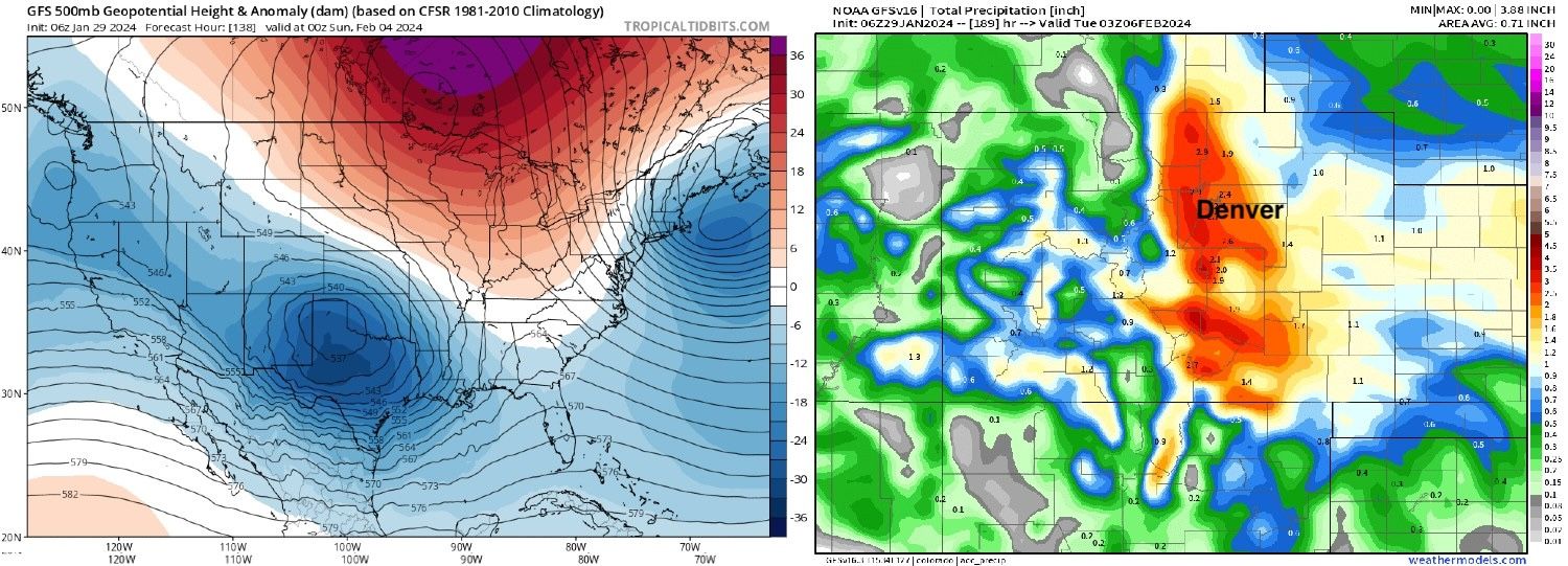
Overnight run – Low tracking through the sweet spot, very slow easterly movement over the weekend, and copious amounts of moisture along the urban corridor north-to-south:
One might be tempted to call this a trend if it weren't almost as predictably going to do something wildly different today with its output. Still, if you're hoping for snow along the urban corridor hard not to find the positives in the recent runs.
Now, if we look at the GFS ensemble mean from the last 3 runs we also see a tick north, but note that it was never nearly as far south as its operational run.
And if we compare that to the last 3 runs from the European ensemble mean, we see that 1) it's been far less reactive, and 2) the GEFS appears to be wanting to move toward the Euro and not away which is always a good sign for forecast confidence.
In fact, ensemble consistency has been quite good over recent days. If we look at the European mean precipitation forecast for Denver for next weekend we see it produces about 0.8" of liquid for the city. I went back and looked at the last 8 runs of this and which were the same, or within a tenth of an inch.
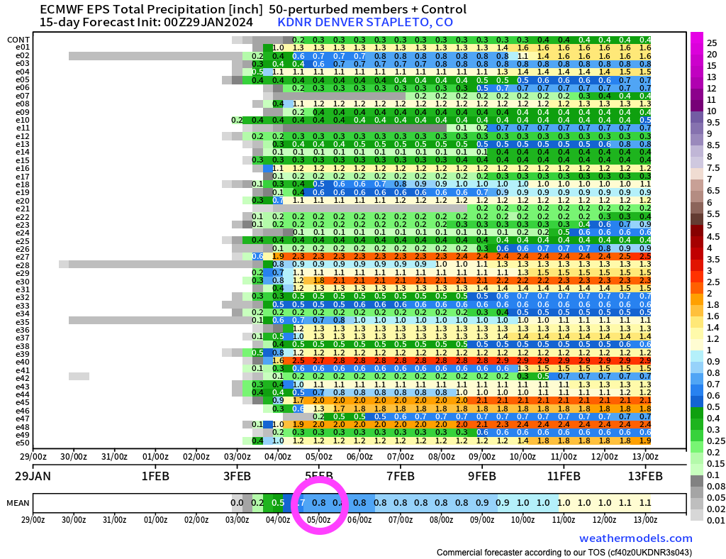
If you look at the lines across the y-axis in the chart above, each "e" number (i.e. e24) represents an individual ensemble member forecast for precipitation over the next 10 days. As you can see, even with the healthy mean there's still a wide range in possibility – that is a few members with just 0.2" of liquid next weekend, and others with 2.0"+!
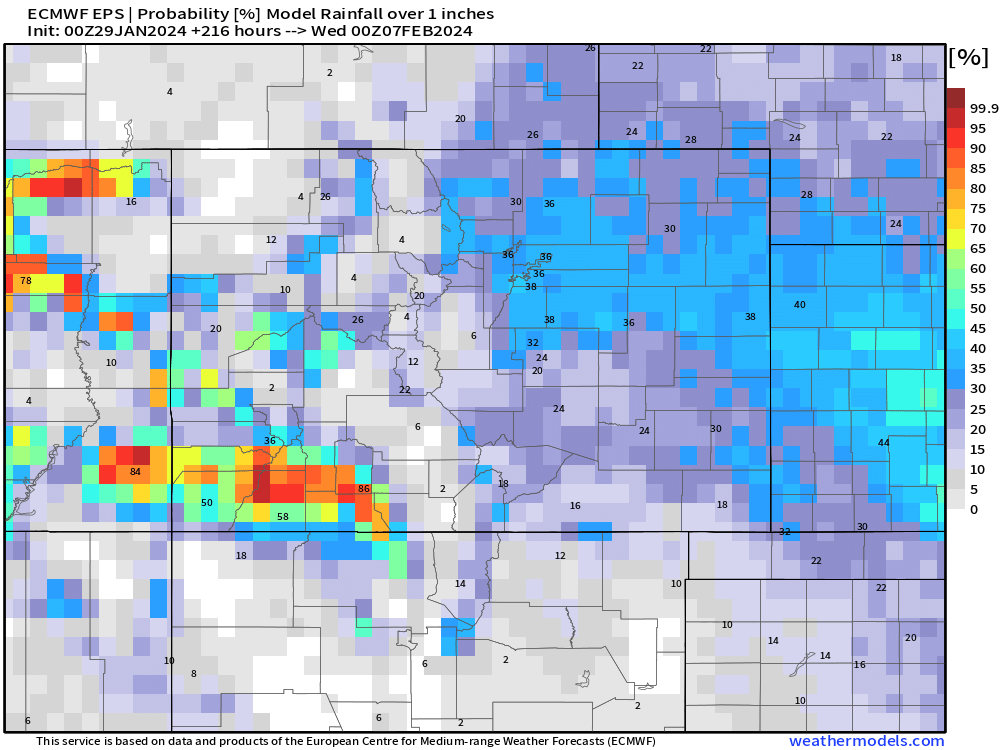
Probabilities for precipitation totals of more than 1.0" through next weekend remain on the low side given the uncertainty, but given we are still about 5 days out not awful either. Ensembles aren't going to do a great job picking up the more extreme solutions, especially at range.
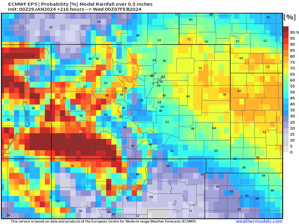
For a half inch of precipitation or more a better than 50% chance for most of northeast Colorado:
Rain vs snow
Now, assuming we get the track to align in a favorable location for moisture along the Front Range, are we talking rain or are we talking snow?
There have been some concerning model runs with regard to where the rain/snow line sets up initially, with some solutions wasting more than half of the available QPF on rain vs snow at elevations less than 7,000 feet or so. I'm a bit skeptical of this given the time of year, and also how often models underdo cooling even in an environment where it can be exceptionally hard to buy cold air, even in early February it seems 🙄.
I'm thinking we'll be mostly snow, even at lower elevations, but some rain at the onset is possible and too much rain would clearly eat into totals. We'll also be talking relatively low snowfall ratios, so even if all snow it will be a wet, compact snow vs the very fluffy snow we saw with the cold earlier this month.
So, while often we'll see 20:1 or better ratios this time of year (that's 20" of snow to every 1" of liquid), it could be that the bulk of this storm is closer to the 10:1 ratio – plus or minus.
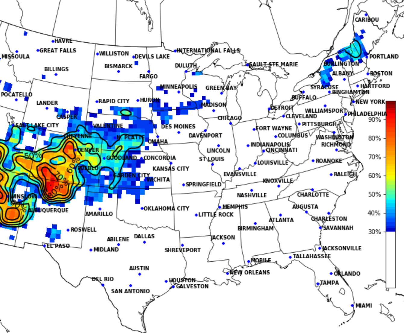
As to how much snow we're likely to see? It's simple too early to say. Back of the napkin math would suggest ~8" for Denver if the (rather consistent) European ensemble mean is right, BUT as you saw above, even many of its ensembles are showing a near-miss vs hit for the Denver area with this storm. For the snow-lovers in the group, here's the latest analog guidance for 4.0" of snow or more, not horrible odds, especially at elevation west of I-25.
TL;DR
We are tracking a power winter storm that will swing through our region from Friday PM through the weekend. With low confidence in eventual track, impacts could range from a bit of wet rain and minor slushy snow accumulation to a more significant snowfall event along the Front Range urban corridor. While just about every scenario is on the table, better agreement in modeling today, and relative consistency in ensemble guidance suggests many of us will see some snowfall next weekend, but how much remains in question.
No need to make any major life adjustments at this time, but there's most certainly a need to subscribe to Weather5280 and stay ahead of any storm (or lack there of) that may head our way later in the week!
And remember, friends don't let friends share off-run GFS snowfall maps for storms 5 days away! So if anyone shares a map with 20" snowfall totals with you this morning, feel free to share the one above from the same model 12 hours ago which had... 0 inches! 😆