Guidance again hints at some big-time snow, but will it *stick*? Latest forecast and discussion for greater Denver area snow this weekend

This has been one of those weeks. Here we are just hours out from the arrival of our weekend storm, and I think most forecasters if they're being honest would say we don't have a great idea of how things are going to ultimately pan out. Just about everything is on the table still, from being dry-slotted, to more rain than snow, to well... a healthy amount of heavy, wet snow across a good portion of the urban corridor.
It's really been one of those weeks where things just haven't quite added up. Like how can we see that much QPF on model A but so little snow, or why is this model nosing a dry slot overhead, but this one is not, or why are we hinging our snowfall expectations on the storm delivering when it's nearly cleared southeast Texas. It's a mess, all of it, but really predictably so as you can see in this highly sophisticated conversation Brian and I had way back on Monday!

And well, guess what. Thursday arrived, and so did some pretty monumental model changes. The GFS which had been all but drier for about two or three days is back to spreading copious amounts of moisture up along the urban corridor, and the steady European has trended (you guessed it) the other way!
Let's dive in.
Let's start with what we know
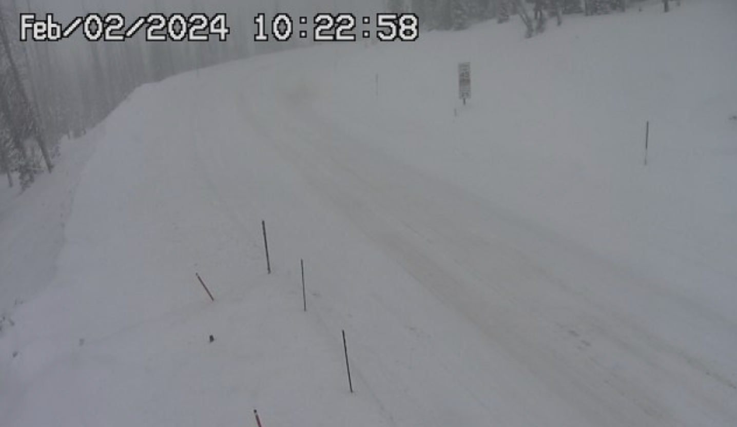
Changes are coming. In fact, for some parts of the state they've already more than arrived. Here's the scene from Wolf Creek Pass this morning, with quite a few road closures already in place across the high country today.
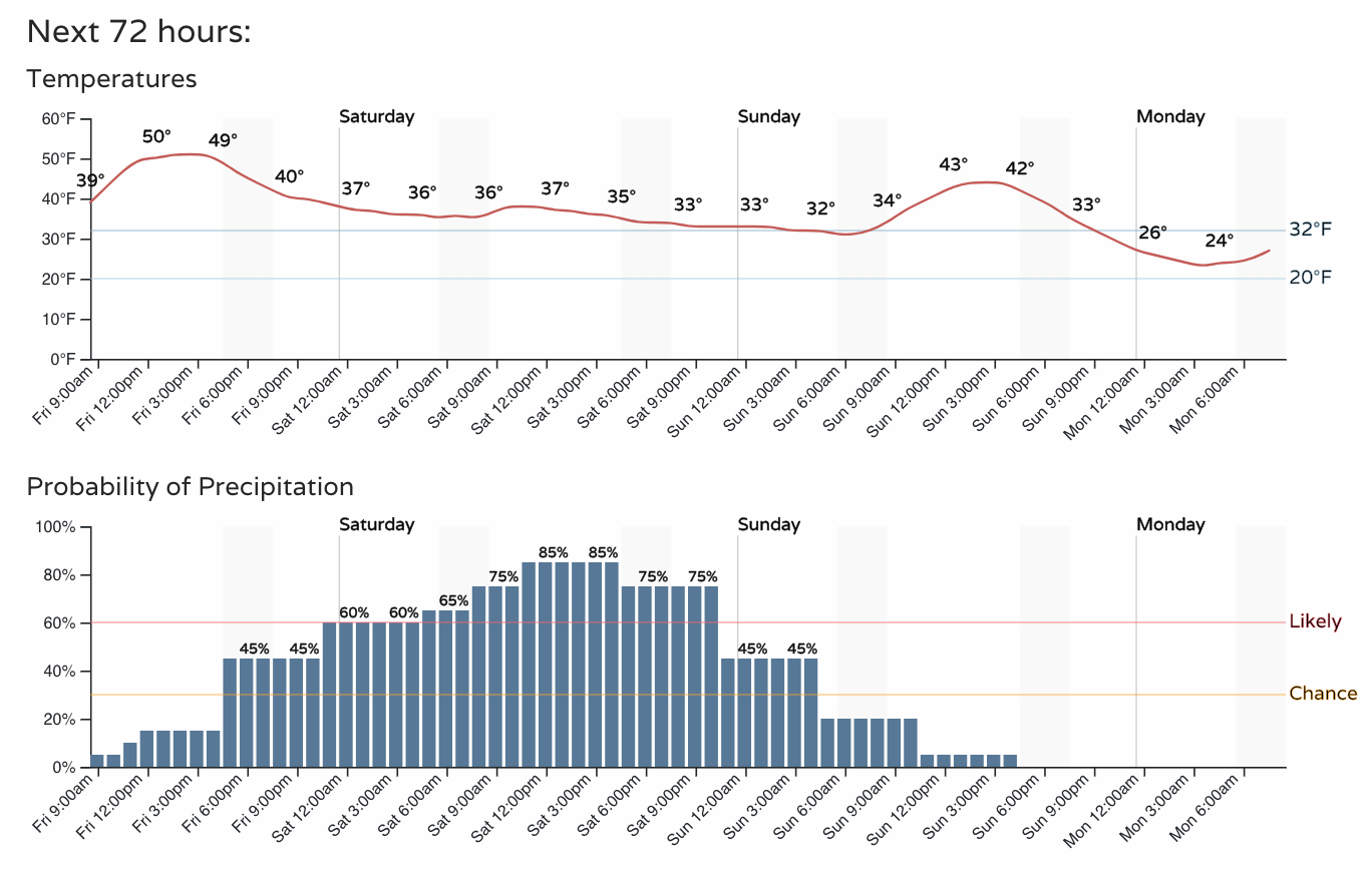
For the urban corridor, one way or another, the weekend won't be the 60-degree weather we've seen over the last couple of days. Rain, snow, or shine most of us should manage some cooler and wetter weather this weekend, with most of us already feeling those changes today – though overall temperatures remain mild.
We also know that the incoming storm will take a pretty favorable track all things being equal for someone to end up with some pretty good moisture (and in theory snow) before things wrap up Saturday night/Sunday.
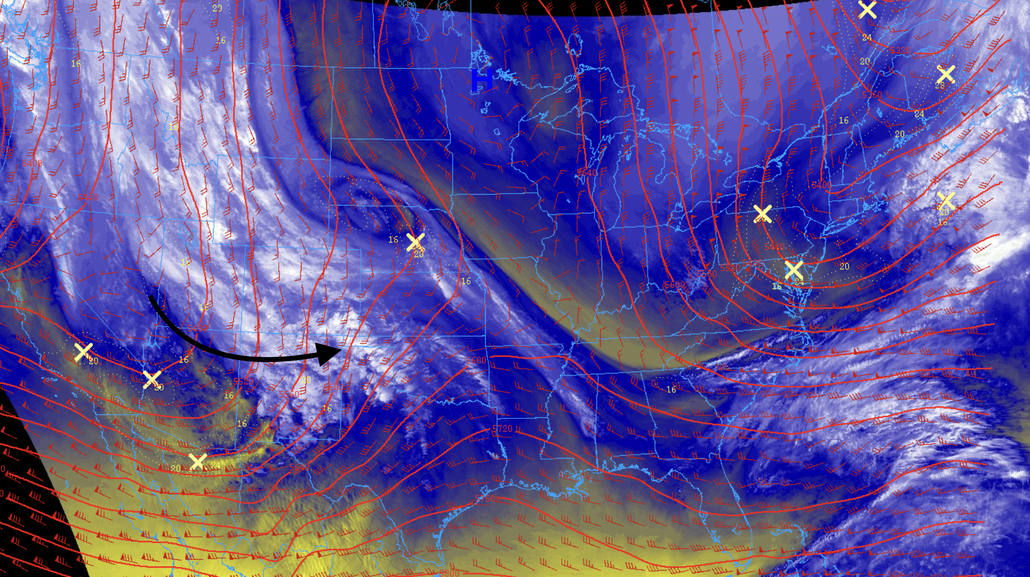
The trough is currently nosing its way into the Great Basin, and will track through northern New Mexico overnight tonight and into the Panhandles Saturday morning.
As the trough moves to our east/southeast it'll pull moisture around it and up into eastern Colorado. Where upslope is greatest and air temperatures are coldest, we are likely to see several inches of heavy wet snow between tonight and Sunday morning.
Latest model guidance
Model guidance has been nothing short of a mess. The GFS has finally come around to showing a moderate to heavy snowfall event for much of the urban corridor (including the Denver area!), but of course the question is – is it right?
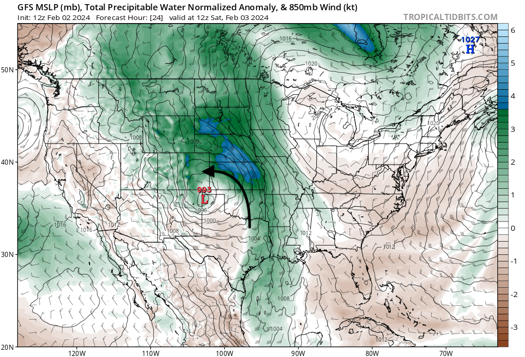
Let's look at the GFS first. Here is its 500mb forecast Saturday morning:
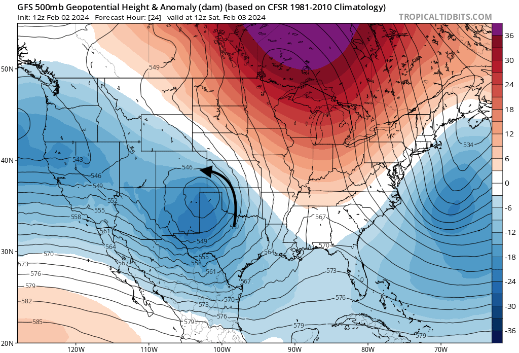
Honestly, that's just about where you'd draw it up if you were asked to draw a favorable storm track for snow along the urban corridor. And, look how much anomalous moisture it pulls up from the gulf with it, slamming it right up against the hills...
So, how is that different than prior runs from the same model this week that were all but dry for many of us? Here's a run from a few days ago... note the 500mb low is much broader, slightly further west, and not great circulation to really draw that moisture into our area. You can see at the surface (bottom right) the low is also further north and pulls in a lot of dry air into northeast Colorado, keeping the best push of moisture to our east and north:
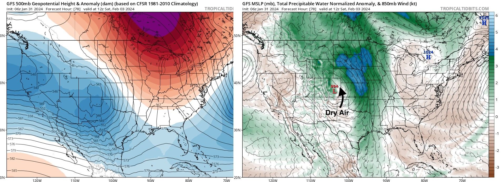
This is of course a simplified example, but you can see – minor differences in strength and track but massive differences in outcome. The solution from a few days ago had about 0.2" of RAIN in Denver, while the current solution produces 10 - 14" of snow for the city. Goodness me.
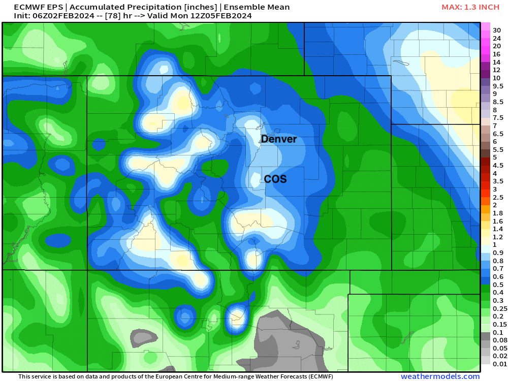
While the ECM model has largely moved away from its heavier snowfall solutions, its ensemble remains pretty bullish. Here we see 0.5" to 0.9" of QPF in the means really north to south along the urban corridor. If everyone where to see 10:1 snow from this event that would mean 5 - 10" of snow for all cities. Of course, that doesn't appear to be the case – but if Denver cools enough that would certainly be on the table, while cities north and east (Fort Collins / Greeley) may see more rain and less total precipitation. You'll note that the mean for areas between Denver and COS are roughly 0.8", with most if not all of that being snow, pointing to a 6 - 10" event there, with probably some good upside potential to see 10"+ for some locales.
So where does this leave us?
It leaves us with a tough call. Do we favor the models that continue to show a relatively low-impact event (particularly at elevations of less than 5,500 feet) OR do we jump on a the heavy snow train with high bust potential?
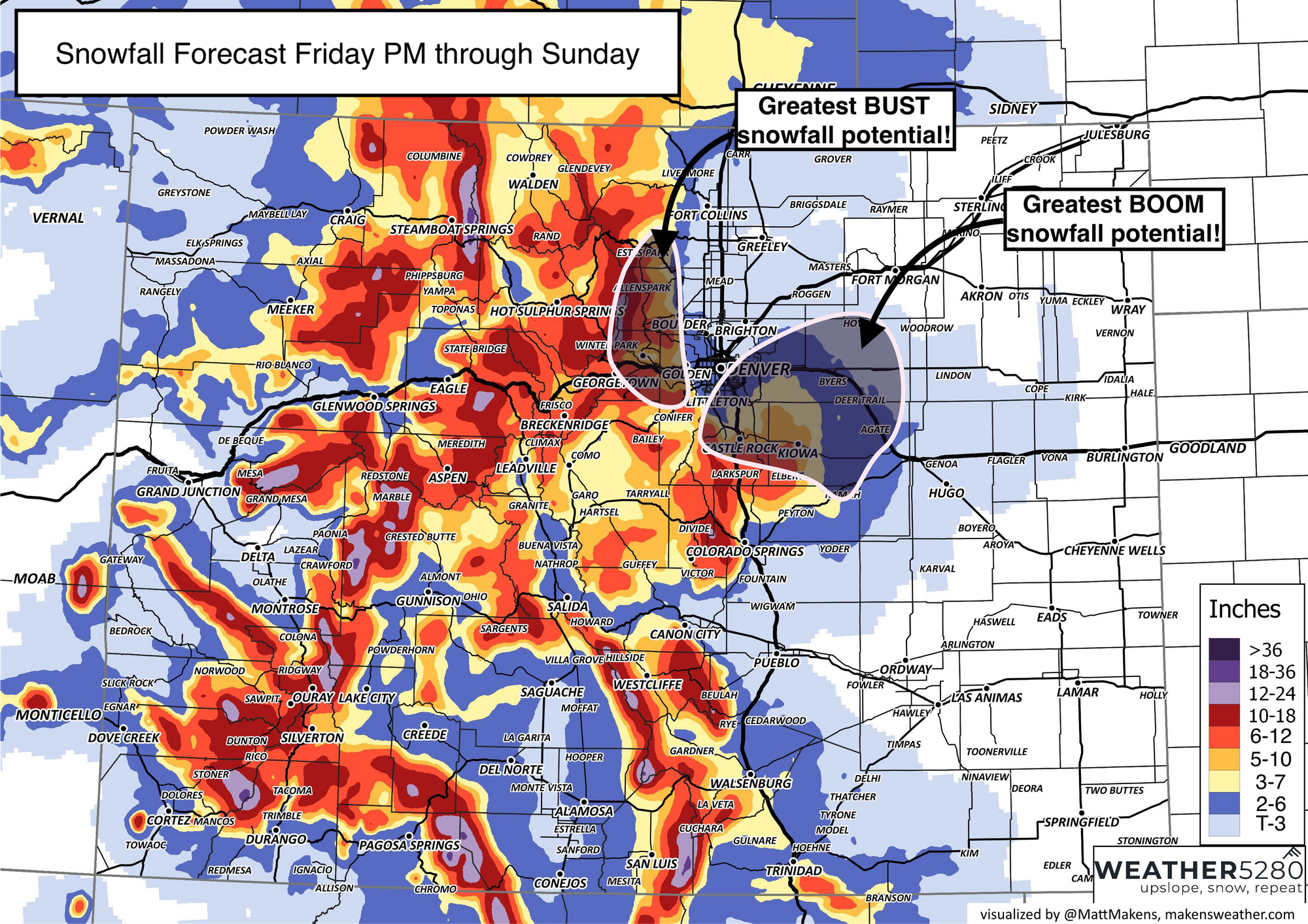
I'm inclined to jump on the heavy snow train, but I think our forecast will remain a bit couched as confidence just isn't great, especially for Denver and points north. If you live across the Palmer Divide, and what increasingly like southeast Denver (Parker area) your odds of a more significant snowfall remain much higher. For the Palmer Divide including the cities of Castle Rock, and Larkspur, at Winter Storm Watch goes into effect early Saturday morning and remains in effect through Saturday night.
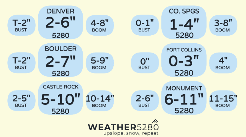
Given the wobble back to better odds for greater snowfall, you'll see we've upped numbers a bit since yesterday for some cities (and yes, these are wide ranges, we know):
Fort Collins: 0 - 3"
Loveland: Trace - 3"
Boulder: 2 - 7"
Conifer/Evergreen: 5 - 10"
Denver (downtown): 2 - 6"
Denver (south/east): 3 - 7"
Castle Rock: 5 - 10"
Monument: 6 - 11"
Colorado Springs (north): 3 - 8"
Colorado Springs (central/south): 1 - 4"
Below is our latest forecast. We've highlighted the areas on Denver's south and east side that may be favored for that band of heavier snow to setup on Saturday, and if it does some localized impressive totals will be possible. That does NOT rule out that band making it further west over more of the city, but odds appear lower for that scenario at this time.
Travel impacts will be plentiful across the state through much of the weekend. For the Western slope we are already seeing that rain and snow today, and coverage will only increase across the high country tonight. For the urban corridor, the worst of the snow looks to come between 2am Saturday and 10pm Saturday night, but leave some wiggle room for that timeline as well.
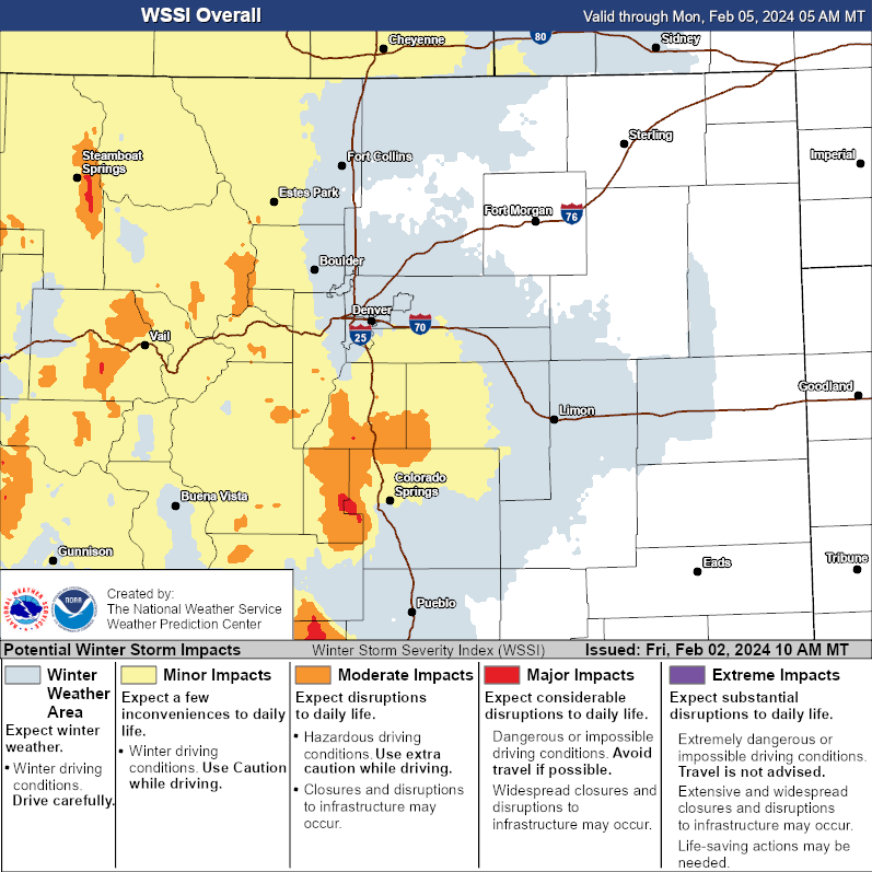
Current WSSI isn't crazy, but if confidence grows on higher snowfall potential, we'd likely see this map reflect those changes in future iterations as well.
What to watch for
Updates from us, of course!
We'll keep watching things today and pass along another update if needed. Will we see everything collapse in the end? Or has all this back and forth all week been leading to one of the bigger snowstorms of the season for some of us? Time will tell!
Subscribe to our email list, it's free!
More to come, and as always please keep us posted in the comments below.