
Colorado snow storm delivers heavy wet snow, plentiful moisture; A quick look ahead

A quick post this evening to share precipitation and snowfall totals from our storm yesterday. It was a wet one, really by any measure, but particularly for the first days of February.
Denver International Airport picked up 5.5" of snow, we had forecast 2 - 6" for the city. The storm also delivered 0.76" of precipitation, which is nearly double the monthly average for the month of 0.41". Wow! AND DIA was some surprise (surprise) not all that representative of what we saw over the core of the city, picking up at least 1.0" of liquid, and well more than that for the western suburbs:
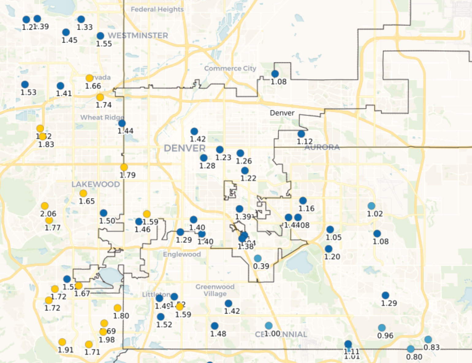
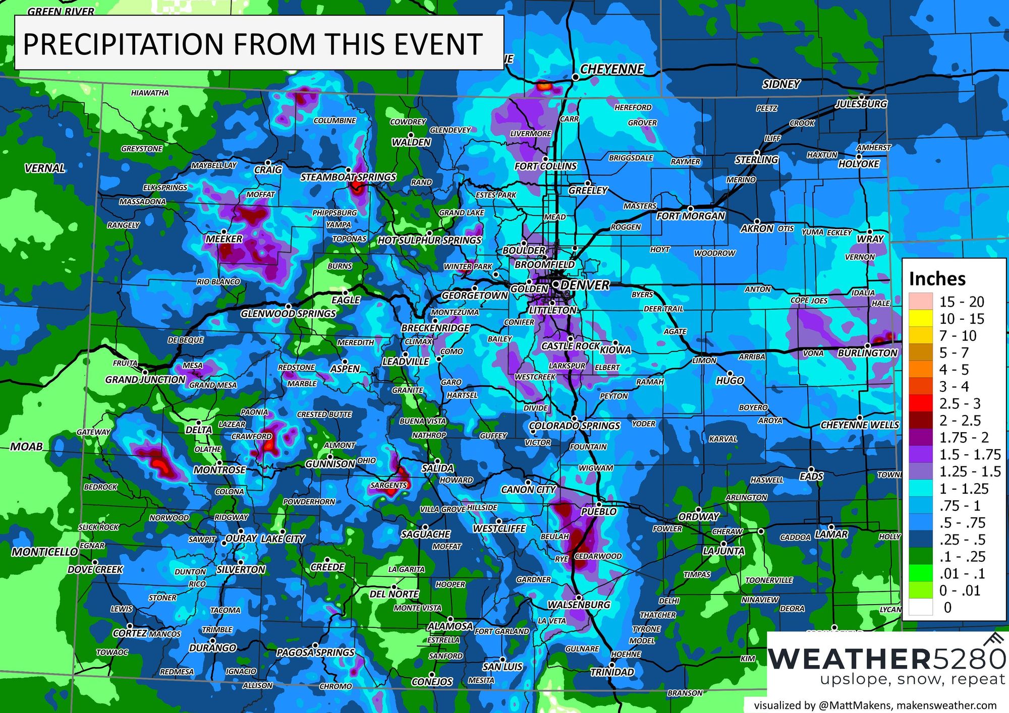
Denver wasn't the only city that saw wildly anomalous precipitation from this event. Under the barrier jet that setup we see the Gulf moisture deliver remarkable water up and down the Front Range from this system. Check out Boulder with 1.58" of precipitation from this storm!
Boulder recorded its wettest winter day on record yesterday.
— Chris Bianchi (@BianchiWeather) February 4, 2024
1.58" of precipitation (6.9" of snow) beat 1.47" (12/5/1913) for that mark.
Official records in Boulder date to 1893. Winter = Dec. 1 - Feb. 29.#9wx #COwx
And Fort Collins picking up more than 3x the average for the month of February from the storm:
Final storm total from CSU Campus Wx Station in FOCO was 1.59 inches water equivalent. That is more than 3 times the average for the whole month of February. #cowx @BianchiWeather @AshtonCBS4 @weather5280 @MattMakens @CReppWx @KerrinJeromin @CReppWx pic.twitter.com/xERQFJ5azD
— Howard Gebhart (@GebhartHoward) February 4, 2024
The map of precipitation totals shows that a lot of the state saw appreciable moisture with this storm, and again highlights where that Gulf moisture got pushed against the mountains. Great stuff.
Likely saved by the fact it is early February and not even a few weeks later in the spring, the rain did change to snow at lower elevations in relatively speedy fashion, and even with daytime snow we managed to log some pretty healthy snowfall totals up and down the urban corridor and into the foothills.
Here are the statewide totals, with the heaviest snow across Denver's western suburbs and the Palmer Divide, but plenty of 4 - 6" totals for Denver proper as well.
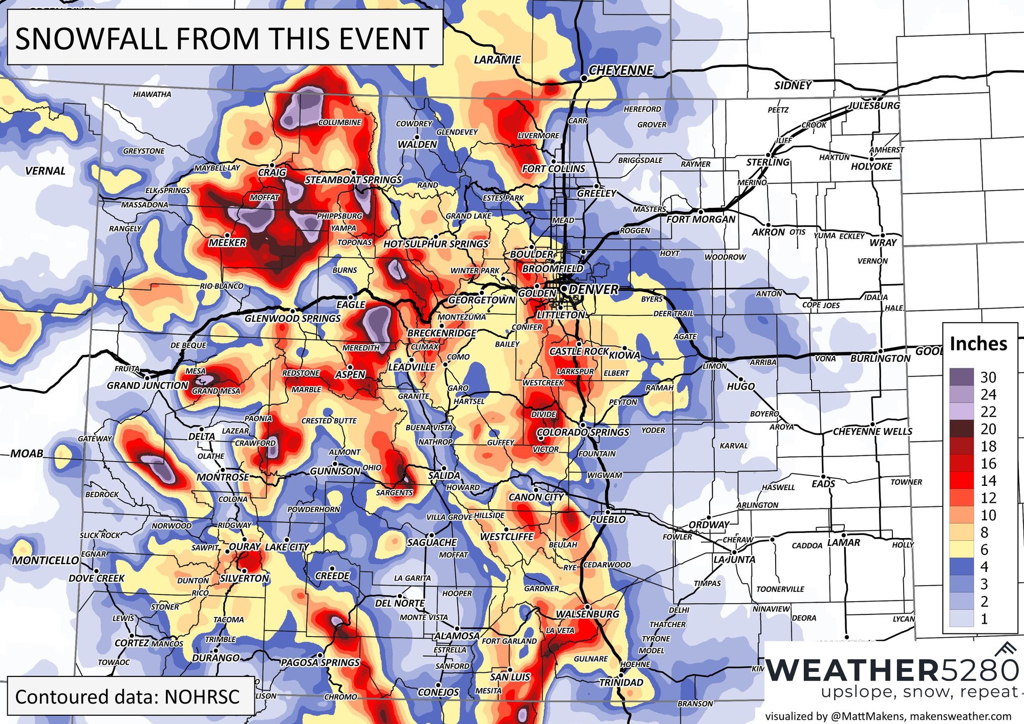
The greatest totals came from the immediate foothills west of Denver, with some 16 to 20" totals reported for places like Genesee, Indian Hills, and unincorporated Golden. Snow here took the longest to quit Saturday evening even as the snow machine shut down elsewhere along the Front Range.
And of course, it wasn't just the Front Range. Look at this bluebird day skiers enjoyed at Wolf Creek this morning with 18" of fresh pow to enjoy!
Sunday Funday at Wolf Creek Ski Area was a great one!! 18 Inches from the latest storm made for happy skiers and boarders!! Tuesday, February 6th, features a Tuesday Turns Ski & Snowboard Clinic. Details can be found at https://t.co/d3xBRkSokY. 📸: @kevinbruce94 #wolfcreekski pic.twitter.com/vZq5MaEGhM
— Wolf Creek Ski Area (@WolfCreekSki2) February 4, 2024
The week ahead
The main focus of the weather today is in California where FEET of snow is falling at higher elevations and record rainfall is expected across lower elevations along the coast.
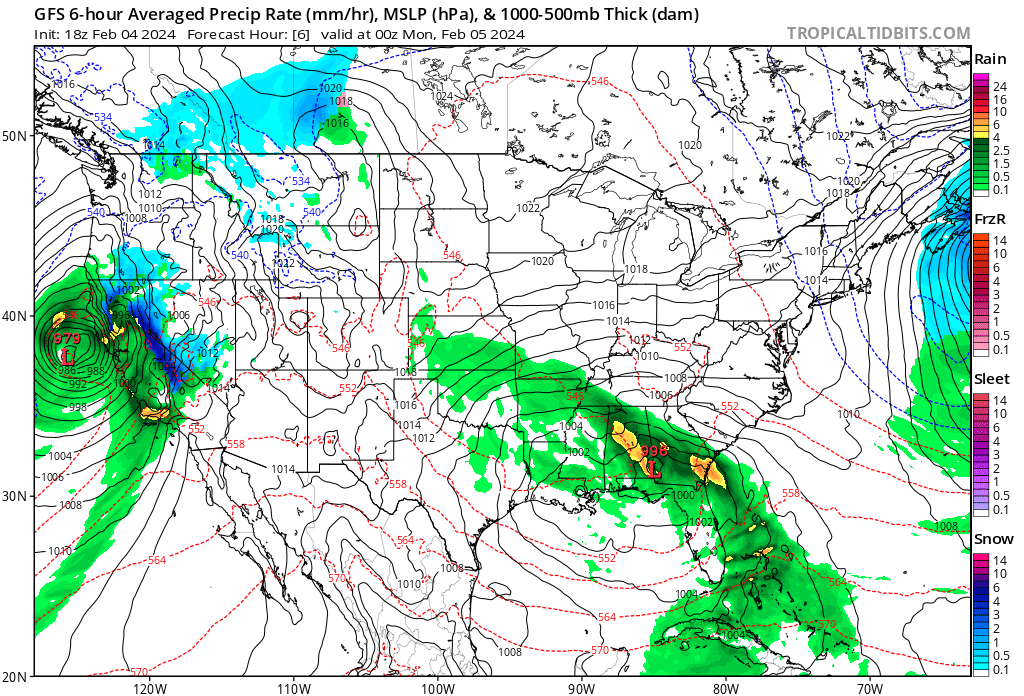
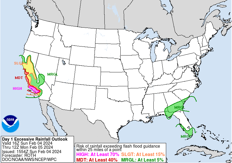
The powerful storm will move inland over the next 24 hours or so, and eventually pull more rain and snow into Colorado by the middle part of the week. The greatest impacts are expected to be across western Colorado with this next system, but we can't rule out a bit of wet weather across the eastern plains by midweek, stay tuned.
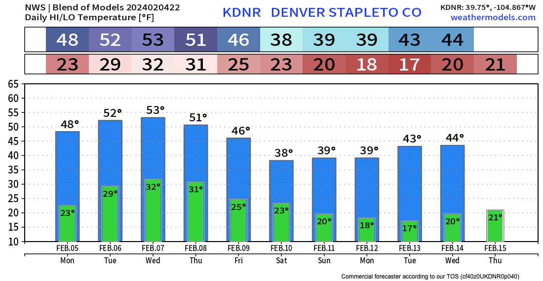
Temperatures will be pretty mild for the next several days, with highs in the upper 40s to near 50F tomorrow in Denver, and then the low 50s through Thursday.
Something perhaps a bit more organized moves in late in the week/next weekend, but data is messy with what that may or may not look like with little agreement in in the modeling at this time.
Happy Sunday everyone!