High-end potential? Colorado Snowstorm eyed for Thursday

We've kind of seen it all so far this winter and early meteorological spring in Colorado. A few busts, a few booms and a few in-betweens. This week, however, arriving right on time, could be a mid-March special...
Any of you model geeks, us included, have seen some of the booming snowfall potential with the storm set to come through around Thursday, potentially lasting well into Friday, and in some instances... until Saturday! Now, not even 96 hours out from this storm we cannot confidently call for a 2-3 day monster snow event, BUT, we do have increasing confidence in a storm that should bring impactful winter weather to parts of the region.
Let's start with the good stuff first:
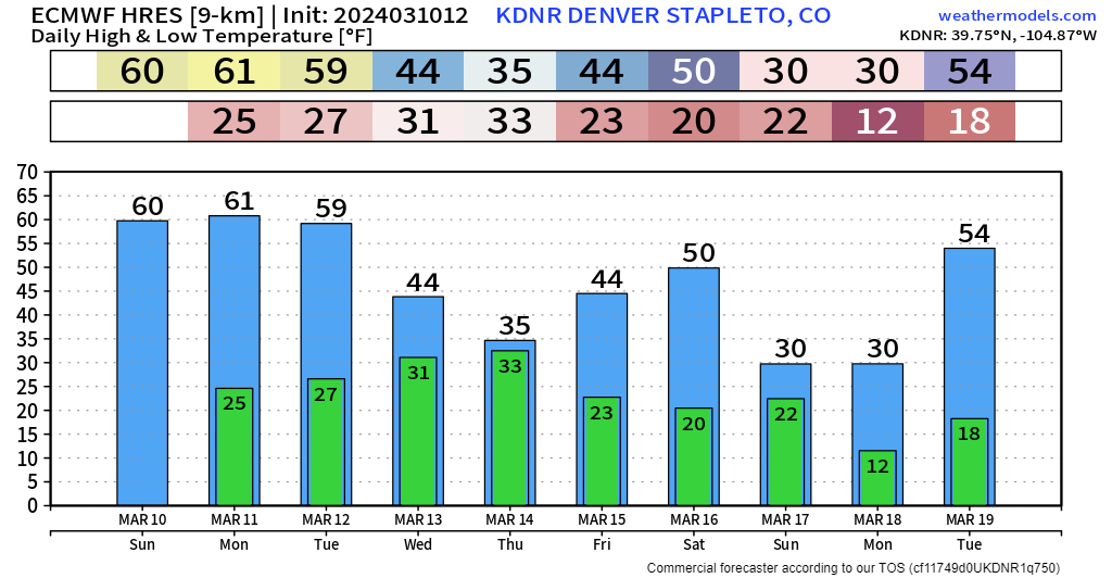
The next few days are great! Hope you're going to get out and enjoy that extra hour of evening sunlight today, temps are perfect and we'll stay mild into the start of the work week. Things will go downhill quickly Wednesday afternoon as a cold front slides by.
Before you read any further, just know that we still have uncertainty with this storm... The timeline below is just a rough sketch of potential conditions based on the data we have now, and the forecast WILL see changes as we approach storm time.
Now that that's out of the way, a quick/dirty timeline for this storm would be something like:
03/13 Wednesday morning:
Snow quickly picks up in the northern mountains, travel deteriorates quickly.
03/13 Wednesday afternoon:
Rain showers pick up shortly after noon for the northern front range and metro Denver.
03/13 Wednesday night:
Rain transitions to snow after sunset, with snow spreading south over the Palmer Divide and into southern Colorado. Snow could be heavy at times.
03/14 Thursday morning:
Snow continues, heavy at times, potential for high-impact to travel, airline delays etc...
03/14 Thursday afternoon:
Snow will continue, slowly lightening up to a moderate clip by the evening rush, impactful conditions still possible.
03/14 Thursday night:
Accumulating snow is generally winding down. Cold air would lead to refreeze issues.
03/15 Friday:
Digging out, staying chilly, light snow showers throughout the day.
Forecast Uncertainties
1) Storm Track
At this point, we've felt a little uneasy with how far south some of the data is tracking the upper low, and this will be the biggest concern with any high-end potential models are trying to produce with this system.
It does see a few moments in some sweet spots, but it also does A LOT of digging, in some cases as far south as Yuma, Arizona – and for the uninitiated, that's not good for us snow lovers along the northern Front Range. Still, some data has trending a bit further back northeast in recent runs, and the track is enough in the ballpark that this one will demand our attention over the next few days. If the system digs too far southwest too quickly, upslope will shutoff quicker and hamper snowfall production along the Front Range.
2) Storm Speed
A slower storm means more moisture.
If we can get this thing to set up a bit further northeast, we may see accumulating snow prospects linger into Friday too.
Regardless of what model you look at, this storm doesn't look like it will be in and out like most we have seen so far this year.
Below are animations of the upper-level storm track from the GFS and EURO ensemble charts, GEFS and EPS for short, respectively.
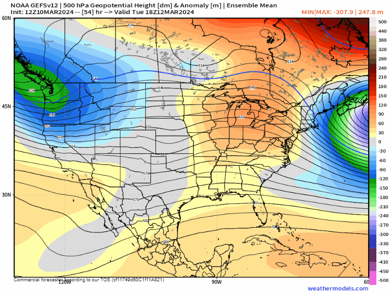
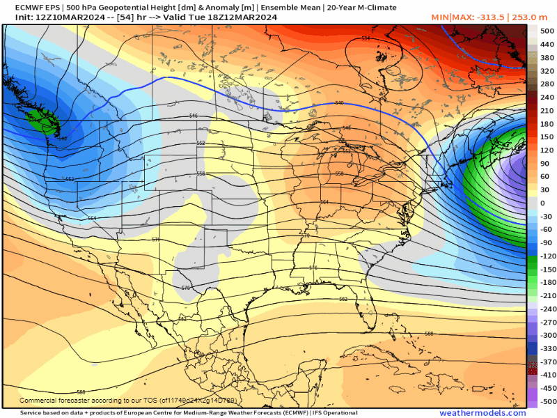
The GEFS solution's difference looks small on this map, but from pure distance standpoint, is nearly 250 miles northeast of its counter-part below. It keeps the main circulation tugged a bit closer to the four-corners, and as a result, has about double the amount of moisture of the EPS which drives the low further southwest.
And I get it, in the grand scheme of the atmosphere, it wouldn't seem like a shift of a 100 miles here or there is going to make much of a difference... but believe us... it will.
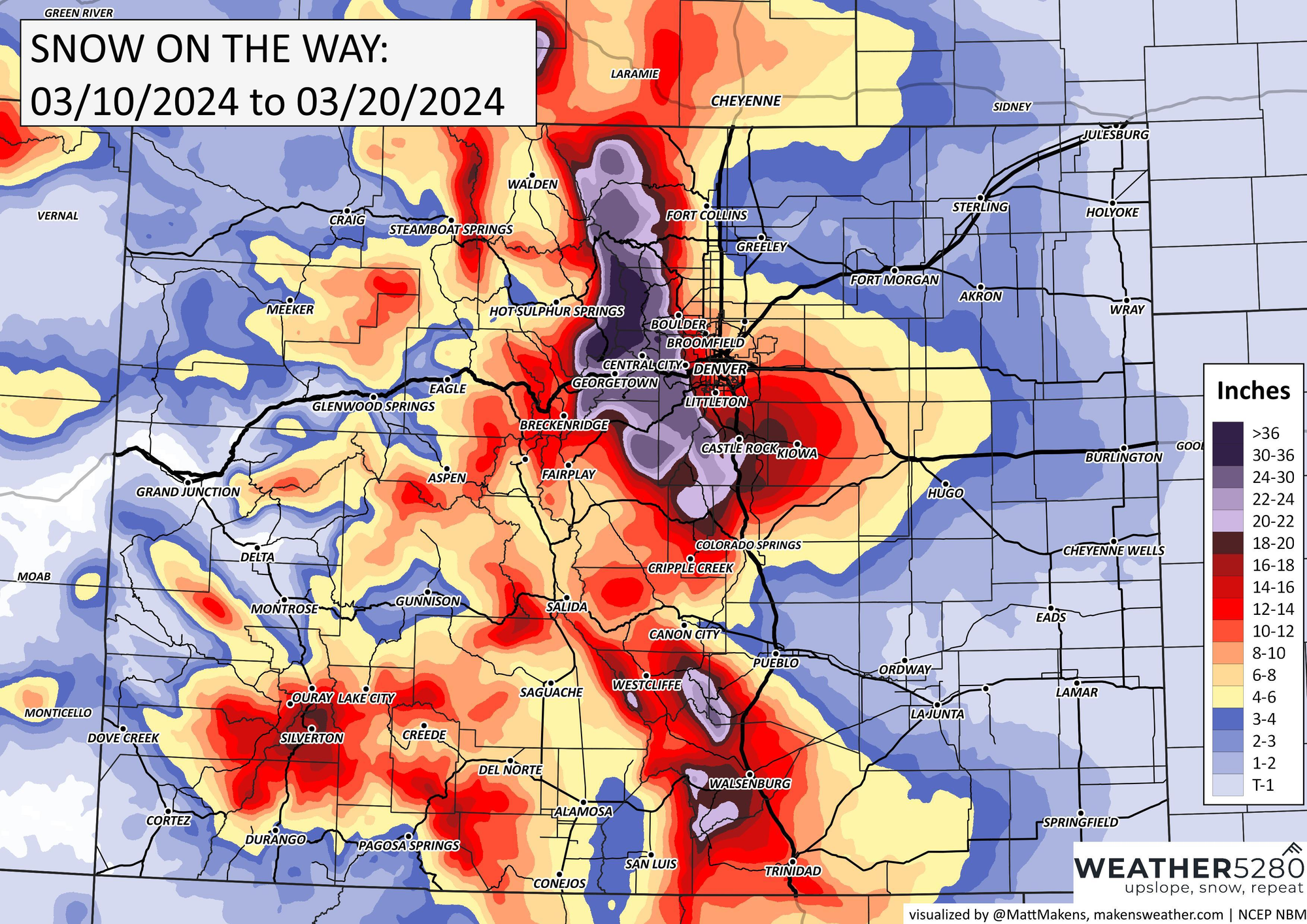
Below is a product from NCEP (National Centers for Environmental Prediction) which blends several different models together to get an averaged estimation of snowfall totals. As you can see, a very clear indication of this storm's potential! While not a forecast, it certainly highlights why are paying attention to this system, especially for the Front Range mountains and foothills.
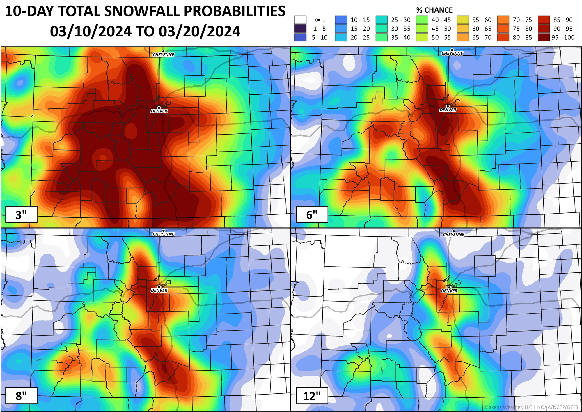
The snowfall probability charts are running hot too, with many along the urban corridor seeing a 50%+ chance for AT LEAST 8" of snow. It also lines up with climatology... and considering it would fall on the 3 year anniversary of the Pi-day blizzard of 2021...
Analog support?
There's definitely some analog support too. Here's the latest odds for 6" of snow or more when measured against the top analogs for later this week. Definitely favoring elevations along and west of I-25, but hard to hate those odds too much if you're eager for a March snow along the urban corridor.
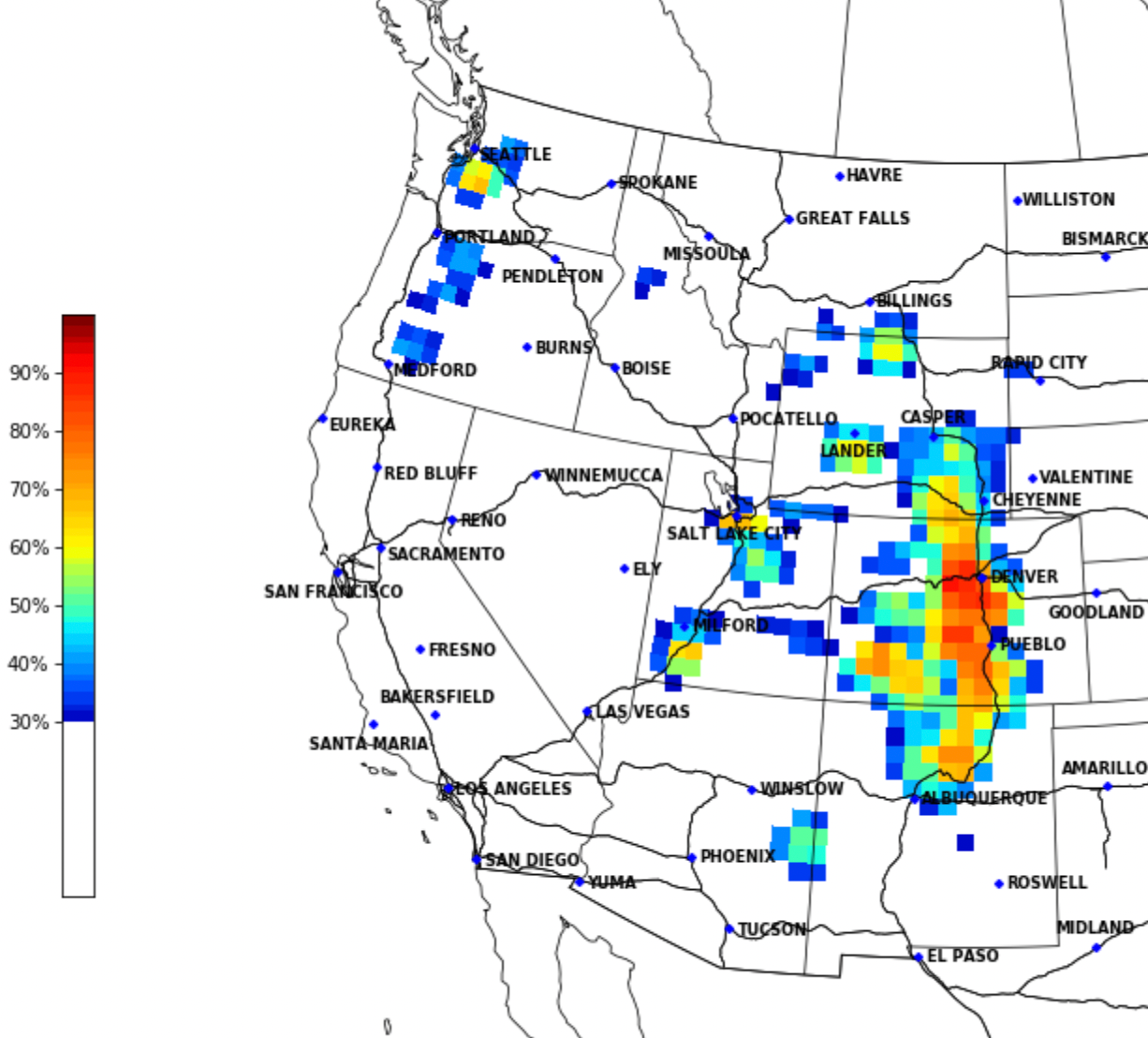
My concern here is again on track, even in many of the top analogs the low track was a bit closer (over over) the Four Corners vs what some guidance has for this upcoming system, but let's see how things trend as we head into the week.
For those wondering: Will this one be a blizzard? Wind doesn't look to be a major factor of this system at this time... but certainly heavy wet snow can cause trouble all on its own.
All we're saying is keep your head up for this one. Lots to iron out and you're going to hear more from us throughout the week!