Significant snowstorm on the way for Denver area, FEET of snow likely for the foothills; Latest snowfall forecast & discussion

We're just hours away from the onset of a significant Colorado snowstorm set to bury the Front Range foothills in feet of snow, and possibly bringing upwards of 12" of snow to the Denver metro area.
Impacts will be greatest at higher elevations west of Denver and Boulder and across the western Palmer Divide, but the cities are looking at a significant snow event as well, and travel from late tonight through Thursday will not be advised, and in all likelihood impossible in some locations as deep upslope gets cranking and heavy, wet snow piles up.
PLEASE plan accordingly, and stay put until the storm clears on Friday.
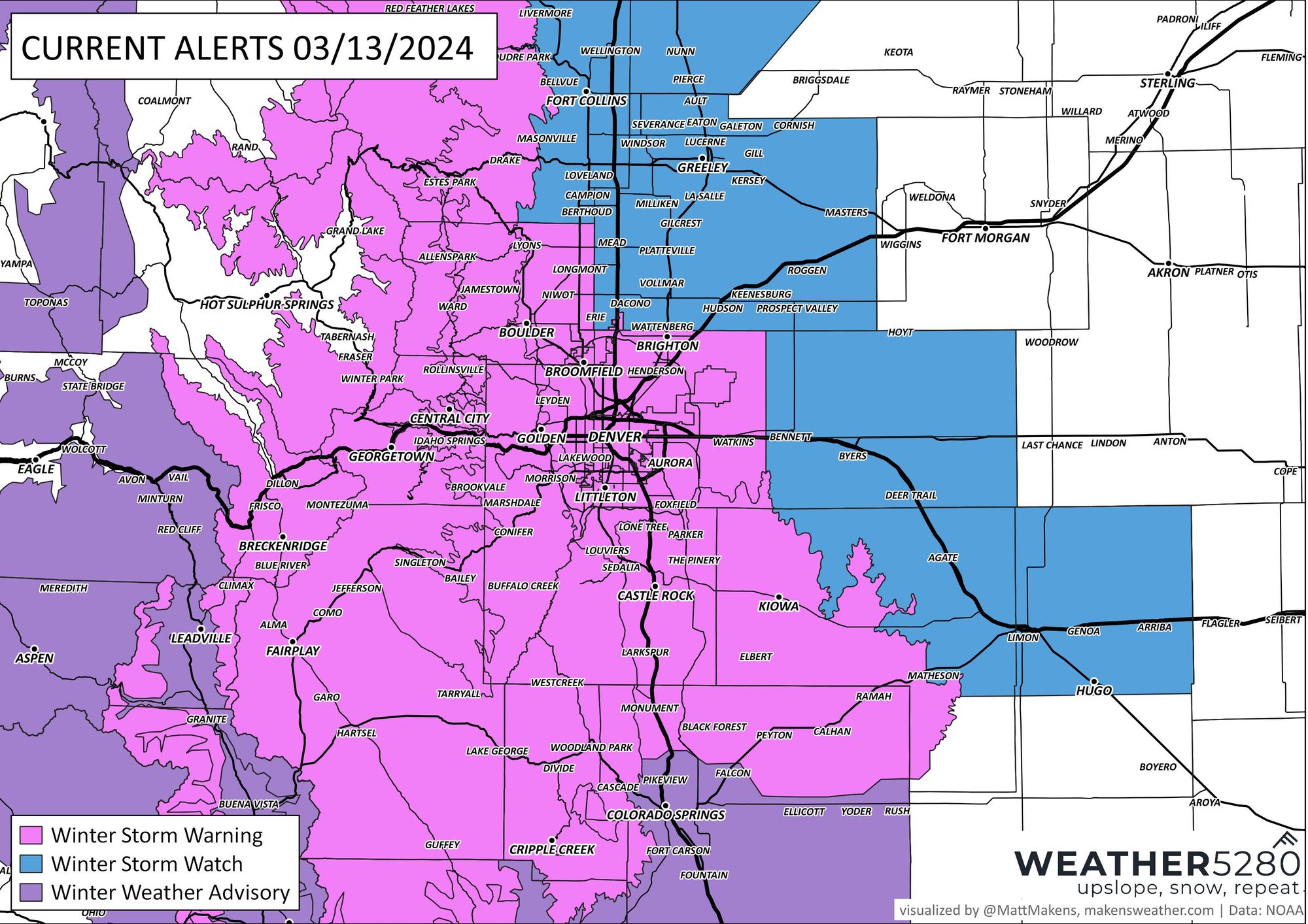
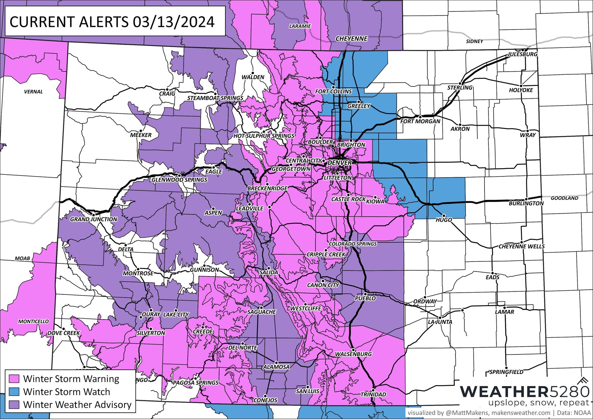
As a reminder, a Winter Storm Warning goes into effect at 9pm tonight for the foothills and Denver metro area. The Warning extends through 6am Friday. Here is a look at the latest alerts from the National Weather Service:
Overall, there are no huge changes to the overall outlook we've been covering for some time now. Rain and snow will increase through Wednesday afternoon and evening, changing to all snow tonight and becoming heavy at times throughout Thursday and Thursday night along the Front Range. Snowfall rates could exceed 3" per hour at times, particularly across the Foothills from tonight through midday Thursday, with 1 to 2" hourly rates for Denver expected Thursday morning.
Some of the biggest questions remaining revolve around how much mixing we'll see at lower elevations before transitioning to all snow (this would impact overall totals) and how much convection plays a role in this evening's weather, in particular where we could see pockets of very heavy snow – and perhaps thundersnow? – during the early hours of the storm. Thundersnow/graupel/rain this evening? Why not indeed.
Thundersnow/graupel/rain tonight, because why not.#9wx #COwx pic.twitter.com/VbT4DuEU75
— Chris Bianchi (@BianchiWeather) March 13, 2024
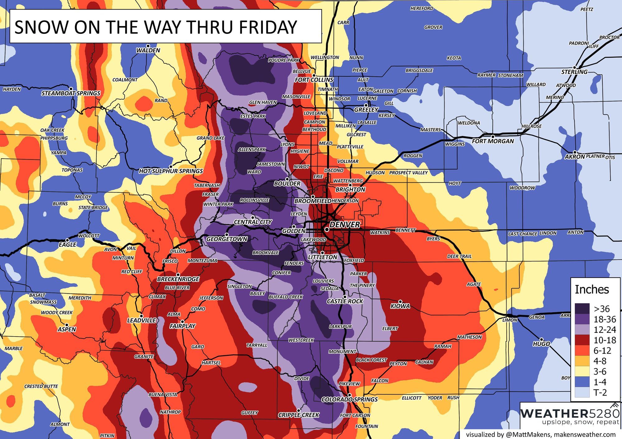
The biggest change to our forecast will be to bring up totals for the Denver metro area, where upwards of 12" looks like a real possibility before things are said and done. Much of today's guidance supports as much as 20" of snow in the city(!!) with lesser totals north and east toward the airport.
The foothills forecast remains largely unchanged. Anywhere from 1 - 3' of snow looks likely here, and this system could produce some 4-foot snow totals. Get ready.
Timeline and impacts
This is a long-duration event! And no matter how much of these we live through... this is worth reiterating, not all the snow will come at once! (though it may feel like it during the height of the storm).
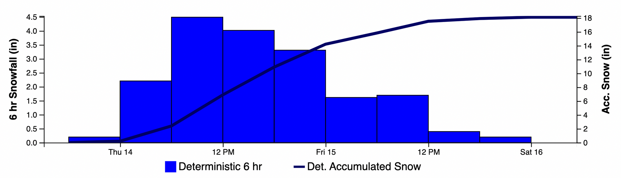
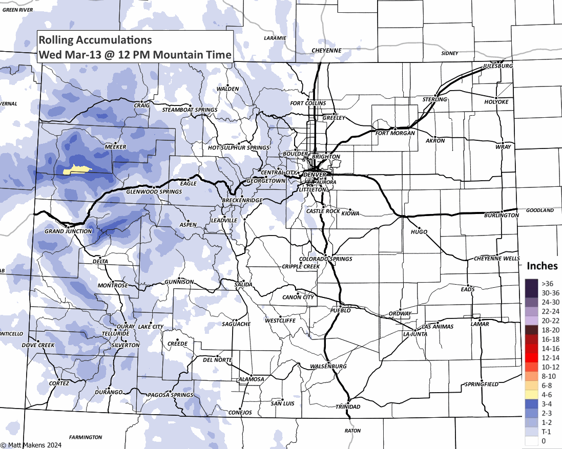
Take for example the blend of models forecast for Centennial. The chart below shows the cumulative total (line) of 18" with the 6 hour totals in the blue bars. The heaviest snow is progged to come during the day Thursday as you can see, so perhaps many of us not waking up to huge totals yet as of Thursday morning – especially east of the hills, but that doesn't mean it's a "bust". Let's wait for the full event to unfold before taking stock on how well the storm performed or did not.
To further that point, watch this animation of snowfall as it accumulates across the area (we will have the snow forecast down below in a few paragraphs):
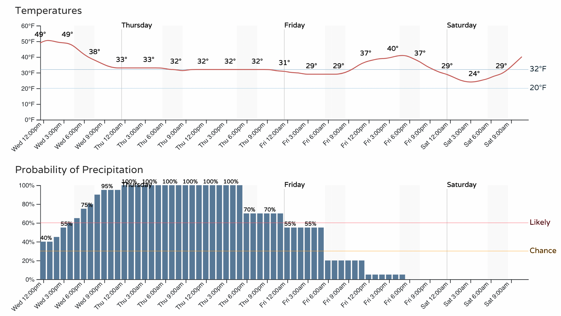
The hourly timeline below shows those precipitation chances really get kicking this evening and carry through all day Thursday before dropping off Friday morning. Temperatures will need to cool a bit this evening before we all transition to snow, but for most of us that should occur before midnight tonight. SNOW (heavy at times!) and temperatures near freezing all day on Thursday:
And no surprise here, but a highly impactful storm across the region on the way – DO NOT TRAVEL Thursday. Also, given the heavy snow and amount of snow expected, scattered power outages across the region will be a concern as well. Here's the latest impact map for the incoming storm:
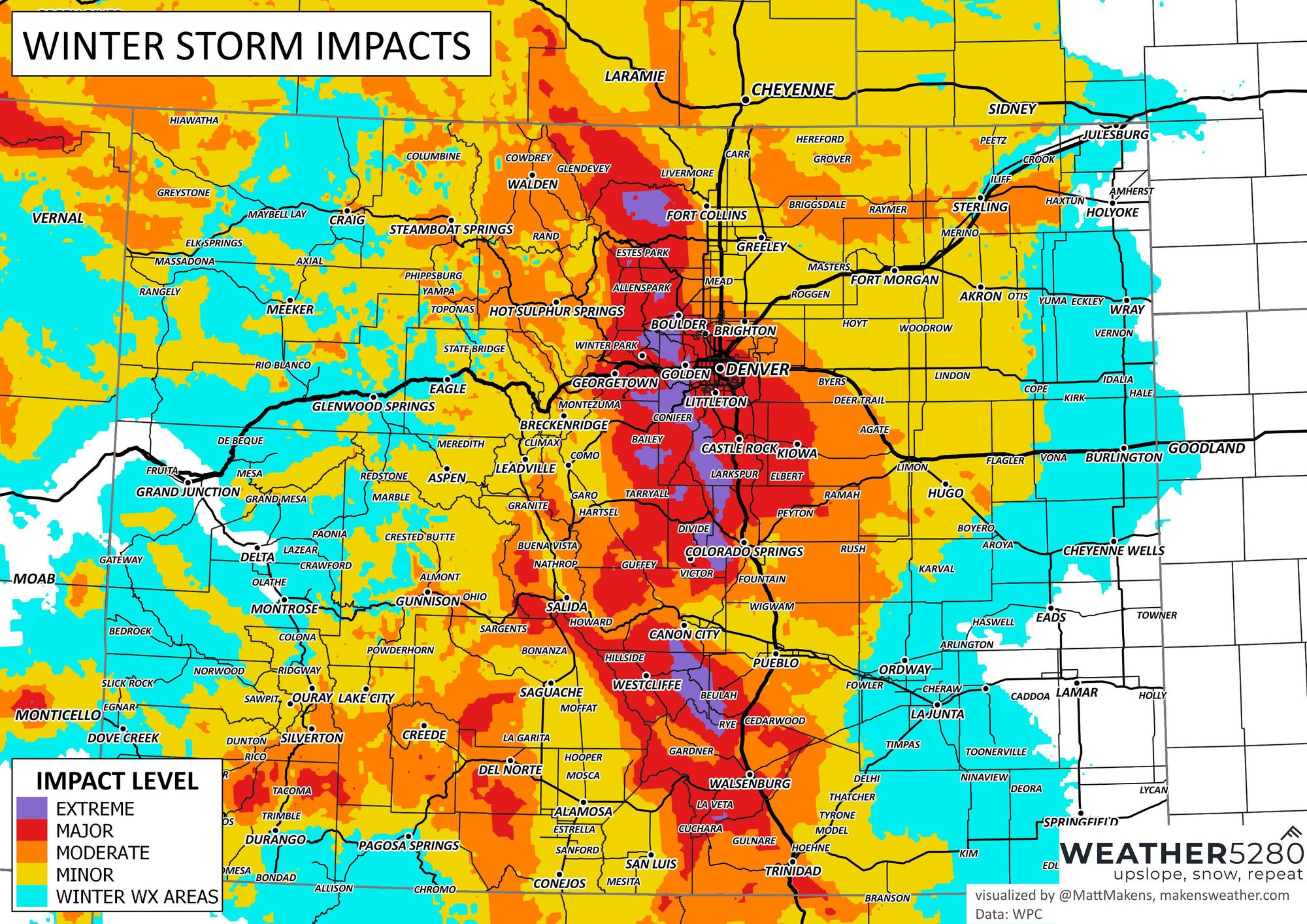
A good reminder of the above from the NWS this morning:
Heavy snow in/near the Front Range Mountains, Foothills 🙴 Palmer Divide. Storm totals will range from 1-3 feet in the mountains/foothills (locally up to 4 feet) 🙴 Palmer Divide, with 8-20 inches over the Greater Denver-Boulder area. #COwx pic.twitter.com/rgGIbxMRbr
— NWS Boulder (@NWSBoulder) March 13, 2024
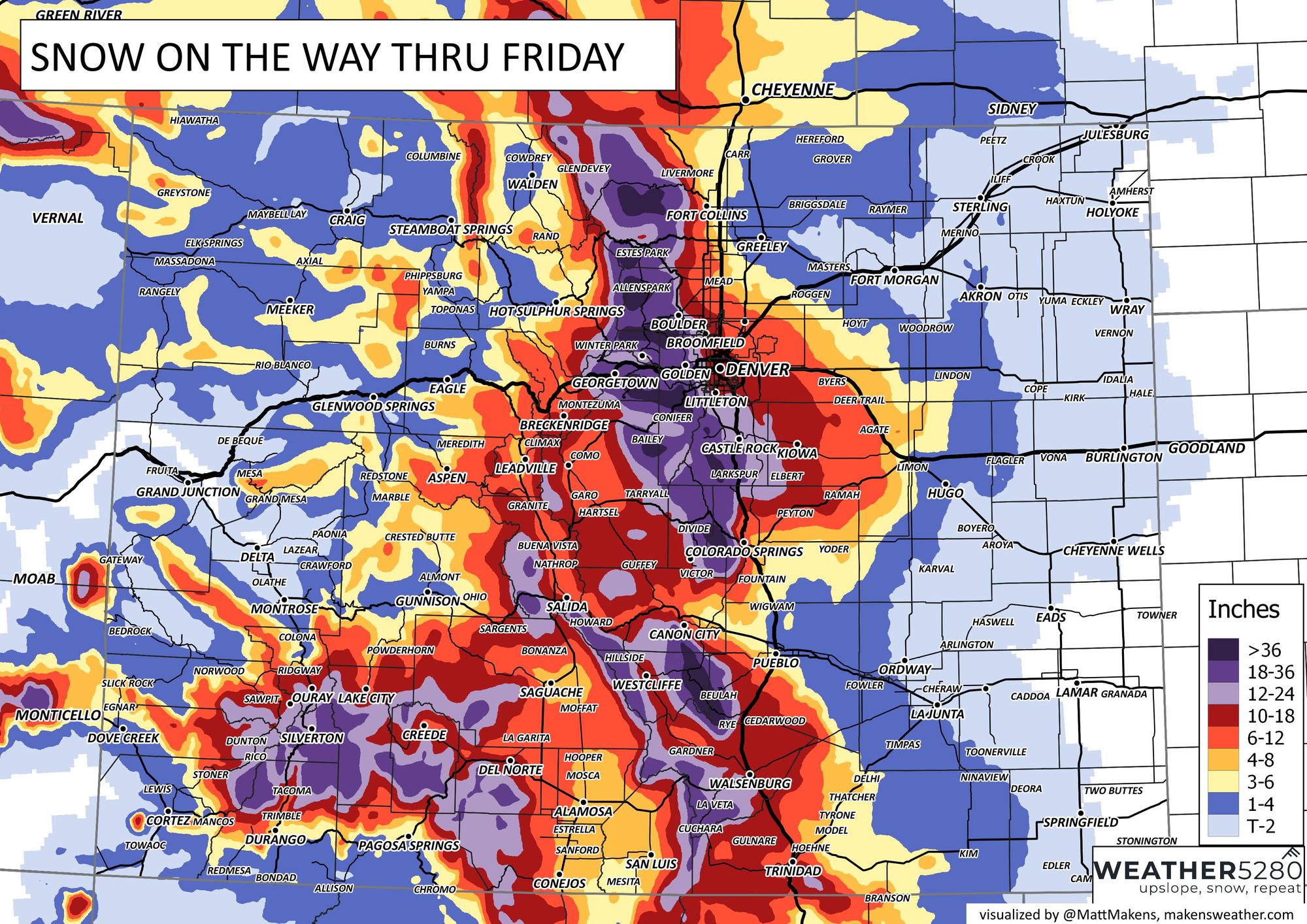
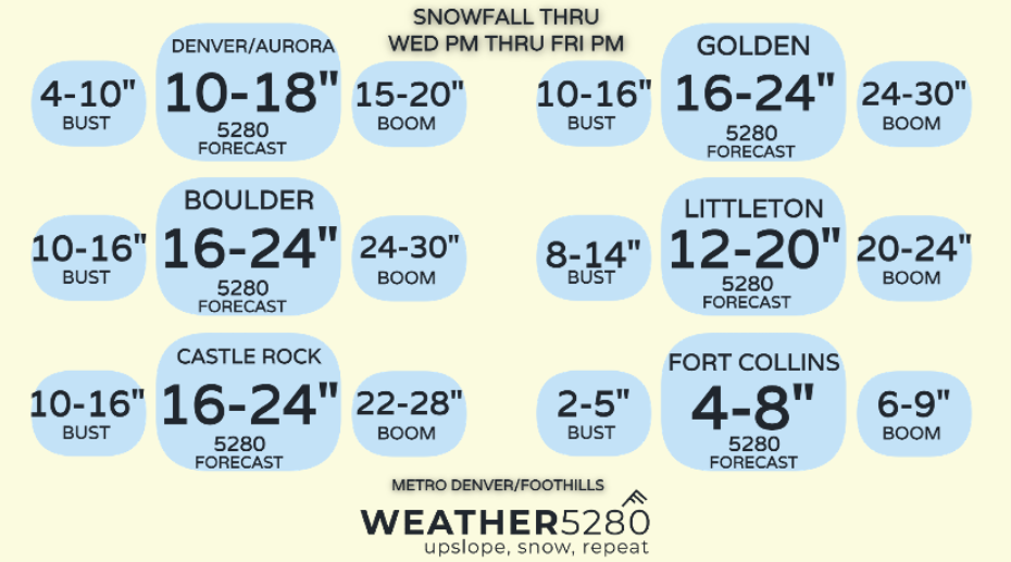
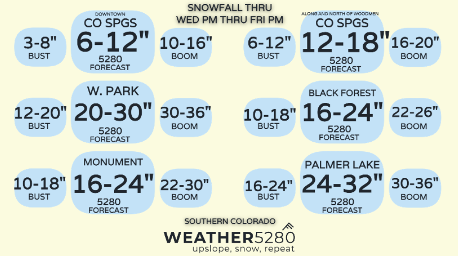
Snowfall forecast
It's going to be a heck of a storm for some communities along the urban corridor, and especially those in the hills to the west. Here are the latest forecast maps and boom + bust potentials for select cities across the region.

Final thoughts ahead of the storm
As many of you have pointed out, this is in many respects an atypical setup for what we look for as that classic March storm along the Front Range. Still, in many respects it absolutely is, and it looks like all the right ingredients are aligning to deliver a wintry wallop to the region – and for some the biggest snow in years.
As with all storms this one will surely have some surprises ahead. Will that be in the form of a boom? bust? something else? Time will tell. There's a ton of moisture headed our way, with deep upslope against the Rockies giving all the makings for some pretty fun weather here over the next 24 to 48 hours.
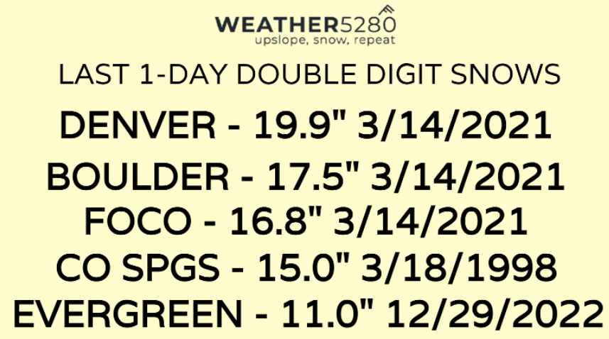
A look at previous 1-day double digit snowfalls:
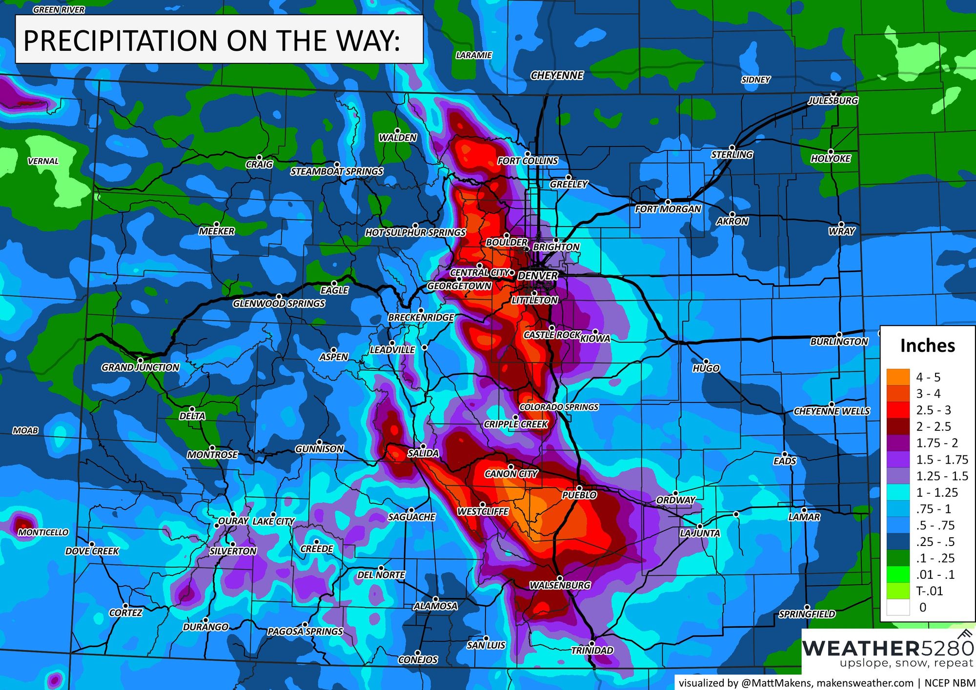
Total water from this event is estimated as:
We look forward to ALL of your reports (and pictures!) so please share those in the comments below.
Finally, what are your predictions for your backyard? Please share your town/city and the amount of snow you think you'll get in the comments below!
As always, please subscribe!