Running list of snowfall totals as monster March snowstorm wallops Front Range of Colorado

The much anticipated storm arrived overnight and has already buried parts of the Front Range under feet of snow with another 12 to 24 hours to go! While parts of the metro area fell victim to mild temperatures and prolonged rain/mixing last night, the majority of folks have already hit the low-end of their forecast range, and most of us that haven't should get there before things are said and done Friday morning.
Overall, no changes to the ongoing forecast. We'll see a lull in the action today before things ramp up again Thursday afternoon and evening, with snow gradually coming to an end by Friday morning.
If you are looking for our latest forecast numbers and timeline, please see this update below:
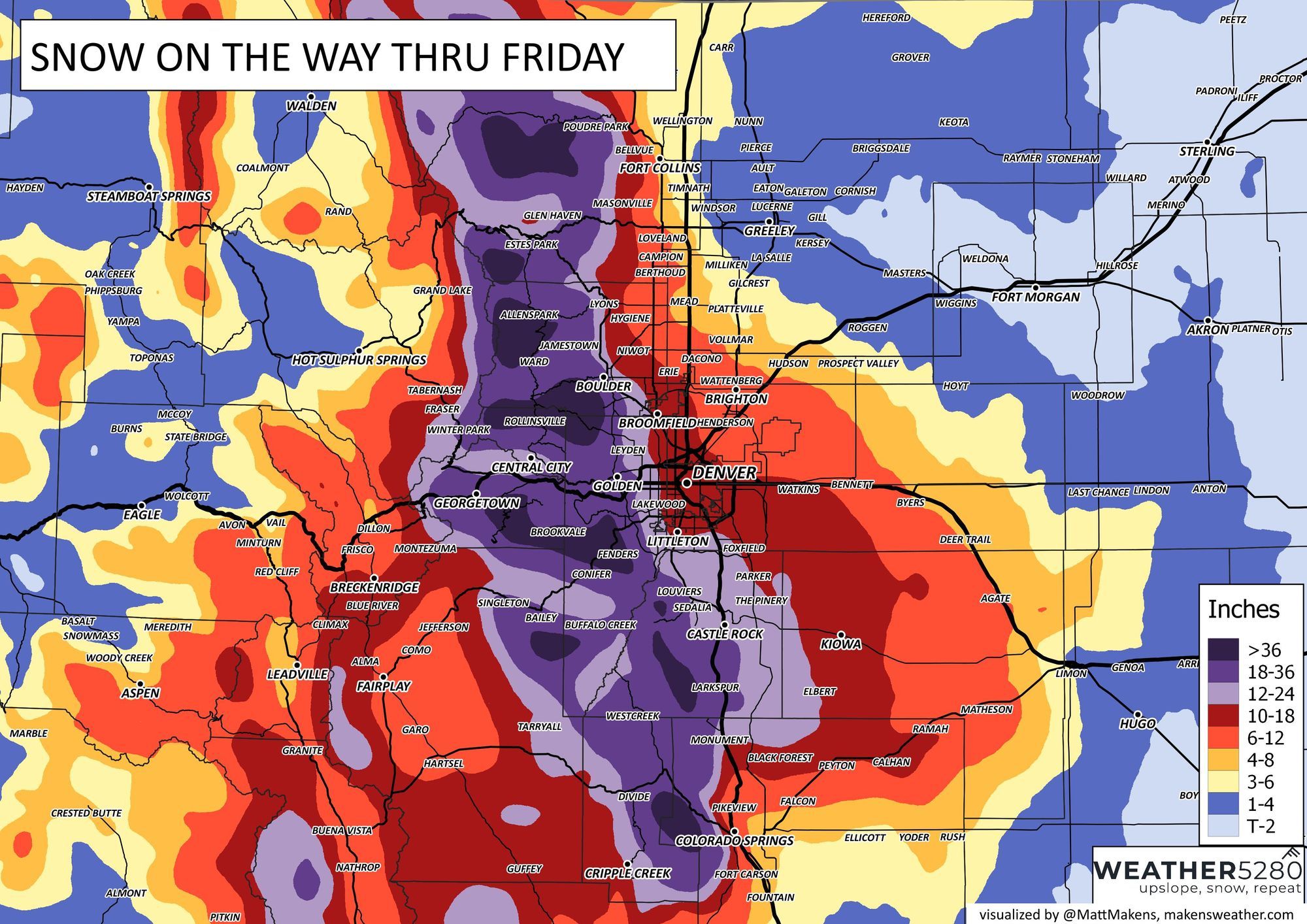
Here's a map of additional expected snowfall from 2pm Thursday through Friday morning:
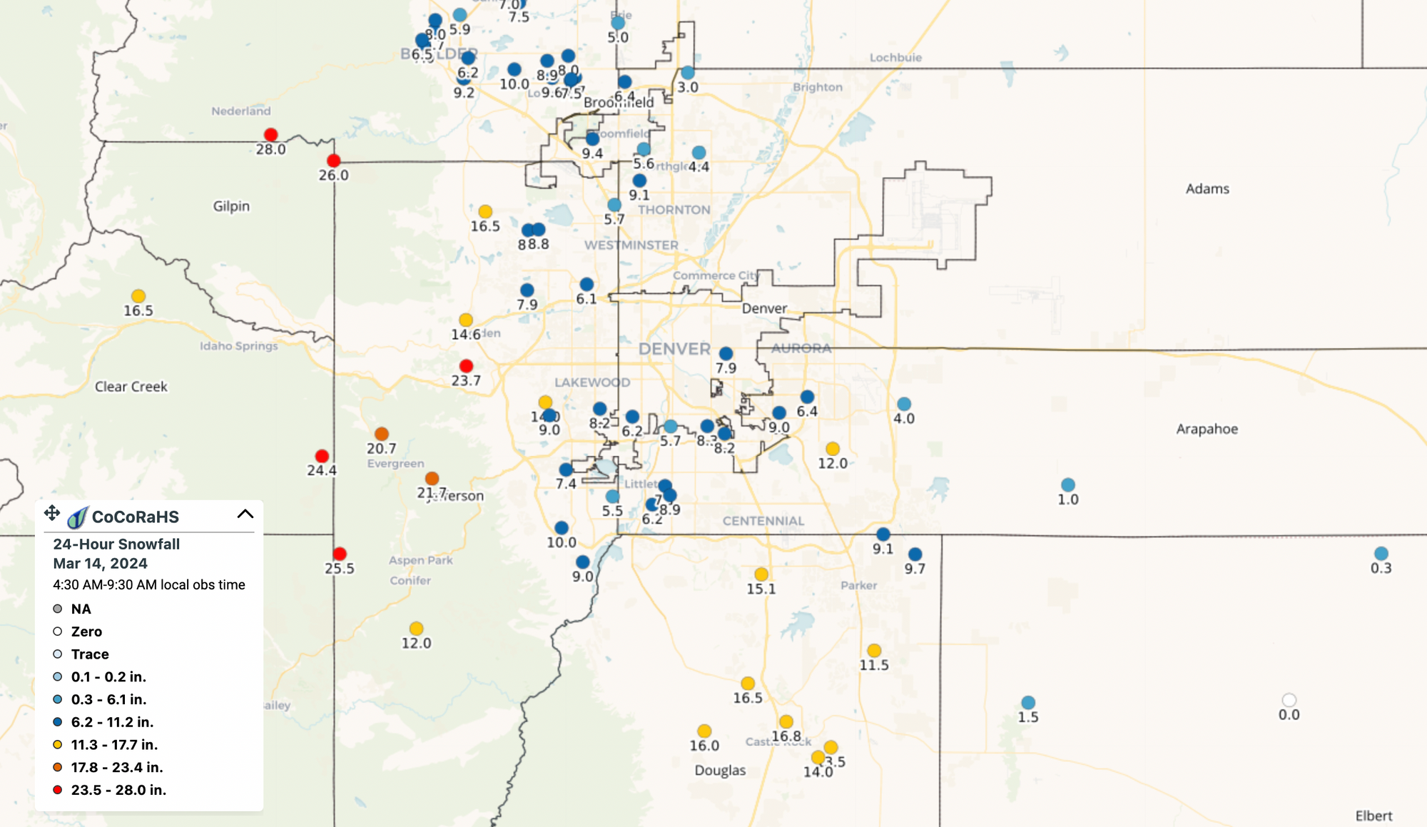
Below is a list of snowfall totals from across the region. We will continue to update these through the duration of the storm. And, as always, please add your storm reports (and photos!) in the comments below! We really enjoyed all the interactions last night.
Snowfall for Denver
Official Denver recorded, so far, 2.3" from this event at DIA through 6pm. What a shame it'll be when the official record does not reflect this storm's actual impact across the city's population core, but at least we've finally broken the 2" mark!
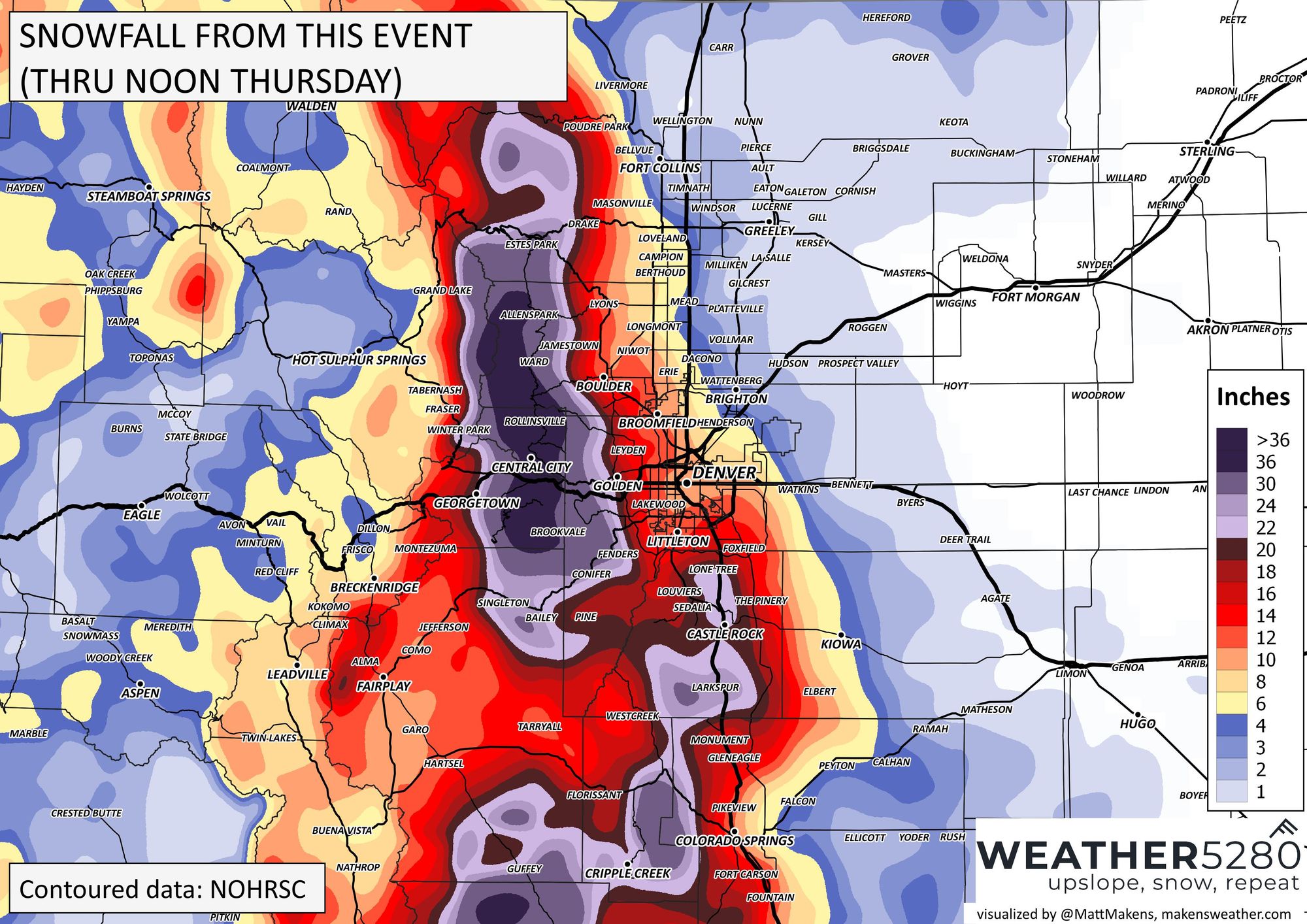
As we've been discussing for days, the big-time winners so far are the foothills west of town and the Palmer Divide. Totals have climbed into the feet...
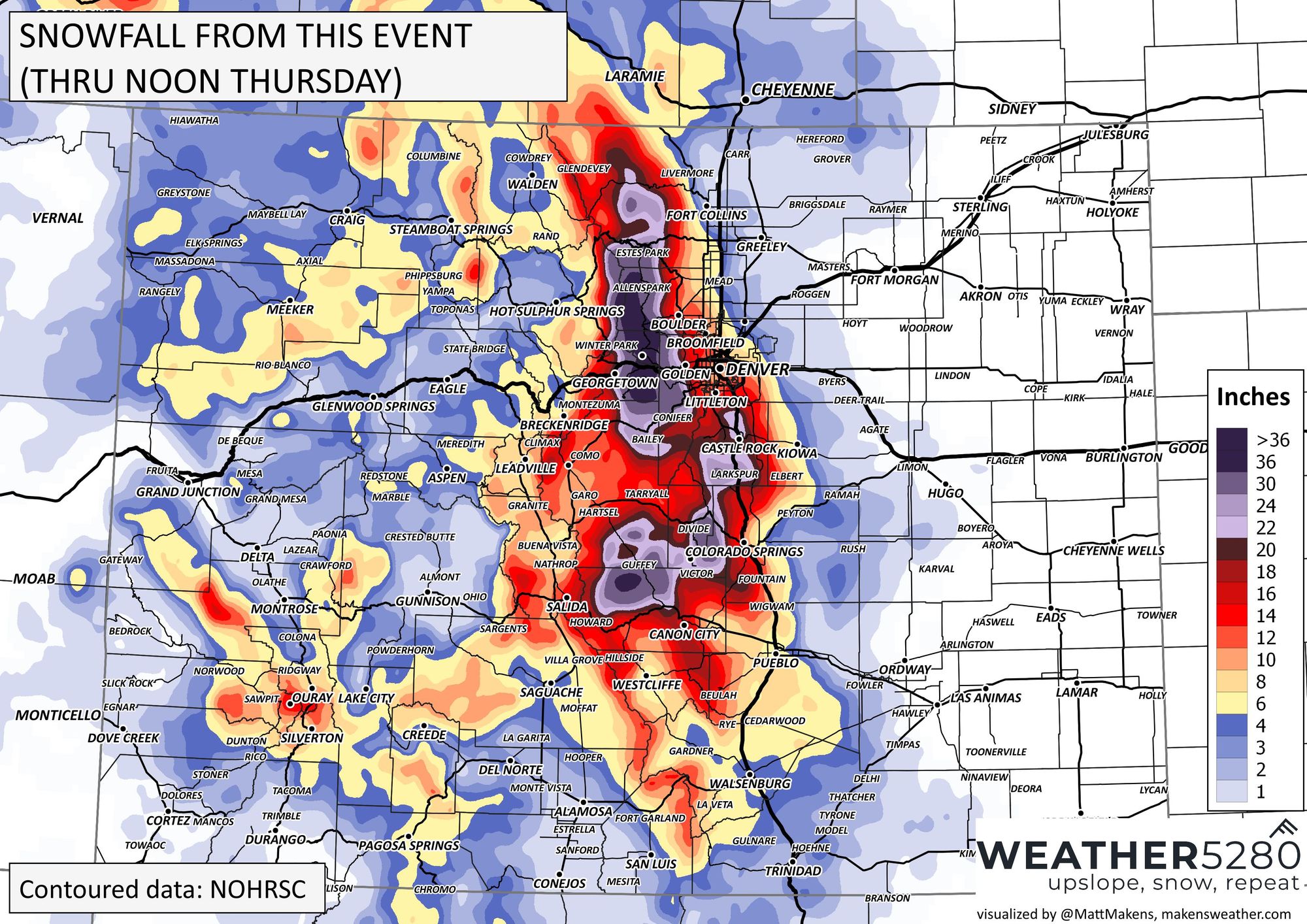
Snowfall totals through noon Thursday:
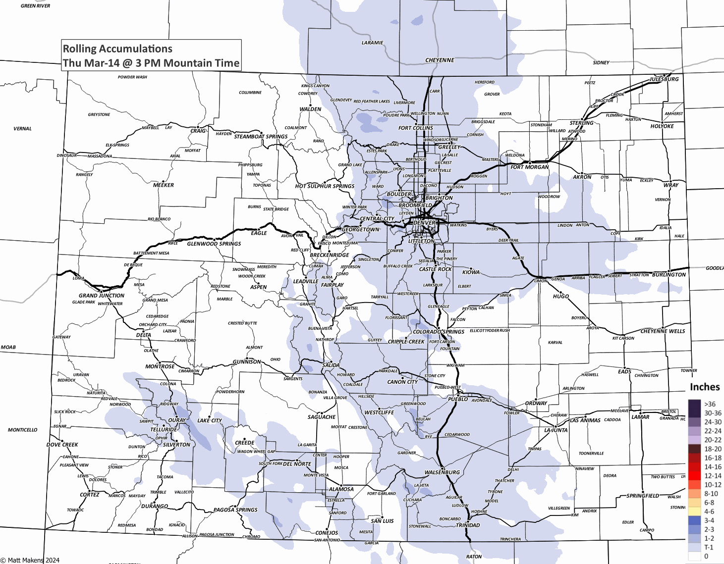
Map of totals received in the last 12 hours (updated 7pm Thur). Look at DIA with 2.3" finally!
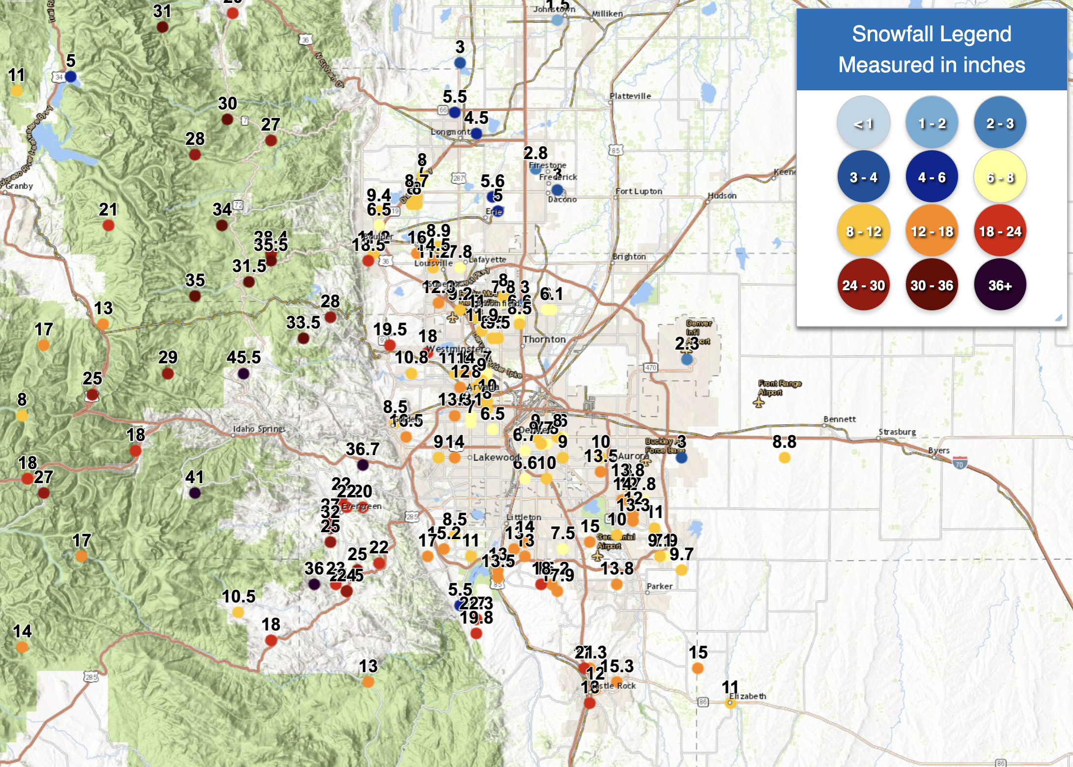
Reports made during the last 12 hours (updated 7pm Thur.)
02:16 pm EDT - 3/14/2024 1 W Aspen Springs, CO 45.5"
03:00 pm EDT - 3/14/2024 1 NNE Echo Lake, CO 41
06:02 pm EDT - 3/14/2024 1 NNW Genesee, CO 36.7
12:23 pm EDT - 3/14/2024 4 W Conifer, CO 36
03:15 pm EDT - 3/14/2024 4 ENE Nederland, CO 35.5
06:00 pm EDT - 3/14/2024 1 WSW Eldora, CO 35
03:00 pm EDT - 3/14/2024 3 SE Brainard Lake, CO 34
02:18 pm EDT - 3/14/2024 4 SSE Pinecliffe, CO 33.5
10:59 am EDT - 3/14/2024 2 S Evergreen, CO 32
11:30 am EDT - 3/14/2024 1 ESE Nederland, CO 31.5
04:00 pm EDT - 3/14/2024 Bear Lake, CO 31
10:56 am EDT - 3/14/2024 1 SSW Allenspark, CO 30
08:23 pm EDT - 3/14/2024 1 SSE St Marys Glacier, CO 29
11:45 am EDT - 3/14/2024 4 NE Nederland, CO 28.4
03:00 pm EDT - 3/14/2024 3 NNE Mt Audubon, CO 28
01:27 pm EDT - 3/14/2024 1 NNE Estes Park, CO 28
12:39 pm EDT - 3/14/2024 1 SSW Crescent Village, CO 28
09:21 am EDT - 3/14/2024 1 N Raymond, CO 27
04:00 pm EDT - 3/14/2024 1 SE Loveland Pass, CO 27
06:00 pm EDT - 3/14/2024 1 SSE Evergreen, CO 27
04:00 pm EDT - 3/14/2024 Berthoud Pass, CO 25
12:53 pm EDT - 3/14/2024 3 S Evergreen, CO 25
01:06 pm EDT - 3/14/2024 1 NE Aspen Park, CO 25
11:10 am EDT - 3/14/2024 Conifer, CO 24
11:05 am EDT - 3/14/2024 2 WNW Conifer, CO 23
04:20 pm EDT - 3/14/2024 1 SE Kassler, CO 22.3
10:27 am EDT - 3/14/2024 3 ENE Aspen Park, CO 22
09:40 am EDT - 3/14/2024 1 SW Kittredge, CO 22
09:40 am EDT - 3/14/2024 1 WSW Kittredge, CO 22
10:15 am EDT - 3/14/2024 1 WSW Conifer, CO 21.5
01:33 pm EDT - 3/14/2024 3 NNW Castle Rock, CO 21
03:00 pm EDT - 3/14/2024 6 WNW Arapahoe Peak, CO 21
09:20 am EDT - 3/14/2024 2 S Estes Park, CO 20
09:30 am EDT - 3/14/2024 2 SE Kittredge, CO 20
01:15 pm EDT - 3/14/2024 2 N Roxborough Park, CO 19.8
01:09 pm EDT - 3/14/2024 2 SSW Rocky Flats, CO 19.5
05:54 pm EDT - 3/14/2024 3 SSW Boulder, CO 18.5
03:00 pm EDT - 3/14/2024 4 WSW Trail Ridge, CO 18
11:10 am EDT - 3/14/2024 2 SSE Highlands Ranch, CO 18
10:00 am EDT - 3/14/2024 1 S Castle Rock, CO 18
08:00 pm EDT - 3/14/2024 3 SE Rocky Flats, CO 18
04:00 pm EDT - 3/14/2024 2 NW Loveland Pass, CO 18
10:00 am EDT - 3/14/2024 1 N Georgetown, CO 18
01:59 pm EDT - 3/14/2024 3 NNE Bailey, CO 18
11:30 am EDT - 3/14/2024 2 WSW Lone Tree, CO 17.9
11:00 am EDT - 3/14/2024 2 NNW Castle Rock, CO 17.3
01:35 pm EDT - 3/14/2024 1 WSW Ken Caryl, CO 17
10:16 am EDT - 3/14/2024 1 ESE Kassler, CO 17
03:00 pm EDT - 3/14/2024 5 WSW Guanella Pass, CO 17
10:45 am EDT - 3/14/2024 Georgetown, CO 17
Southern Colorado
07:00 am MDT - 3/14/2024 3 W Black Forest, CO 7.8
07:00 am MDT - 3/14/2024 5 W Falcon , CO 6.0
07:00 am MDT - 3/14/2024 3 ENE Manitou Springs CO 6.0
07:00 am MDT - 3/14/2024 2 NNE Colorado Springs, CO 7.0
08:30 am MDT - 3/14/2024 5 S Air Force Academy 6.0
08:45 am MDT - 3/14/2024 2 SSW Great Sand Dunes 8.0
10:08 am MDT - 3/14/2024 10 NNE Silver Cliff, CO 12.0
10:08 am MDT - 3/14/2024 3 NE Rosita, CO 18.0
07:00 am MDT - 3/14/2024 Palmer Lake, CO 15.2
07:00 am MDT - 3/14/2024 5 E Monument, CO 14.8
07:00 am MDT - 3/14/2024 3 NE Cripple Creek, CO 16.0
08:00 am MDT - 3/14/2024 2 N Woodland Park, CO 18.5
Again, please add your observations below! And we'll keep updating this post through the remainder of the storm.