El Niño Update and Forecast

We all remember what happened last year at this time. There was a lot of talk about a Super El Niño getting ready to occur. That certainly didn't come to pass, and we talked a lot about why we didn't think that would happen here at Weather5280.
Here we are again a year later, and the same talk is occurring. I am not ready to completely sign off on a strong event, or even a moderate event occurring. However, I am more intrigued by the setup this year and the potential event that is occurring and/or set to occur.
Current Status:
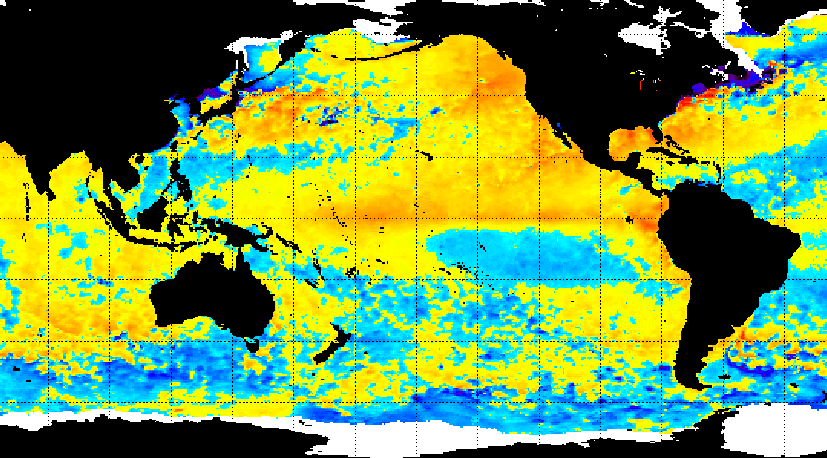
The Pacific Ocean is warm and has been for over a year. The map below shows the global sea surface temperature anomalies:
Here is a another map that shows the various phases of the Pacific Ocean, both PDO and ENSO:
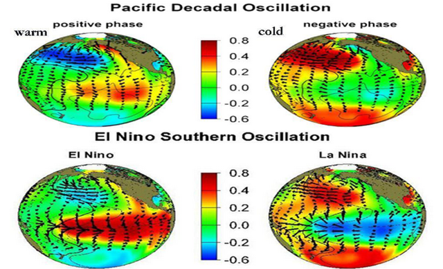
As you can see we are in a very positive PDO phase right now. During the past 5 months, the PDO has averaged a whopping 2.20! Records were set during December, January, and February as the highest PDO indices on record for those months. We talk a lot about the PDO because it is a huge player in governing our weather and climate. Also, you can see that we are currently experiencing an El Niño episode. To be honest, we have been experiencing an El Niño episode for quite a while, just not the traditional kind. We have been in a California Niño state and a Modoki state for quite a while. You've heard me talk about Modoki El Niño before, but for those that haven't here is what one looks like:
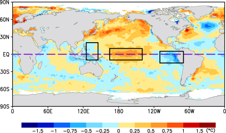
Notice that during a Modoki El Niño, the warmest water favors the western ENSO regions. If you look at the chart below, you can see that we favored Modoki El Niño conditions for most of the winter months. From late December through March, Niño Regions 3.4 and 4 were noticeably warmer than Niño Regions 1+2.
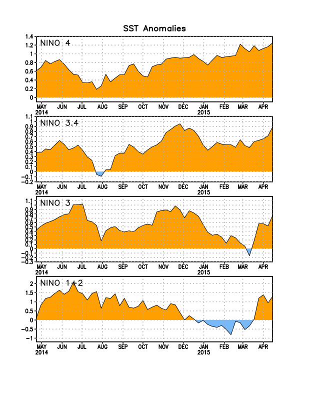
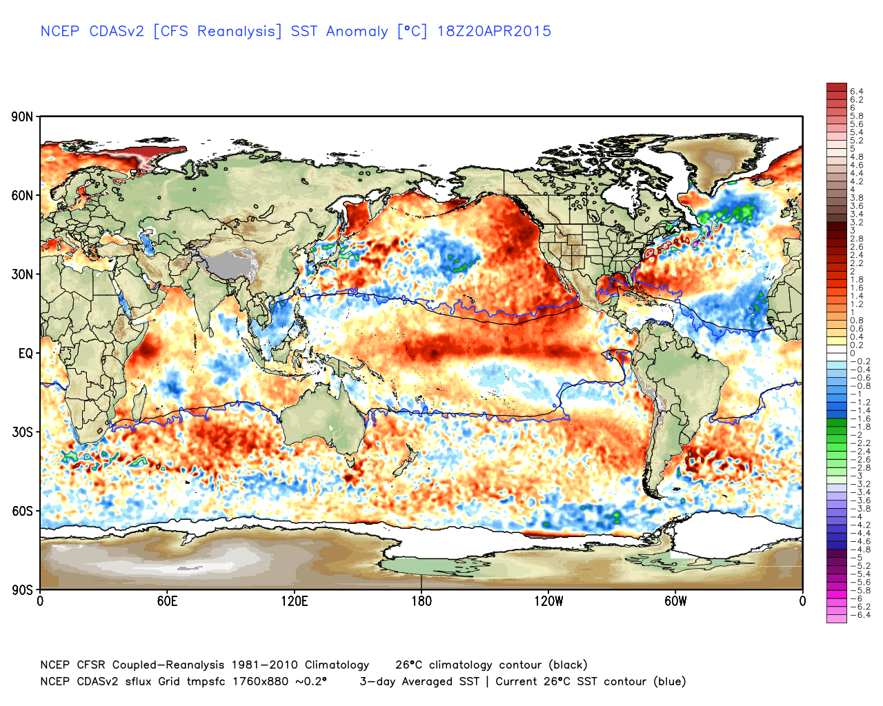
Recently, the trend has been to warm all Niño Regions (and in my opinion) has transitioned from a Modoki event to a more traditional El Niño event. Again, look at the sea surface temperature anomaly map.

You can easily see the lingering Modoki warm pool in the equatorial western Pacific. However, you now see the warmer than normal water across all of the equatorial Pacific Ocean. That is what a more traditional El Niño looks like...
The Models:
Here is a look at what the various models are forecasting in terms of how the current El Niño is going to play out:
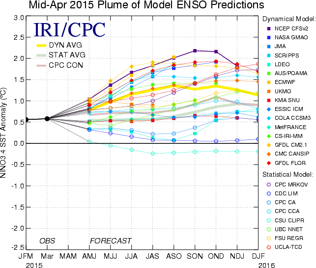
Any model forecast (individual line) that goes above 0.5 and stays there for 3 consecutive months or longer, is technically forecasting an El Nino. You can see that the majority of the lines are well above 0.5, and stay there for the remainder of 2015. A few of the models remain at or below 0.5. Due to the many collassal model errors of 2014 in ENSO forecasting, one should not discount the models that are forecasting a lesser or non event.
One model that I do favor more than the others when it comes to long range forecasting, is the JAMSTEC model. It has had the California Nino pegged for quite some time. It did a nice job forecasting the Modoki event that persisted for the winter. It is also doing a nice job forecasting the transition from that Modoki event to a more traditional El Nino. Below are the JAMSTEC sea surface temperature anomaly forecasts from the March model run (new run due any day):
March-May
June-August
September-November
While this El Niño event may be a bit more like a traditional event, there is still something that doesn't necessarily sit well with me in terms of potential impacts. Aside from June - August, the JAMSTEC continues to favor the warmest water in the western Nino Regions. This has a more hybrid (central Pacific based El Nino) feel to me. In fact, it could possibly go back to a more Modoki looking event by the end of the year. Tough to say at this point, but the event and evolution of the event doesn't necessarily fit the traditional mold. The 1997-98 Super El Niño was in fact a traditional El Nino and looked like this:
Notice that the warmest water with that El Niño favored the eastern equatorial Pacific. So, I am cautious in not only the type of El Nino that will take hold and persist, but also the potential impact of such an event.
Probably the most noteworthy thing of the JAMSTEC model, is the fact that the PDO is likely going to remain in a very positive state through the end of 2015. To me, the very positive PDO working in tandem with whatever type or strength of El Niño persists may be the true tell as to what type of weather we may have. I am working on some analog years to use as a guide for the rest of the spring, summer and fall. So far I have come up with: 1940, 1941, 1958, 1959, 1978, 1987, 1994, 2003, and 2014. There are likely some others in there that I am missing, but you get the idea. Meaning, the weather that occurred from March - November of those years may very well be a nice roadmap to what will happen for the rest of 2015. I will share more of that with you in a later post, but here is what the March run of the JAMSTEC suggested for the the rest of 2015:
Temperatures
March-May:
June-August:
September-November
Precipitation
March-May:
June-August:
September-November:
The JAMSTEC continues to forecast cooler than normal conditions for the rest of spring and summer for Colorado. While I think it may be a bit erroneous for the rest of spring in terms of temperature, I think it may be on to something for the summer. It is also forecasting wetter than normal conditions for the rest of spring and summer, before drying out in the fall. With all the warmer than normal water in across the Pacific basin, I expect the Pacific will have a very active hurricane season. I think this is especially true for the Eastern Pacific. This could enhance our monsoon season, and give us more to worry about in terms of flash flood potential. Also of note is the temperature pattern of September, October, and November that is being forecast by the JAMSTEC. Does that look familiar or what?! Very similar to what happened in 2014 and early 2015. Western ridge, eastern trough that is caused by the very positive PDO...
Look, it is tough to say what type of El Niño event will persist and at what strength for the rest of 2015. However, I am leaning toward this event not being a Super El Nino. I actually think it may max out as a moderate event from now through the summer as a more traditional type El Niño, then go back to a more Modoki look this fall and winter. The JAMSTEC is hinting at this, and I really like that that forecast. And regardless of what type of El Niño we experience through the summer, the PDO will remain positive for quite a while longer. This will remain a driving force in our weather. I have some thoughts that go beyond this timeframe, but will leave those for a different post.