The Weekend Is Here, and so Is "Quieter" Weather

We made it to the weekend...saweet! Now, should we plan on wet weather, or some good outdoor playtime?
The good news is that this weekend's weather will be very similar to today's. That means scattered mountain storms and isolated foothill and Front Range storms. Temperatures will warm-up a touch more, too.
I'd say the most weather-aware area will need to be the southwestern mountains. This area is likely to see the most thunderstorms, yet it will still be a beauty of a weekend.
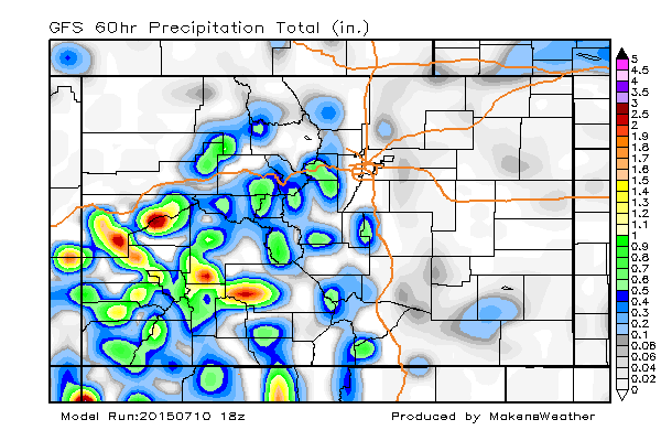
Here's a look at the areas to potentially get some rain. The amounts remain "light" throughout the weekend period, with the exception of the southwestern/western mountains.
In the mountains:
Expect daily thunderstorms, with the usual mid-morning start time and lasting through the day. Hikers, start early as you normally should. 60s and 70s are expected throughout the high country with a 20-40% storm chance daily. The wind may be a drawback from time to time.
Fishermen...I hear the Yampa has some great catches recently. Eh-hem.
For the metro areas:
Warming temperatures will be here through Sunday. Today's high was 85, we'll add about 3 for Saturday, and another three for Sunday. So, the metro areas are likely to hit the 90s before the weekend is over.
There will be some storms, but a similar coverage to today's; 10-20% chance of getting stormed on this weekend during the normal afternoon and evening timeline.
Have a great weekend. Should a storm pop-up, I'll post updates here and via twitter at both @Weather5280 and @MattMakens247wx. We'll be taking a look at next week's forecast in Sunday's State of the Atmosphere.