
The State of the Atmosphere: Sunday, August 30, 2015

As I sit to write this week's SOTA I can't believe August is already coming to an end. I just tried to make plans with the family for Halloween! Let's hope the weather pattern gets a bit more active between now and then. In the short-term there isn't a lot of change coming.
This past weekend tallied up days 40 and 41 of 90+ degree heat, and we will add more to that this week. The sad thing is that we do need rain, but can't seem to "buy" any. Through Sunday, we are 0.59" drier than average at DIA for August. The only hope for late August rain comes with a relatively weak system to graze the state tonight and Monday.
This trough was pretty deep over the Western US, but now is flattening a bit as it pushes east. We will be grazed by it for Monday. There will be a few storms here-and-there, but not a good chance of the moisture we need. Temperatures will also cool a touch, down into the middle and upper 80s. August will end at about a degree warmer than average.
This trough sure doesn't last long; it moves out Tuesday. The first few days of September warm to near 90 and above with a mostly dry forecast.
The consensus is pretty strong on the forecast through Thursday, but there is a bit of variety starting next weekend. MOS indicates a significant cool-down coming Sunday and Monday. However, that same time period appears less impressive in the ECMWF Ensemble temperatures which shows only another modest cool-off.
I hate to disagree with the ECM, so I won't. There is little support of a pattern change in the teleconnections. The Pacific looks to keep moderate temperatures with a northwesterly storm flow over the western U.S. for days 10+.
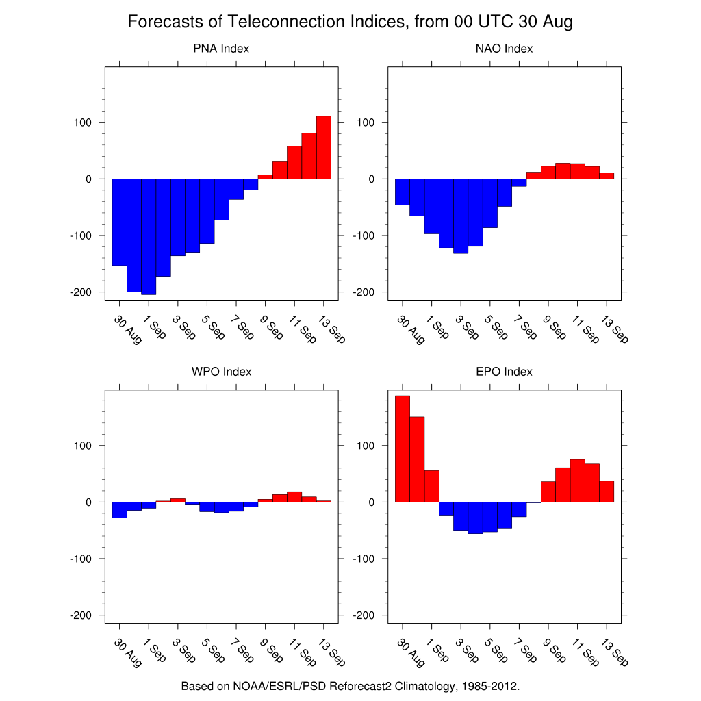
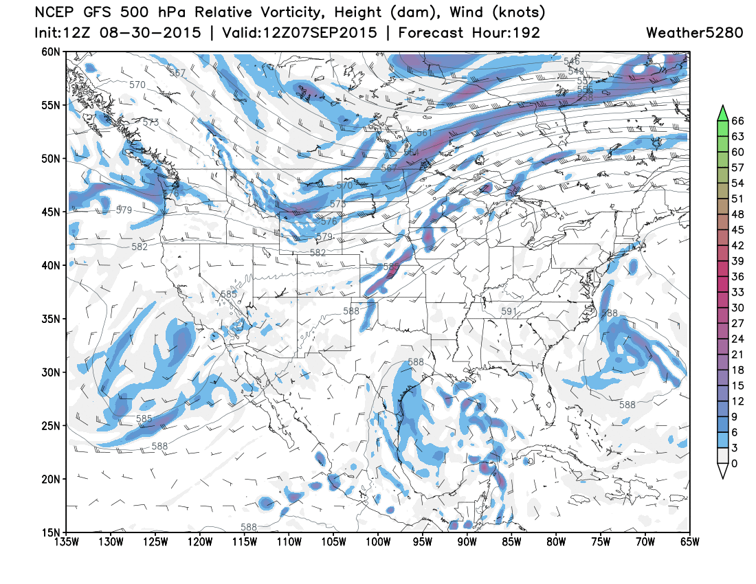
GFS will likely remain "optimistically" calling for a colder/wetter pattern in the next few runs in its MOS. Although, the GFS 500mb height pattern doesn't support the cold temperatures that are suggested in MOS. So, the two will work through that the next few runs.
There is some indication in the CFSv2 modeling to support a colder pattern shift. I'd like to see the ocean indications trend that way before I begin to believe. There are chances for the second and third week of September to be more active, cooler and wetter.
For the time being I think we will just see these quick grazing troughs with noticeable, yet minor, impacts the next 10-days. Heck, even beyond doesn't show much change. The OLR, 200mb, and MJO forecasts stay quiet through 15 days.
Tropics!
Erika drew significant headlines last week, but she completely fell apart during the weekend. The disorganized mess of rain will continue over Florida for a few days.
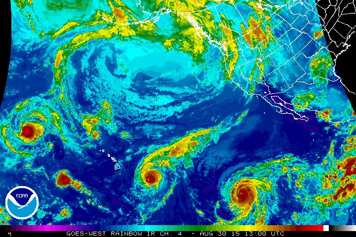
The Atlantic tropical season is usually weak during El Nino years, like this one. Meanwhile, the Pacific is quite active, per climatology. As of Sunday morning there were 3 major hurricanes, with Ignacio approaching the Hawaiian Islands. He will likely stay north of the Islands through early this week. Nonetheless, there is a chance for Hawaii to get hit by a tropical storm this season as it will remain active.
Speaking of the Pacific, it should become more apparent to you that El Niño isn't the major driver in our local pattern. We have been drying out in the past two months. The PDO and PNA play far more significant roles in conjunction with El Niño. Right now, the big players are keeping the significant storm track away from the state.
Internally, we are sharing some ideas on analogous years to this one. We are reviewing the latest climate models and comparing that to our historical patterns. We will be getting more in depth as per the fall and winter outlook as we sort through the details. As of now, this El Niño year is not really like any other. The weather may be boring here now, but we are always occupied on when that will change for the wetter.