Current El Niño Remains 2nd Strongest, but Differs From Previous Events

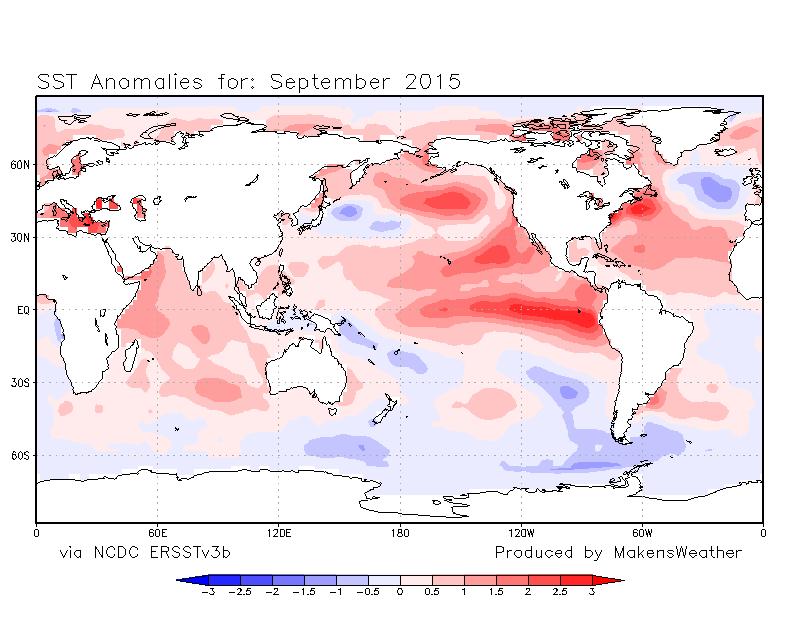
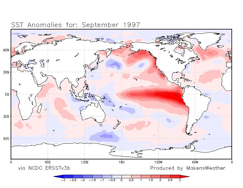
As of September, El Niño remained as the second strongest recorded since 1950. The strongest September El Niño occurred in 1997.
In the grand scheme of things, 65 years of data is not all that long, so comparing our current El Niños to previous ones is not necessarily a good idea for the basis of a forecast.
However, let's compare the El Niño events simply to show just how different each one of them can be.
Here are the winter precipitation measurements from previous El Niño events. You can see how different the pattern of wet and dry areas has been.
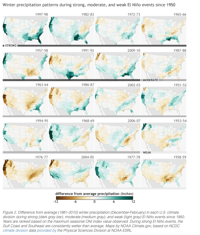
Note that not all of the "strong" El Niños were wet for California. For example, 1965-66 was quite dry across the west coast. For moderate El Niños precipitation patterns are even more of a toss-up.
This is due to the fact that there are so many other factors to consider, more than just El Niño. El Niño is the warming of the Southern Pacific Ocean stretching westward off the coast of South America. However, we must account for the temperatures of all other ocean areas globally when sorting through a given weather pattern.
Yes, September 2015 has a warm Southern Pacific Ocean just as in 1997. Yet, look at the globe and you'll be able to pick out different ocean temperatures between the years. This leads to a unique weather pattern that is only associated with 2015.
This year, as El Niño has strengthened, Colorado's temperatures have become historically warm and we've seen drought return. September was the warmest recorded in 121 years for the state. October, so far, is on track as the warmest also. As far as moisture, September was the 21st driest and October could end historically dry also, but the good news is we have moisture coming this week. For further perspective, Denver has only had 19% of its average fall precipitation to date. This was hardly the case in a very wet September and October of 1997, with a very similar El Niño set up.
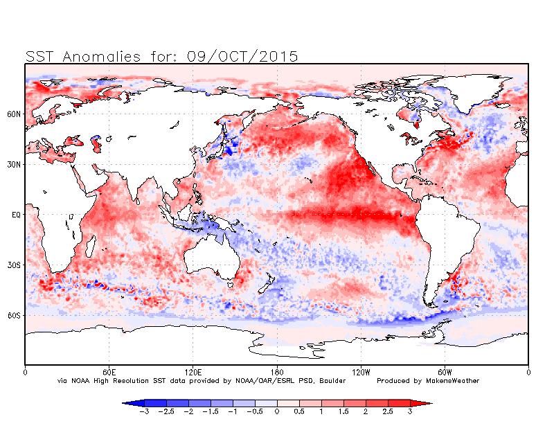
This goes back to the fact that Colorado's weather is dependent on far more than El Niño. This year, the Pacific Ocean off the Western U.S. has been incredibly warm. By staying unusually warm, the ocean is creating a "road block" to any storm pattern that has attempted to develop.
The last week there is a small area of the Pacific between Hawaii and Alaska that has cooled. This has allowed a large area of weather to develop and cover the southwestern U.S. and is part of the reason we'll see wetter/cooler weather for Colorado this week.
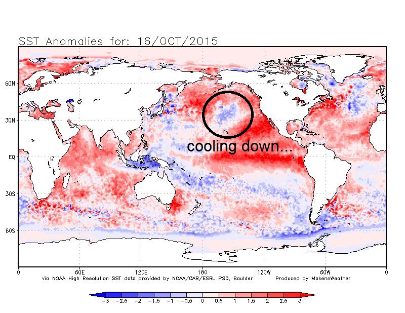
This isn't expected to be a lasting change. Forecast modeling and recent trends indicate that the same pocket of cooler ocean is warming again. This will mean a drier stretch of days will return for at least some length of time.
For the sake of time I have not included the global impact of so many other ocean areas, but I feel the example shown here is plenty enough to draw a conclusion that a.) although this El Niño is like that of 1997 the weather pattern is not the same, and b.) every El Niño will be different, meaning we can hedge some bets toward seasonal predictions, but ultimately Colorado's weather will remain a learning experience.
Each year adds more data, and with that there is more statistical significance to the El Niño, or La Niña, events. We simply haven't witnessed enough of them yet to know how each will act.