The State of the Atmosphere: Sunday, November 22, 2015

It's been a month of feast or famine for snow lovers across the region with snowfall totals through the first 22 days of the month ranging from just a trace to nearly two feet along the Front Range.
As of this morning, Denver International Airport has recorded 8.3" of snow so far this season (all coming this month), while our station in Denver has recorded just 4.8" of snow. On average, Denver ends November with 12.7" season to date snowfall, so we have some work to do to catch up, especially in the city proper.
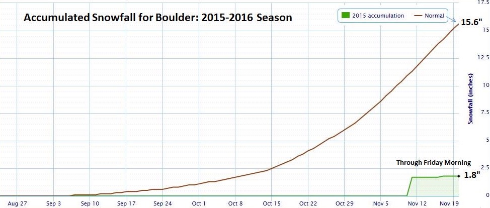
Boulder is also off to an incredibly slow start. On Friday, the National Weather Service shared out this great chart showing Boulder's snowfall deficit. Even with the light snowfall event Friday night the city remains well below normal to date.
For Denver's southern suburbs and the Palmer Ridge the story has been much different, with totals of upwards of 15" common for these areas. Here's a look at the latest CoCoRaHS snowfall reports for the month for a variety of locations in the region:
| Station | Total Snow |
|---|---|
| Fort Collins (2.9mi NW) | 2" |
| Boulder (2.2mi W) | 3.1" |
| Denver (wx5280) (1mi S) | 4.8" |
| Greeley (3.8mi W) | 5.1" |
| Boulder (4.7mi E) | 6.1" |
| DIA | 8.3" |
| Broomfield (2.3mi SSW) | 8.5" |
| Centennial (3.7mi W) | 12.1" |
| Littleton (6mi W) | 14.8" |
| Black Forest (3.9mi NNE) | 16.5" |
| Castle Rock (3.9mi NW) | 22.5" |
| Evergreen (1.1mi S) | 23.6" |
The week ahead
The coldest temperatures of the season are forecast to arrive in Colorado just in time for Thanksgiving. We'll have a chance for snow also on Turkey Day, but the big story may be the cold.
Until then, temperatures will be nice, with afternoon highs in the 50s each of the next three days. By Wednesday, changes start to arrive, with snow returning to the high country and clouds and cooler temperatures making themselves present across the Plains. If you have travel plans across eastern Colorado on Wednesday things at this point appear okay, it'll likely be a bit more of a slow-go if you're heading northwest out of town.
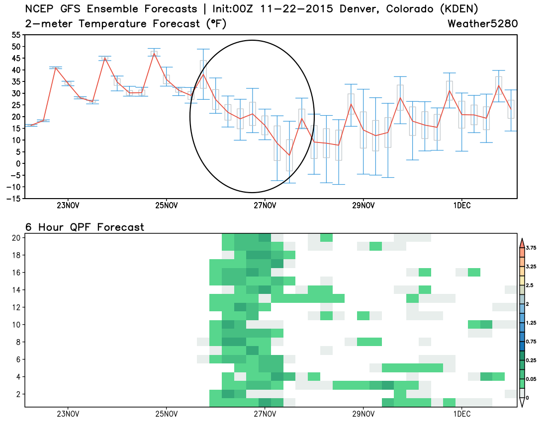
The system arriving Wednesday evening will tap into some cold arctic air, with highs both Thursday and Friday in the 20s (or teens?), and overnight lows likely in the single digits for Denver. There's pretty good agreement between all the models today with the cold. Here's a look at last night's 00z GFS ensemble run, with good agreement between all the members that the cold is coming... (the temperature slide Wednesday into Thursday circled).
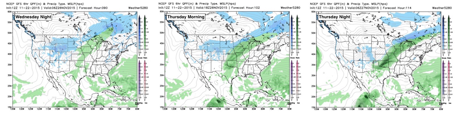
And here's a look at the GFS ensemble forecast map showing the cold air spilling down the east side of the rockies by mid to late week:

For snow... This is obviously a high-impact forecast given the current timing of this system. The way things currently stand, it looks like the chance for snow arrives with the front very early Thursday morning, with off and on light snow continuing Thursday night up and down the I-25 corridor. General consensus is that snowfall totals will be greatest along and west of the interstate, with lighter totals across the Plains.
While on paper it may not look like a huge snowfall event for the metro areas, several inches will be possible during the day Thursday if things align just right. While not overwhelmed with the amount of low level moisture to work with, models have been in pretty good agreement that we'll see some light accumulation by Thursday evening. Couple that with very cold temperatures, and road conditions could become tough on Thanksgiving Day, especially into the evening hours.
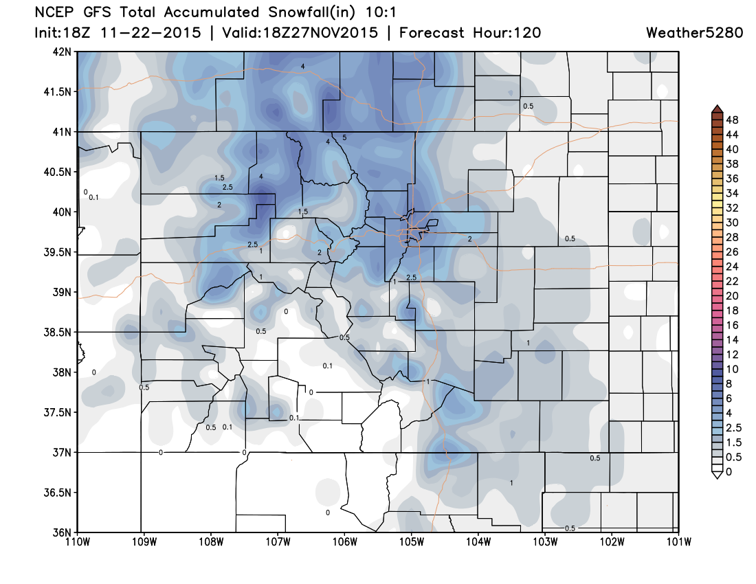
As for totals, we'll hold off for now in issuing an official snowfall forecast and see how things progress over the next day or so. As it stands, this look a "somewhere in the 2 - 6 inch range" type of system, with the EURO ensemble mean ~2" for DIA, and GFS/CMC suggesting closer to five or six inches for the Denver area. While these systems typically under produce rather than over produce... that's only true until it's not, and with some high snowfall ratios and just enough moisture, some areas could see some decent totals. Under this setup, the jet stream is going to be running right over the top of the cold air dome. Instead of a widespread and organized area of snow, this sets up narrow bands of snow that can sometimes lead to quick accumulation over a small or narrow area. Meanwhile just down the road, little is happening.
Here's a quick look at the 18z GFS snowfall forecast... which I actually like the look of. Perhaps a bit on the heavy side for Denver, but not outside the realm of possibility either.
Before we get too confident in seeing accumulating snow Thursday we'd like to make sure the system continues to progress as expected (doesn't stall), and keeps on track (doesn't hang north). Either of these solutions would obviously lead to a much better Thanksgiving Day than currently forecast, so stay tuned.
Bottom line: if you're trying to decide between traveling Wednesday or Thursday we'd suggest Wednesday. Accumulating snowfall not a done deal for Thursday, but the potential is there, and with that travel may be icy. Please stay tuned to the latest forecast as we head into the week.
With this week being a big travel week we'll stay all over this approaching storm system and offer any updates needed here in the next several days, as well as zero in on a snowfall forecast for northeast Colorado. Definitely subscribe to Weather5280, we don't want you to run the risk being left out in the cold (and snow!) missing Thanksgiving dinner. Gobble, gobble.