No Two El Niños Are Alike; Cooling Waters and Precipitation Trends

Ah El Niño, the winter is closing in on you my so-often misrepresented phenomena. All those media headlines promising that you'll do this, that, and the other, and for what?
Yes, that's right, you never promised one thing or another, other than to be a warm area of ocean in the central and southern Pacific and that you will attempt to shift seasonal areas of heavy versus light precipitation. That you have.
No two El Niños are alike
For the current winter, December and January (February's data will be included by early March), you have provided this type of precipitation coverage over the U.S.:
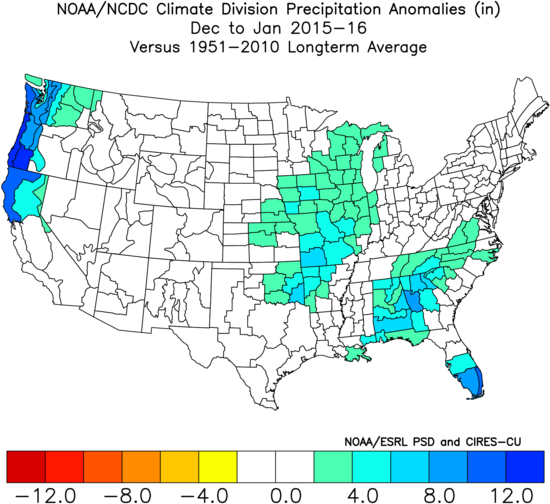
The good news here is that we haven't, yet, noted extreme dryness in any of the climate divisions. That's a good thing. A La Niña pattern will support much drier conditions.
In your other years since 1950, El Niño has given us this type of winter precipitation coverage:
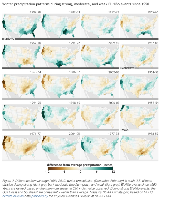
Do you all see many similarities between this year and the other El Niño years? The Pacific Coast, mostly northern, has had some nice moisture as well as the Great Plains and the Southeast this season. Yet, no other El Niño year perfectly matches. And, just look at all the El Niño winters and try to pin down an exact duplicate of years. Can you? Not really as, again, no El Niño acts like the others in terms of who, where, when, and how much moisture will be received. There are even several El Niño Winters that were incredibly DRY across the Pacific Coast. Colorado, "average" so far, our winter doesn't typically benefit from a lot of moisture in an El Niño phase – you'll remember that from my blog about just that last fall.
Aside from the precipitation patterns across the U.S., which I showed you because that very topic has been so terribly misleading in most El Niño media coverage, this El Niño has been like others in terms of the ocean itself.
Remember, El Niño is a warmer than average region of Pacific Ocean. That's it; that is all that El Niño is. So let's compare El Niño to what should be compared to... it's own cycle.
Warm Ocean Is Only Part of the Equation
We've noted many strong El Niños in the past such as '82-'83 and '97-'98. This one remains the third strongest, since 1950, based on the MEI (Multivariate ENSO Index - Index of ocean/atmosphere conditions).
November sea surface temperatures alone, not including how the atmosphere behaved as is in the MEI, this current El Niño had the warmest water on record – which explains the El Niño headlines saying this is the strongest one ever.
I prefer the MEI over the ocean temperatures alone because the MEI accounts for how the atmosphere reacts to the warm ocean. For Colorado and the U.S., the atmospheric change is what impacts us.
Using that MEI, this El Niño is similar to those of '57-'58, '65-'66, '72-'73, '82-'83, '91-'92 and '97-'98. Again the similarity is to the ocean temperatures and the atmosphere's response between these years. Note, the precipitation pattern over the U.S. in those most similar years:
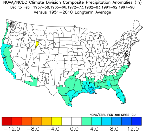
Doesn't quite match the map above for our current season, does it? Not quite, as again, no El Niño will be alike in terms of the who, what, when, where, and hows of the precipitation pattern.
Expanding drought conditions looking more probable
With that said, El Niño does favor around average to above average precipitation this year. That alone is a major takeaway considering the prolonged drought we've seen in areas of the U.S., and drought is likely to increase as El Niño weakens once more.
That statement leads me to this: our current El Niño is weakening, and we have a chance of La Niña returning before the end of the year. Meaning, drought frequency is looking more probable from the summer into fall.
I've plotted here the surface ocean temperatures, red is warmer than average, from January 14th and February 14th. Look for the cooling (less red) trend taking place in the highlighted area, though overall it remains quite warm:
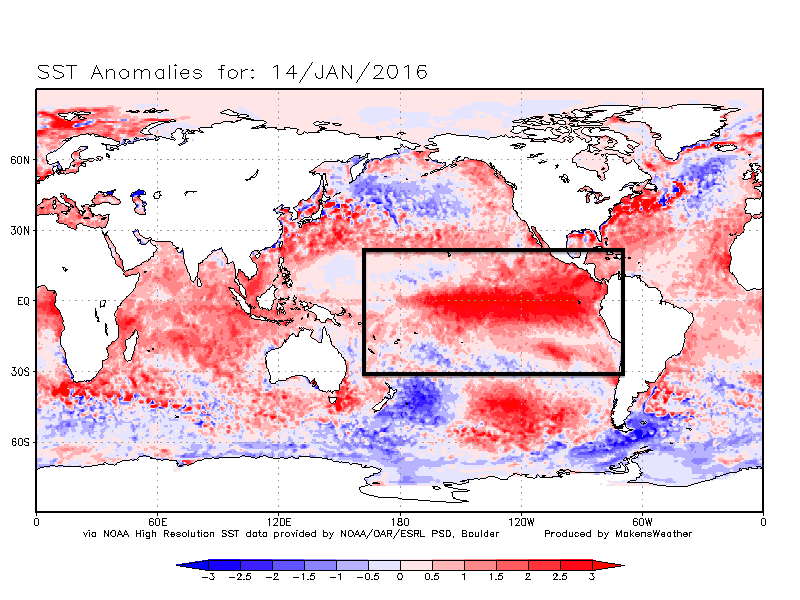
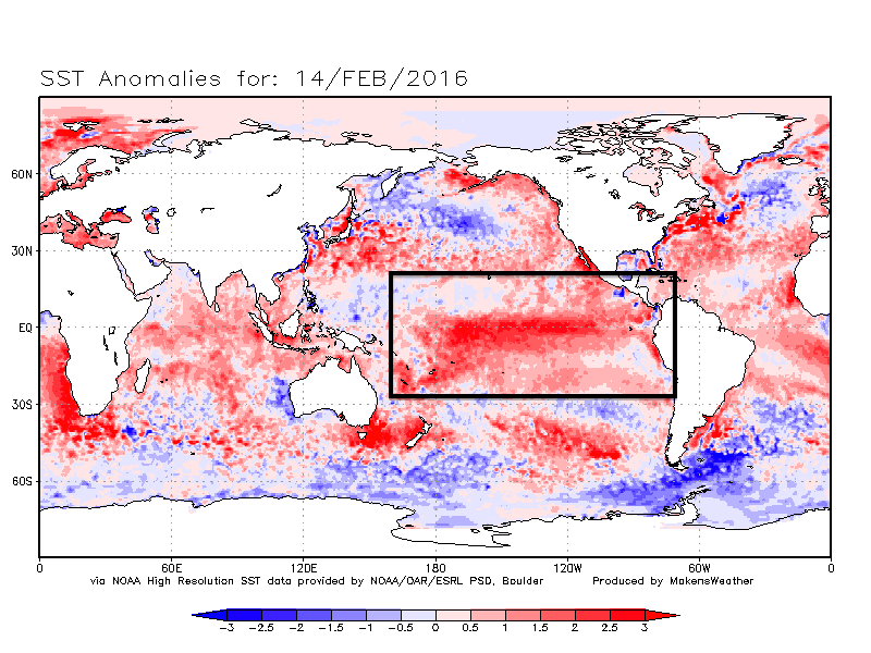
This cooling indicates that El Niño is weakening, and that makes sense based on those similar years. They weakened at about this time, too.
Of these years, the cooling process went at different speeds, but the trend here is that most of those years returned to a neutral or La Nina phase by the end of the respective year. Two years remained in a weak El Niño phase, two in a neutral phase, and two hit a La Nina phase. Based on this climatology we stand a 4-in-6 chance of getting rid of El Niño in just a few months.
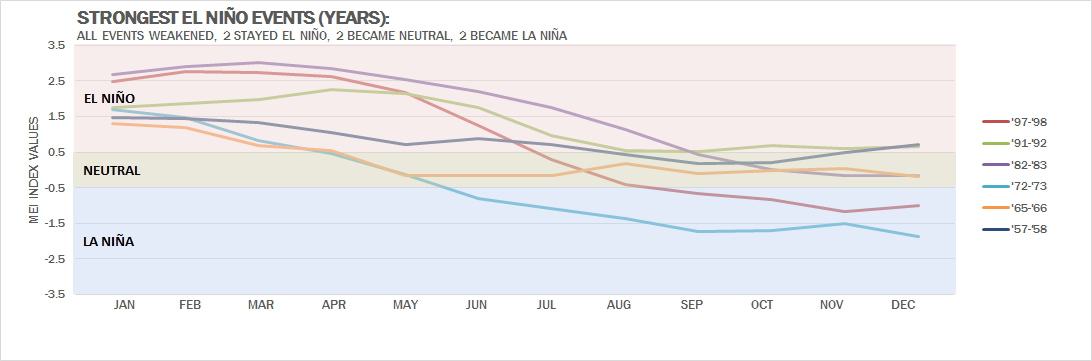
Let's take that further; the climate forecast models don't disagree. The group of models project a 9-in-10 chance of neutral to La Nina conditions by the end of the summer. For those interested, here's the ENSO Forecast.
This should resonate with those of you who frequent Weather5280. We've been calling for this for awhile now. Recall posts done by Brian Bledsoe. Also, look for future posts on the climatology Colorado phases as we begin to transition out of El Niño. Until then, all eyes on March and April, as we still expect a return of a more active storm track as we head into Spring.