
Jet-enhanced banded snowfall: What is it, and how did it contribute to the October 25th snowstorm in Colorado?

One of our main mechanisms for snow producing storms along the Front Range is what we call upslope: winds that push up against the Rockies and create the lift needed to produce precipitation, which in the winter usually falls in the form of snow. For the northern urban corridor that's typically a northeasterly or easterly wind, but that differs depending on where along the Front Range you are located.
With a classic cutoff low snowstorms, that upslope is deep – meaning we have strong upslope winds well up into the atmosphere and all the way down to the surface which help deliver ample moisture to the Front Range and often widespread, heavy snow along the urban corridor.
There are other ways to achieve heavy snowfall along the Front Range, however. When we are lacking deep upslope we depend on other methods of achieve areas of greater lift and instability and ultimately heavier snowfall. One of those ways is with a roaring jet stream overhead, and what we often refer on here as "jet-enhanced" or "jet-induced" banded snowfall. These types of setups may produce generally light snowfall across most of the area, with only narrow bands of heavier snowfall with sometimes little movement over many hours.
What is jet-enhanced snow?
In the jet stream, a "river" of high velocity air located between 250 and 300mb (or about 30,000 to 40,000 feet above sea level), there are pockets of locally faster wind speeds called jet streaks. These jet streaks can be greatly impactful on our weather here at the surface, both during severe weather season and during the winter season as well.
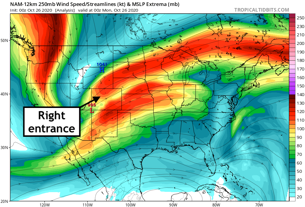
In a jet streak, there are areas of rising and sinking air, or areas of diverging and converging air. Where air diverges (such as the right entrance of a streak), the result is upward motion – often helping to promote severe weather during the warm season, or localized heavy convective snow during the winter season.
We often see these setups along a northwesterly flow aloft, but sometimes with a westerly or southwesterly flow as well, like we did this weekend. Sometimes, with a southwesterly jet and a low-level cold front like we saw Saturday night we see overrunning, which produces little more than light snow across Eastern Colorado, or even freezing drizzle (which we also saw this weekend!). Sometimes, however, enough ingredients come together to produce big-time snow totals as well.
The ingredients that came in to play for the October 25, 2020 snowstorm across Colorado included a mix of many factors, including:
- A potent arctic cold front and weak upslope flow at the surface.
- Warm air overriding, particularly across southern Colorado where the subtropical jet helped pull in ample moisture into Southern Colorado.
- Multiple jet streaks leading to focused areas of heavy, banded snowfall.
The role of the jet stream in the October 25, 2020 snowstorm
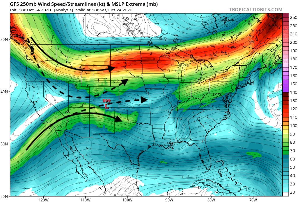
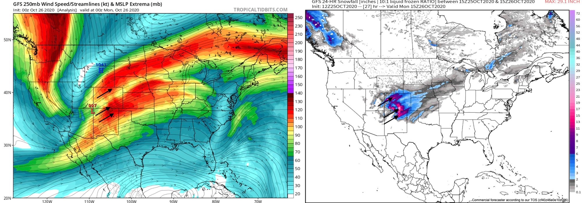
The map below shows winds at 250mb, or about 34,000 feet above the surface valid this last Saturday morning, October 24th, 2020 – about 24 hours before snow moved into Colorado. The stronger winds (yellows/reds) to the north of Colorado is what we commonly refer to as the polar jet stream, while the stronger winds you see to our south is the subtropical jet.
The dashed arrows indicate the change that was forecast in both the polar and subtropical jet between Saturday morning and Sunday evening. The polar jet was forecast to buckle significantly bringing a southwesterly flow above Northern Colorado, and the subtropical jet would strengthen and move over Southern Colorado. Under these dashed lines (roughly speaking) is where we expected the heaviest snow to fall along the Front Range:
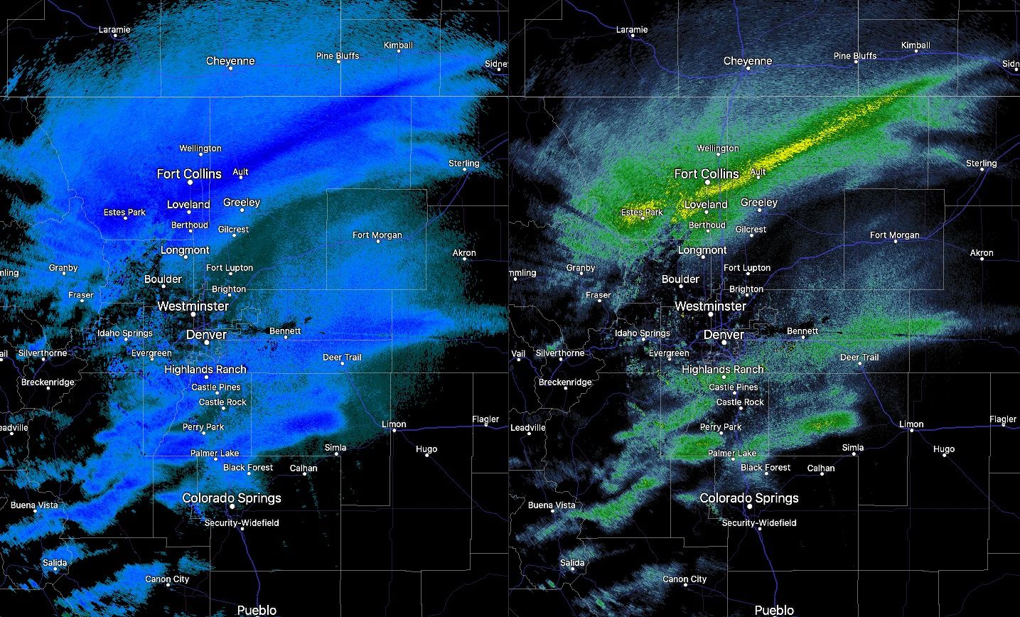
So, fast forward 24 hours, and here was the setup Sunday evening. A large buckle in the main flow bringing banded snowfall to Northern Colorado, and strong subtropical jet helping to deliver moisture and heavy snowfall to southern Colorado.
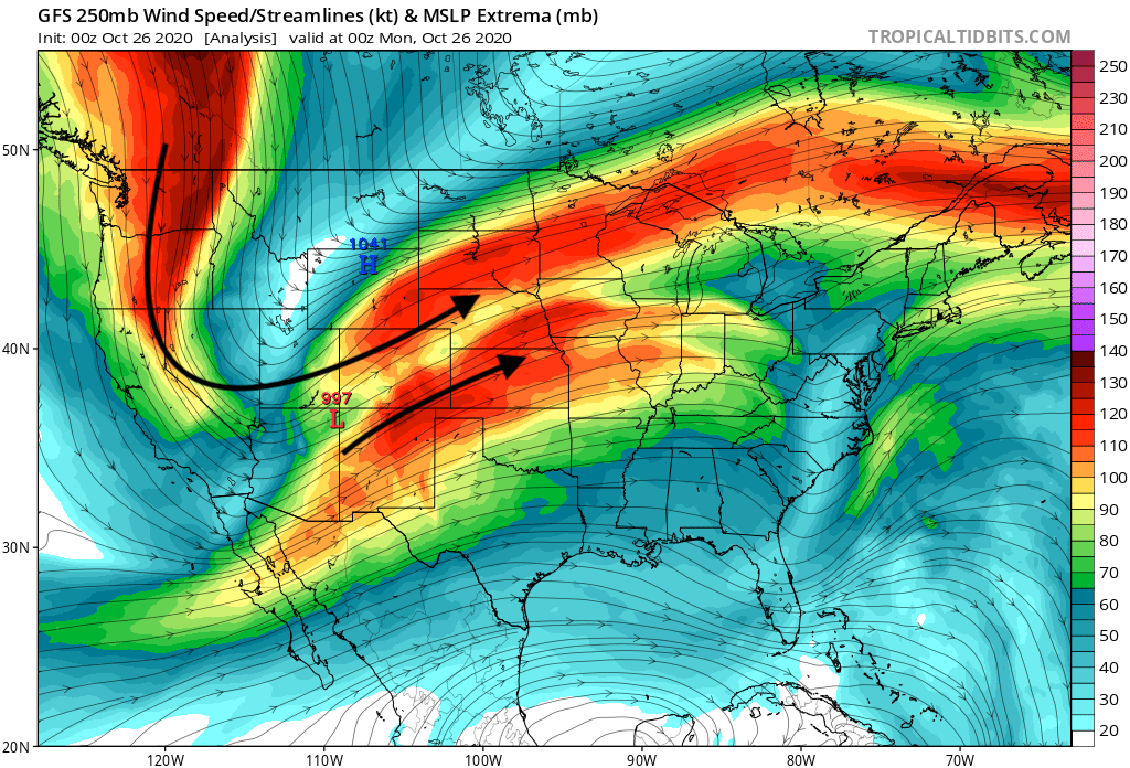
Notice what's going on in between, because this is important. Many of you asked why Northern Colorado and Southern Colorado were getting hammered, but between Denver and Colorado Springs snowfall (in general) was much lighter. In the image above it's easy to see the jet max to Denver's north and Colorado Springs' south, with lighter winds over the two cities. Simply put, there was much less energy overhead to help promote the heavier banded snowfall that we saw to our north and south.
Finally, it's also fair to say that the influence of the southern jet may have acted to slow the southern progression of the northern jet yesterday. Often enough with these setups it's more focused on the polar jet only, without perhaps the presence of the subtropical jet. In those cases we see the band of snow march reliably from north to south over the state, and not give the appearance of the Denver-Colorado Springs region being "skipped" over.
A look at the forecast
Take a look at the two sets of images below. They look similar, but there are small difference that made a big impact on the eventual forecast and outcome of this storm.
The first image is the GFS forecast from last Friday for Sunday evening. The GFS at this time was forecasting the heavier snow band to set up over the Denver area, (really only about 40 miles south of where it ended up), with less snow overall as well than what ultimately panned out.
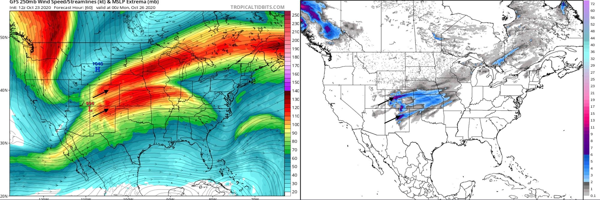
If we compare it to what happened, we can pick out a few subtle differences. The northern jet max ended up just a few miles further north than the GFS was forecasting on Friday, and it was also slightly more buckled, forcing a bit more of a northerly component to the flow than we see in the image above. You'll also note winds are a bit weaker between the northerly jet max and southerly max, and the southerly jet was also ultimately much stronger than the GFS was forecasting as of Friday morning. The stronger southern jet helped deliver a good deal of moisture and heavy snow to portions of South-Central Colorado with this system!
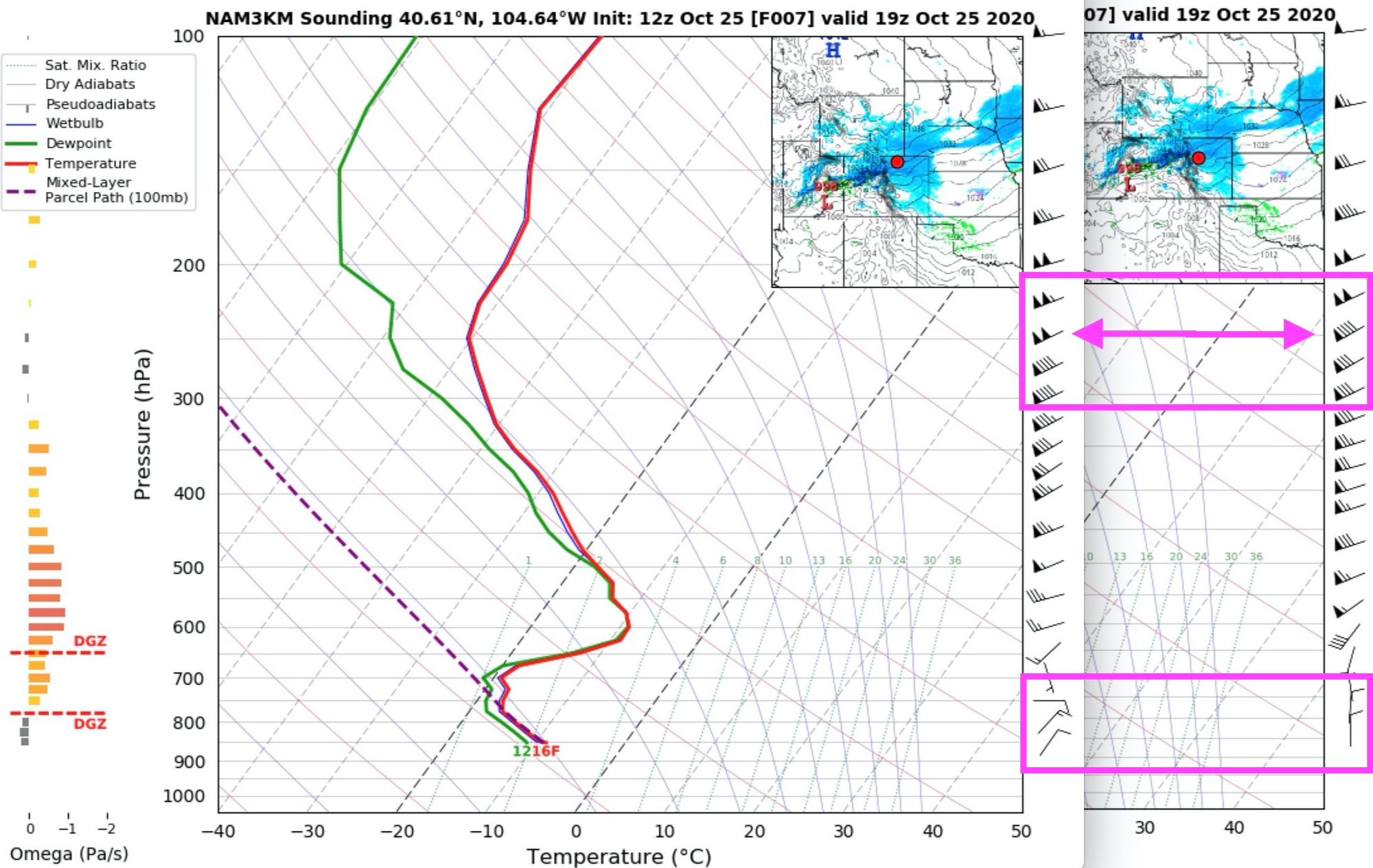
If we take a look at conditions around 1pm on Sunday, when the heaviest snow was falling over Fort Collins, we can see just how subtle the difference between the jet maximum (aided by surface winds) can be between where we see the heavier snow vs not.
First, here's a look at radar just after 1pm, the darker blues (or yellow) indicate heavier precipitation. It was snowing in Denver at this time, but not amounting to all that much. Notice that the band is stretching from southwest to northeast, just like the orientation of the jet pictured above!
Looking at forecast soundings for the same time, we see slightly stronger winds at 250mb up north as compared to over the Denver area – about 100 knots vs 90 knots. You'll also note that closer to the surface (the bottom pink square) winds were out of the east and northeast up near Fort Collins at that time (upslope!) where in Denver they were due north. (You can find a handy cheat sheet for reading wind barbs here). It was likely a combination of these two factors – slightly stronger winds aloft and better upslope – that produced the greater totals up north vs over the Denver area, combined with that jet streak just not moving much during the course of the day.
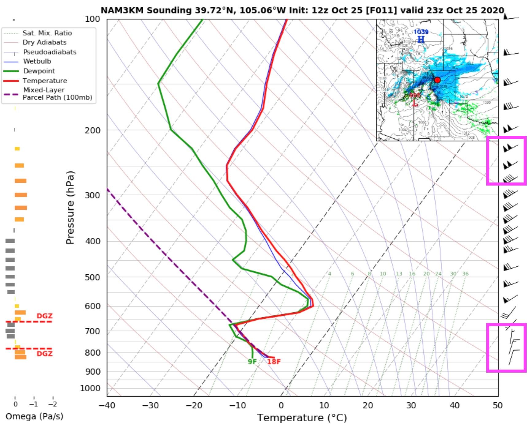
By the time we had a similar sounding in Denver, the jet max was moving a bit quicker south and east. So, if we look at the sounding around 5pm we see stronger winds aloft and slightly better upslope flow near the surface (winds shifted a bit more northeasterly vs due north), and this lined up with when we saw the band of heavier move overhead. Unfortunately for snow-lovers these conditions were just far more fleeting than when the band had stalled up north for much of the day.
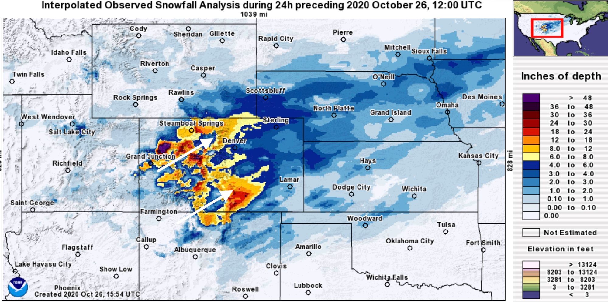
With the above considerations, it's easy to look at snowfall totals over the 24 hours ending the morning of October 26th and see where and why we saw the heaviest snowfall totals from this storm:
It also helps explain why it's so hard to pinpoint where the heaviest bands will occur with these setups. Had that jet maximum set up just a few miles further south on Saturday, it would have been a completely different storm for the Denver metro area. We saw, as the band moved overhead Sunday evening, the type of snowfall rates these banded snowfall events are capable of producing.