The State of the Atmosphere: Sunday, February 21st, 2021

Yesterday's snowfall forecast worked out quite well, in what was another exciting snowfall event for some folks across the region – though over a notably smaller area than the storm prior.
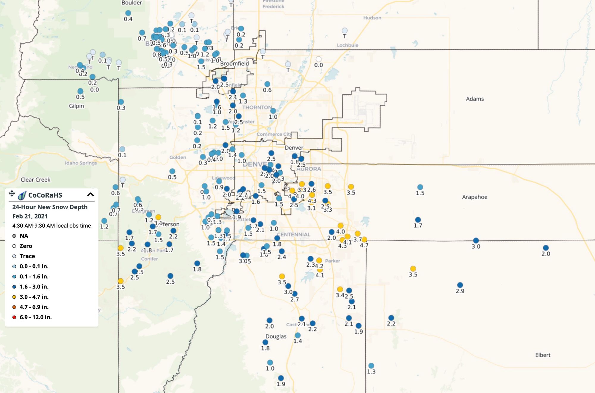
We placed a swath of 2 - 4" across the south and southeast side of town and this ended up working out quite well. The snow came down in a hurry, and for areas that saw more than a short burst of that snow, it accumulated quickly – on everything. Here's a look at CoCoRaHS reports this morning, with quite a few 3 and 4" snowfall reports from areas southwest of Denver, and of course across the southeast metro area as well.
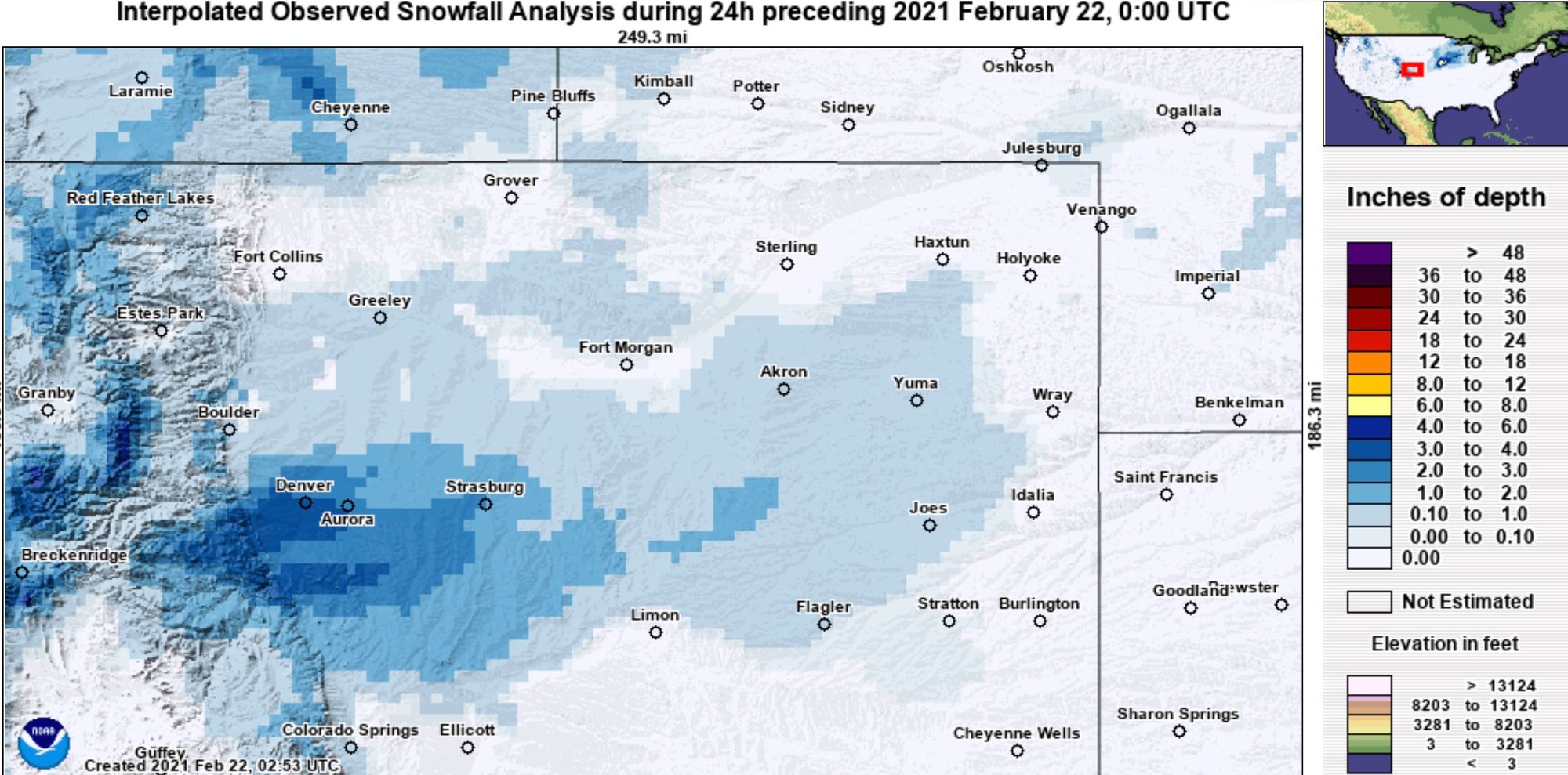
The interpolated totals map shows how small an area it was that picked up the greatest snowfall Saturday evening, as well as a pretty good match to our forecast issued in placement and coverage.
The week ahead
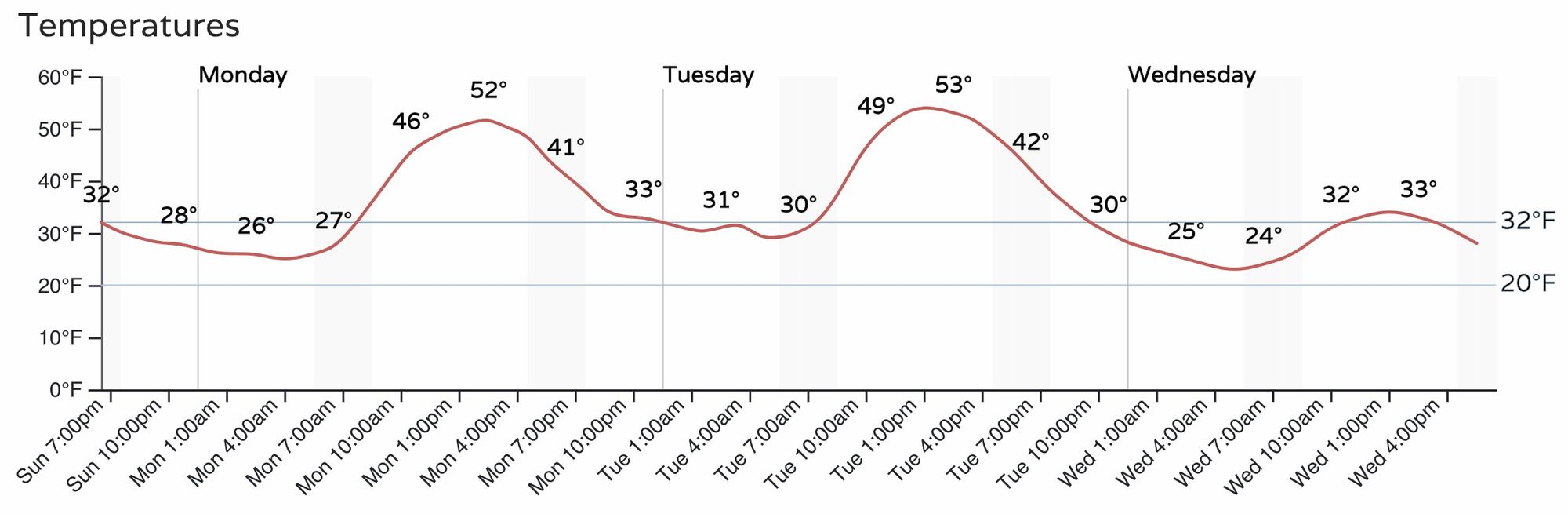
The wind has picked up, and with the temperatures will warm to start the work week. No advisories issued at this time, but you can count of gusty winds overnight along the foothills, and likely windy conditions at times through Tuesday.
Temperatures will warm nicely Monday and Tuesday before a cold front arrives late in the day Tuesday and drops us back near freezing for Wednesday. Here's the hourly temperature outlook for Denver to start your week:
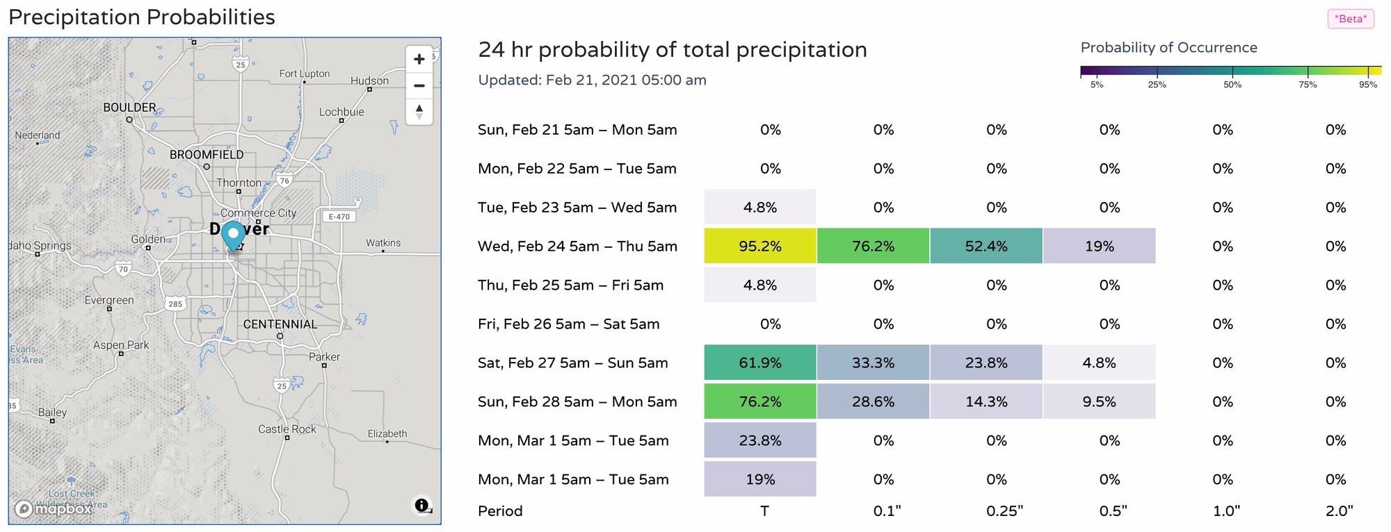
It's Wednesday into Thursday that we'll be watching for our next chance of snow along the Front Range. Insiders will recall we were discussing this system already last week. It continues to look like many of us will see snow by the middle/latter half of the week, with greatest probabilities for accumulating snowfall looking to again be along and west of I-25 from how things look today.
As you can see in the hourly, right now it looks like the chance of snow will be greatest Wednesday night, with increasing probabilities for precipitation through the afternoon on Wednesday:
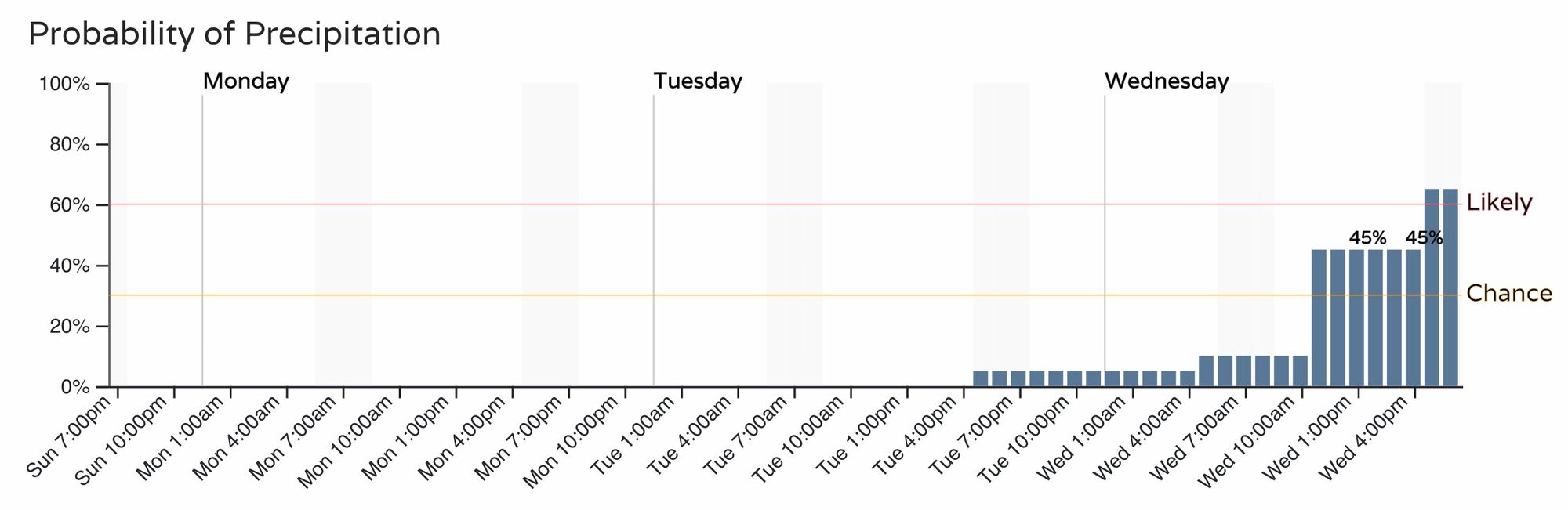
For Denver, actually decent odds for some moisture with the midweek storm, and you'll note another spike in probabilities for precipitation by the weekend as well. For now we'll focus on Wednesday/Thursday as there's more than enough uncertainty with it, and little agreement with how things will look by the weekend.

For Colorado Springs slightly better probabilities for midweek, which aligns with our discussion last week where the concern is for the best activity to drop south.
Models are overall pretty bullish on snowfall potential, at least for the foothills and immediate plains. The further east from the hills you are, the less potential we see in capitalizing on the heavier snow this week.
This system will drop quickly out of the northern rockies Tuesday night, and into the Four Corners region Wednesday night into Thursday morning. This will coincide with the greatest upslope along the Front Range as well, likely between late afternoon Wednesday and the very early morning hours on Thursday.
It'll be interesting to see how things progress as we start the week. Like we said last week, the tendency has been to dig the energy pretty south, which would hurt snowfall chances along the northern urban corridor. Today's runs are generally a good spot for many of us to see snow – but the GFS did lose the system nearly completely for a few days, and the Euro has differed at times with its storm track (though overall it has been much more consistent in recent days).
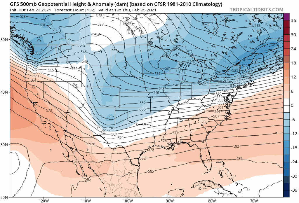
Looking at the GFS 500mb map for this coming Thursday morning over the last 8 runs shows the trend nicely (watch the blues over Colorado). From a non-event to digging it much further south and west. The question is, does it continue that trend too much and hurt our odds for snow?
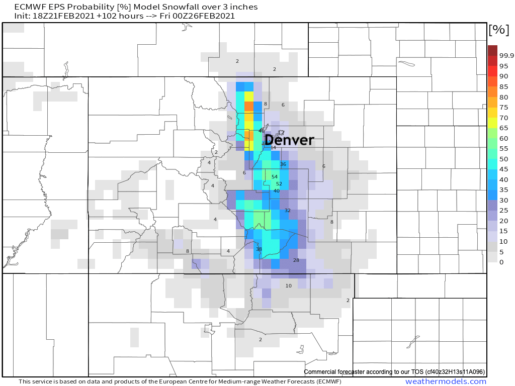
The current probabilities for 3" of snow or more look about right from the European ensemble model. Pretty good odds for the Front Range foothills and western Palmer Divide, and given the southern bias a bit better chance for the Springs vs Denver proper at this time:
Still a LOT of time to track this one, with definitely some upside potential if you live along and west of I-25. We'll be enjoying the quiet weather (if brief) to start the week, and will be tracking the changes on the way for Wednesday for you as we do.