What exactly was the weather that caused the Colorado floods
Historic, and in some spots unprecedented, amounts of rain fell across portions of Colorado over the last week, causing widespread, damaging flooding, and tragically taking lives in its wake. This once in a 100 (or even 1000) year event has, from a meteorological perspective, been extraordinary. As sunny skies return to Colorado this week, and communities across the state begin the slow rebuilding process, we wanted to take a closer look at the cause of these rains, and share some historic perspective.
The Setup
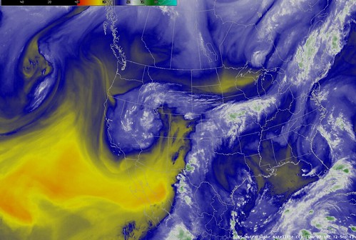
It is fair to say that there were multiple players which came together in concert to produce the flooding we have seen over the past week. Here are some of the factors: A stalled out frontal boundary provided the energy, or lift, needed to create the rain showers. Then there was the strong late season monsoon which acted like a conveyor belt to bring deep moisture from Mexico into the Four Corners region; this supplied the humidity to turn our showers into the intense rainfall. The collision of the monsoon pushing north, and the frontal boundary pushing south, caused everything to stall overhead for several days, the result being the tremendous flooding the region has seen.
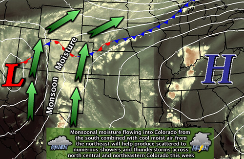
With a blocking ridge of high pressure to our east, and thus the very slow progression of the upper low to our west, all the right ingredients came into play to bring the Front Range an historic late season rain.
Had that cold front been stronger, it would likely have moved farther south before stalling. The opposite is true if the cold front had been weaker – the stall probably would have been farther north. As it happened, the strength was near perfect ( or imperfect rather ), for heavy downpours along the urban corridor.
Related: Colorado flooding as seen from space
Our terrain contributed too; Boulder County probably received more rainfall than any other county, over 20" in some spots, due in part to the upslope nature of the storms that got stuck there. Upslope adds lift, or energy, to the storms by forcing the humid air up a mountain side resulting in very heavy rainfall (just like our upslope snows). In the case of Boulder County, the Flat Irons and mountains were the perfect upslope addition. The combination of an overly-energized, late-season monsoon, a stalled frontal boundary, and upslope "trapped the heaviest rain into a corner" that it could not get out of.
The persistence of this system, (it was still raining in Boulder late into the night Sunday) was something maybe above all else unusual for Colorado. We get our share of heavy rains, flooding, and monsoonal moisture, but to have all the ingredients in place for seven days straight is truly a rare event.
Historic Context
For a bit more perspective on just how much rain fell during the last week, we can take a look at climatological norms, and other historic rain events. Several places along the Front Range received a years worth of precipitation during the event, with the majority falling during a 48 hour period last Wednesday and Thursday.
Take Boulder for example, where one CoCoRaHS spotter recorded 21.13" during the seven day stretch. In a given year, Boulder will average just 20.0" inches of precipitation ( combining snowmelt and rain). With still 3.5 months to go, Boulder has set an all time annual precipitation record for the year with 30.14" recorded to date.
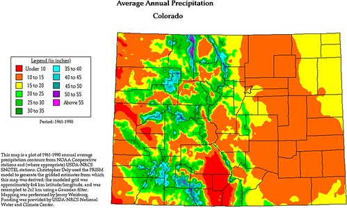
A similar situation was seen in other parts of the metro area. Aurora recorded 11.23" of rain Wednesday into Thursday, just a few inches shy of their annual average of 15 inches.
The Big Thompson Flood of 1976 has long been the metric for destructive flooding in Colorado. This past week has likely changed that. Rivers feeding the South Platte surged to all time highs. The Big Thompson stream gauge Thursday night hit 10.55 feet, breaking the old record of 9.31 feet set during the 1976 flood. Tonight, the flood waters creep ever closer to the extreme northeast corners of the state, prompting Nebraska officials to warn folks to move away from the river.
Devastation
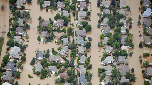
Preliminary numbers are hard to fathom. According to the Denver Post, tonight the death toll climbed to 8 as rescue efforts continue for the fifth straight day. Colorado emergency managers, estimate 17,495 homes have been damaged, with nearly 1,500 of those being completely destroyed. Hundreds of miles of roadways remain closed for the time being, which has only added to the difficulty in rescue operations.
The total number of people unaccounted for continues to rise and fall as it is a very difficult thing to track. Estimates in the last day have reached upwards of 600 people still unheard from, the cause of which could range from miscommunication, to phones being inaccessible, and of course worse.
While these are only preliminary numbers, and fluctuations both up and down should be expected over the coming weeks and months, it goes to show just how destructive of a week Colorado has faced.
In Closing
The flood water is receding now, thankfully, but with trillions of gallons trying to fit down one river it will take a long time to get it out of here; perhaps weeks before all rivers are back to their normal.
It has been a trying week across the state, a profound thank you to all the first responders working tirelessly, and often at risks to themselves, to get everyone safe, and an abundance of local and state officials working around the clock to keep everyone informed of all the latest pertinent information.
Hang tough, Colorado. Oh, and enjoy the sunshine!