The State of the Atmosphere for Sunday, November 17, 2013

Warm and dry start to November for Denver
It has been a dry first half of November for the Front Range. Through November 15th, Denver only recorded 0.03" of precipitation at Denver International Airport (DIA), where official records are kept. The average temperature through the first 15 days was 2.8 degrees above normal at 44.4 degrees. As we head into the second half of the month, there are some indications this pattern could start to change.
We have talked a lot this fall about the persistent ENSO-neutral conditions, meaning no La Nina or El Nino to help direct weather patterns across the United States. In other words, the equatorial sea surface temperatures in the Pacific are near average. ENSO-neutral years can mean a variety of outcomes for Denver's seasonal snowfall totals. Last year, which was also neutral, had a very slow start to the season, and it still ended above average for snowfall in Denver with 78.4" recorded at DIA. The previous neutral winter, however, in 2008/2009 ended with just 38.1" on the season.
Interpreting pattern controls
What this variation means is that there are multiple factors that come into play to drive weather patterns across Colorado and the United States, and ENSO is only one. Others we pay close attention to, especially during neutral years, are the North Atlantic Oscillation (NAO), the Arctic Oscillation (AO), and the Pacific North American pattern (PNA).
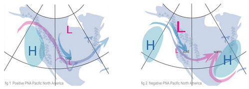
Generally speaking, 'negatives' from any of these patterns can mean a more active storm track for Colorado, while 'positives' often drive the quiet patterns like we have experienced so far this month. The PNA being negative (right) is often a sign of an active pattern for Colorado, as the blocking high to our west retrogrades further west off the coast allowing for strong troughs to dive south out of the Pacific northwest, while a positive PNA will often push the storm track east of the state.
Similar effects are seen from shifts in the AO and NAO, both of which have been very positive over the last three to four weeks. Combinations of all three can mean a variety of different things as we see.
Pattern shift looms?
What we have been watching over the last couple of days is a shift in the NAO and AO back toward neutral, with many of the ensembles going negative by the end of the coming week. The PNA (which actually has been negative) heads in the opposite direction, but still stays negative through the period. Here are the 14 day forecasts for each:
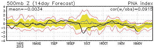
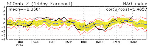
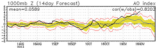
What is interesting here, is that all the global models have picked up on this idea too and try to bring much colder weather to the state by the end of the week, possibly even a chance for snow. While there are still plenty of run-to-run fluctuations (we are talking 5 days out still), the general pattern for the end of this week and even the following week at least for now appears to be headed toward a colder and more unsettled pattern.
Until then, expect a return to mild temperatures to start the week. Highs through Wednesday will be at or near 60, with mostly sunny skies. Changes start creeping our way by Thursday, so expect updates throughout the week as things continue to evolve.