Snow on Track for Tonight, Early Thursday

Though we hit 63 degrees Tuesday afternoon in Denver, significant weather changes are in store for us today. A sharp cold front will push through the region this afternoon, with light snow developing by mid-to-late evening.
Temperatures are in the low-to-mid 20s this morning across much of the area. Some partial sunshine will probably allow temperatures to rise to the lower 40s by around noon before our cold front pushes through in the early afternoon. Temperatures will fall for the remainder of the day behind the cold front, with readings below freezing likely by 5pm.
In the wake of the frontal passage, weak to moderate upslope flow will develop via easterly surface winds. Add a bit of moisture to the mix, and we're looking at light snow developing by mid-to-late evening. Our best guess is that snow will develop over the immediate Denver metro area from north to south between approximately 8pm and midnight.
Light to moderate snow can be expected during the early morning hours on Thursday as temperatures drop to their lowest levels since early January -- likely dropping to a very cold 10 degrees by the time you wake up on Thursday.
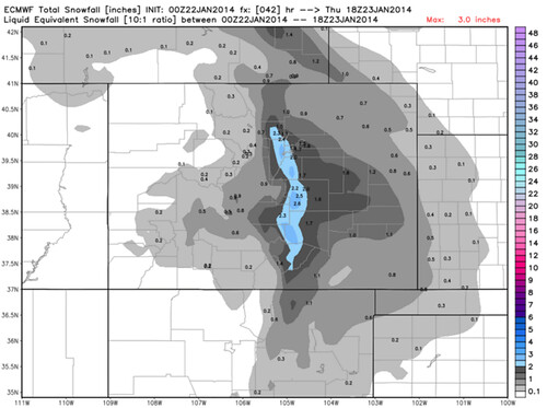
The main factor that will limit snowfall accumulation with this system is the relatively short duration of the event. At less than 12 hours, snow should begin to taper off by dawn Thursday and should be over for most folks by mid-morning.
We generally expect a fairly widespread 1 to 3 inches of fluffy snow to have fallen by the time all is said and done. A look at snowfall probability amounts from the most recent SREF run (at press time) shows an 85% chance of >1"; a 70% chance of >2"; and a relatively low 30% chance of >4". It should be noted, however, that this is one of the more bullish models. That said, if you average all of the available modeling, you end up with about 2" in most spots.
After snow pushes out of the area Thursday morning, expect at least partial sunshine by afternoon. However, even with some sunshine, temperatures will probably struggle to make it above the mid-20s for a high -- nearly 40 degrees colder than Tuesday's high of 63. Temperatures rebound nicely for Friday with highs near 50, and it will be even milder on Saturday, with highs back to near 60!