Steamboat Weather Summit 2014 Part II

David Green: Social Media and Collaborative Forecasting for a Weather Ready Nation
Yesterday I posted the first post in a series on last week's Steamboat Weather Summit. I discussed David Gochis' work at UCAR/NCAR on short-term high resolution weather modeling in efforts to better prepare for such events as the Colorado flooding we saw in September. Today we turn to David Green's lecture on social media and collaborative forecasting.
Where do we go to discover breaking news or weather? A few years ago the television and radio were our go-to sources for such information, but today, most of us would answer "I saw it on Facebook, Twitter, or received a push alert to my mobile device."
This is the challenge that faces the National Weather Service (NWS). They're working to change the way they've done business for decades in an attempt to build a communication channel that will engage the millions of people on social media. Leading the charge for the NWS is David Green, who knows that the task ahead of him won't be easy.
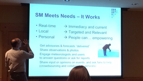
David firmly believes that the mission of saving lives and protecting property should be the priority of the NWS. Recently, media outlets have begun to rely on issuing live Twitter and Facebook updates, providing live chat rooms, and pushing alerts to cell phones -- all with a fair amount of success. But what's the next step? It's becoming clear that the NWS needs to collaborate with other weather sources, including the media, to create a consistent overall message to the public. Denver is a terrible social media location for mixed messages. As an example of how mixed a message can get on social media, just wait for that next storm and tally up the differing weather predictions you'll find on Twitter.
Mixed messages in the face of a dangerous weather system can lead to loss of life. Did you know that more people die of adverse road conditions than anything else weather related? Those drivers could have made different choices if they had access to a clear message, regardless of the source they choose. A clearer message in the future, brought about by improved collaboration between the NWS and other media sources, will be key in keeping the public safe.
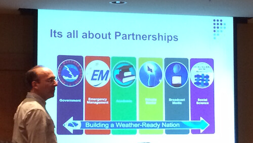
NOAA and the NWS continue to improve their messaging, gradually refining the process of collaboration between different offices and organizations in the weather community through their Weather Ready Nation (WRN) program.
The goals of the Weather Ready Nation initiative are to come up with clearer and more concise messaging around events. Examples of this would be to replace a typical NWS Tweet of "Heavy snow with accumulations of 8 to 12 inches tonight" with something more specific like "I-80 will likely be impassable after midnight due to heavy snowfall." The specificity of the message is more engaging, more actionable, and more likely to be re-tweeted. The idea is to communicate quickly and efficiently the forecast weather risks to the public, and in doing so to fully utilize the power of social media.
While NOAA's Weather Ready Nation continues to evolve, it is important for the public to participate in the process by giving feedback and getting engaged. You can read more about the WRN roadmap and see how to get involved on their website.
What's your method for getting weather information? How many social networks do you turn to in the event of adverse weather, and how consistent do you find the messaging from one organization to the next?
Tomorrow I'll share with you Greg Carbin's lecture on reviewing 2014's Severe Weather Forecast Product Enhancements. Greg is the Warning Coordination Meteorologist from the Storm Prediction Center.