Thursday PM Snow Update
All in all, the going forecast is still on track for this evening. Models continue to struggle with where the heaviest snow band will set up, which means they are producing a wide range of totals across northeast Colorado through Friday night.
Rain and snow showers are slowly starting to develop across the foothills and east of Denver across the plains. We can expect these showers to become more widespread with any rain changing quickly to snow as we head into the evening hours.
We wanted to share with you the latest snowfall plots from the GFS, Euro and NAM models. All of which bring measurable snowfall to all of northeast Colorado through Friday, but vary greatly in how much and where. This is less a forecast as to "how much" but rather to show differences in where these models are taking the greatest QPF over the next 24 hours. The Euro (center) is the most bullish of the bunch, with the widest area of heavy snow. The NAM (right) is least favorable for high snowfall totals in Denver proper (as is often the case) and would lead to more of a 3 - 4 inch event, rather than the six+ inches shown by both the GFS and Euro. For reference, Denver is highlighted in white.
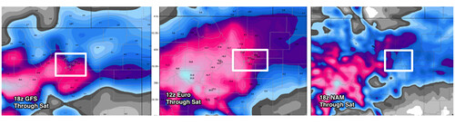
Luckily, or unluckily, there are many other models to consult as well. The latest RAP (high resolution) model has come in with nearly one inch of liquid through tomorrow night which helps discount the NAM, if only a little. The SREF is also on the low end of totals, but still tries to bring more or less four inches to the metro area. The Canadian and Japanese models both look quite healthy for snow across northeast Colorado and have trended the heaviest precipitation a bit further south today -- toward Denver.
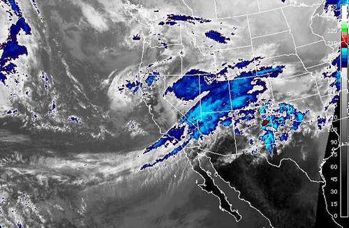
Looking at the GOES west IR, it's clear there is plenty of moisture to work with, the difficulty remains exactly where that will end up.
No adjustments to the snow totals and Bust Index above, but may end up making some adjustments as we head into the evening hours, so stay tuned. First order of business might be to expand zone 3 further east.
We will continue to monitor as we head into the evening and bring updates as necessary. Expect travel across a good portion of Colorado to become treacherous as we head into the overnight hours with likely a messy commute on hand for Friday morning.
Will this be a boom or will this be a bust?! We're getting ever closer to finding out...