The State of the Atmosphere: Sunday, March 9, 2014

It's been an active start to the month of March for Colorado. Two wet storms have pushed Denver's snow totals for the season to just over 30 inches (still 16 inches shy of where they'll need to be by March 31 to end the month at average), but modest gains nonetheless. Both systems brought beneficial moisture to the region, though not all in the form of accumulating snow. Through the first week of March, Denver International Airport recorded 0.61 inches of precipitation, well above the normal value of 0.14 inches to start the month. Snowfall month-to-date is now at 3.5 inches. On average Denver sees about 11.5 inches of snow during the month of March.
We will be in between systems Sunday and Monday. This means a great deal of sunshine and warm temperatures along the Front Range. Pretty remarkably, the GFS MOS guidance has highs in the upper 70s Monday, guidance we haven't seen in some time. We think we'll be cooler than this in Denver, especially if mountain wave clouds kick in ahead of our next system due in Monday night. An increase in clouds Monday afternoon will keep our temps cooler than currently forecast -- but likely mild nonetheless.
Another dramatic shift in the weather comes overnight Monday into Tuesday as our next system moves into the region. Highs Tuesday will be some 30 degrees colder than Monday with a chance for rain and snow returning to northeast Colorado.
This system does look colder than the last two and therefore we do expect mostly snow from this event. That being said, timing has the bulk of the precipitation falling during daylight hours Tuesday, and that in combination with modest QPF, we (at-this-time!) are expecting little accumulation at lower elevations. At this point the biggest wildcard we see as potential for heavier snowfall will, like our previous two systems, but enhanced snowfall Tuesday afternoon due to convection -- not yet being picked up too much by any of the models.
Tuesday's system is still offshore in the Pacific, which should always be pause for ruling anything out until it comes inland and we get a better sense for timing and track. As it stands, however, both the GFS and EURO have similar ideas on how it progress across the west, before ejecting east and rapidly intensifying.
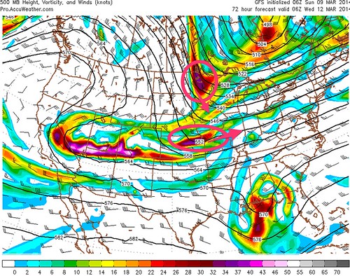
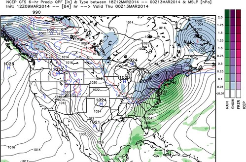
Notice on the GFS how it leaves behind a lot of energy as it passes over Colorado Tuesday. The surface low, while not all that strong at this point, then gets way out in front of the forward leading energy, and the impact across northeast Colorado (while cold) is minimal snow-wise.
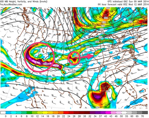
East of Colorado the southern piece of energy joins forces with the northern branch, enhancing it and strengthening as it moves east.
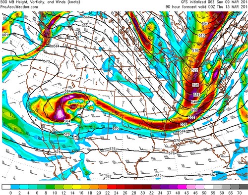
Then take a look at what the GFS has in mind for Wednesday into Thursday across the northeast. A 984mb low cranking east/southeast of New York with driving snow across New England clear through to West Virginia. The EURO looks very similar, though the track is even a bit further south than the GFS. The incredible winter for the east continues.
For the west, upper begins to take hold as this system moves east Wednesday. For now we are expecting a period of quieter weather across the west, with only a few little blips on the radar post Wednesday, but no significant storms at this time.