Tracking Our Next System Due in Wednesday

Warm and breezy ahead of Wednesday PM cold front
Our next weather maker will start producing snow in the high country as early as Wednesday morning before bringing cooler temperatures and a chance for rain and snow to the Front Range Wednesday evening into Thursday.
Ahead of the front will be mild, though reaching 70 degrees in Denver could be a stretch tomorrow depending on how fast the clouds start to build. The wind will really pick up across southeast Colorado for Wednesday as well. That, in combination with low humidities and warm temperatures, has prompted the National Weather Service to issue a Red Flag Warning for that area.
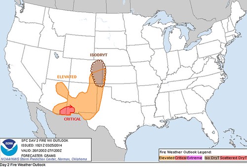
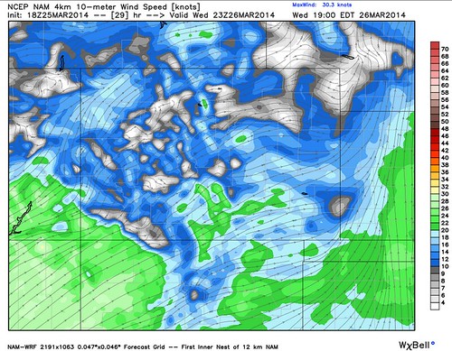
Below (left) is a capture from the SPC indicating areas at elevated fire risk Wednesday, as well as the potential for isolated dry thunderstorms across eastern Colorado. On the right are forecast 10m winds (NAM), with greatest wind threat across southern Colorado.
There is not a tremendous amount of cold air with this system, so we do expect (especially initially) some rain/mixing with any precipitation that does fall. In fact, we may see a few thunderstorms early on, especially north of I-76, but any development will not be widespread.
Best chance for precipitation will be along and north of I-70 Wednesday and Thursday. Both the GFS and EURO bring between 0.1 and 0.3 inches QPF to the greater metro area with this system, but at this point not much of that is expected in the form of snow. Like our last few systems, don't rule out some spotty accumulation on grassy surfaces, especially as you move west of Denver into the higher elevations.
After this system clears our area Friday we'll start the warm-up once more. Could we break the streak of cold Saturdays this weekend? I think so.