Weekend Storm Track a Mess, Better Consensus Elsewhere

It's been a wild week of 'data watching' with regard to the next big upper level trough due in this weekend. When we last updated, the GFS was extremely bullish, the EURO was faster and more open, and the Canadian was intriguing, but not all that convincing for moisture along the immediate Front Range.
Yesterday's 12z GFS run was 95% drier than the 12z run on Monday. Last night it recovered a bit, tracking the low further south and enhancing upslope for northeast Colorado. This was inline with the EURO as well, which increased confidence in a more southern solution over a northern solution.
This morning things look a bit different again. All three models (EURO/GFS/Canadian) have a different idea of how the upper level low moves across the state this weekend. While there is decent consensus in timing, and all three models show the upper level low closing off, the eventual track continues to be the big question. At the moment, the EURO might be the best compromise between the solutions -- it's deeper and slower than it was Monday and it tracks the low somewhere between the northern GFS track and southern Canadian track.
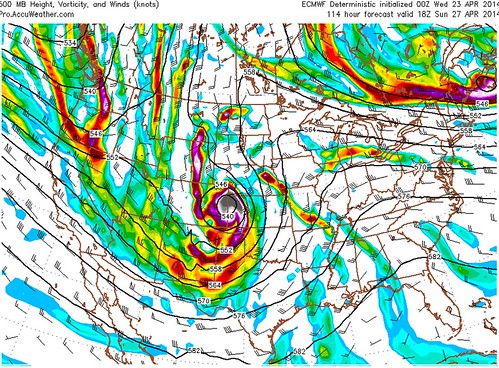
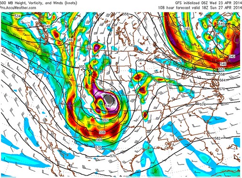
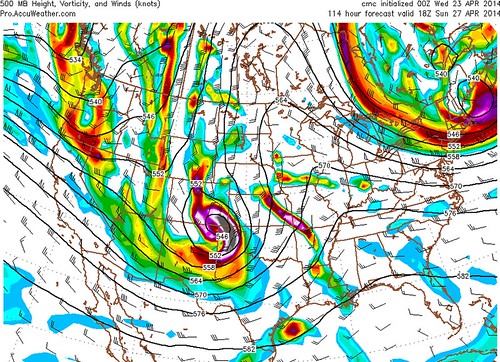
Take a look at 500mb for Sunday afternoon. The 0z ECMWF (left) and the 06z GFS (right) are actually in pretty good agreement with where the upper level low will be -- over northeast Colorado. The Canadian (below) also has a closed low over eastern Colorado, but is tracking that low much further south.
There are still plenty of issues regarding the eventual placement of the surface level low. Like we've seen in the upper level pattern since yesterday, the surface low trend is also south. Should the trend continue, it will likely mean better placement for upslope along the northern Front Range, and less of a concern for downsloping killing our precipitation chances.
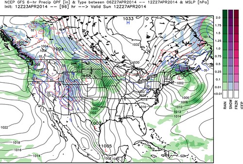
Take a look at where the GFS was tracking the surface low yesterday (left) as compared to today's 06z run (right). Yesterday it trended away from previous solutions and took the surface low well north into Nebraska and South Dakota, the 06z run tracked a 986 low straight across Burlington, Colorado.


Now we look at this morning's 12z GFS run of the same period. It's trended back north, though not nearly as far north as what it was trying to do yesterday. Note, however, that should this track verify, it'll mean much less precipitation for eastern Colorado (notice no green or blue east of the Front Range) as it favors downsloping winds.
The differences here are significant. Should the surface low track too far north, we simply won't see a widespread big precipitation event across eastern Colorado. If the EURO and Canadian have a better handle, and we see the GFS come south once more -- then big time precip is once more in play.
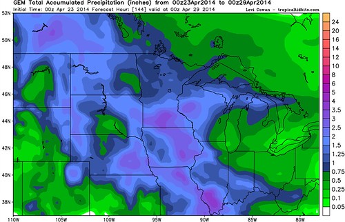
If we were to take a compromise between the northern solutions of the GFS/EURO yesterday, and the southern solution which the Canadian has been pretty consistent on, the middle of-the-road low we see on the EURO might be correct. If so, we'll definitely be watching for flooding concerns, especially along the Front Range foothills. All three models bring spotty QPF of over 1 inch to portions of northeast Colorado through Monday, here's what the rather bullish Canadian has in mind. . .
A lot to watch over the coming days, as it's clear model consensus is not there yet, though it feels like we're getting closer. Things are bound to swing in different directions several times over the next few days, but confidence is pretty good that there will be a large closed low traversing the west this weekend, the question is exactly what track it will end up taking.
More updates to come...