Denver to Thaw, Heavy Mountain Snow this Weekend

Temperatures remain quite cold across northeast Colorado this afternoon, but a warm-up is coming! Temperatures Friday are expected to rise above freezing for the first time since Monday in Denver.
Though no record low temperatures have been broken, Denver spent each of the last two nights in the double digit below zero territory. Denver dropped to -19 degrees F on Wednesday morning, and -16 degrees F Thursday morning.
On Wednesday, Denver set the all time record low high for the date of -1 degree F. The old record low high for the date was 5 degrees set in 1989.
At 4:00pm Thursday, Denver warmed to 0 degrees, ending 45 hours straight with temperatures below zero at Denver International Airport.
While it's been a cold start to the month of February, it certainly hasn't been the coldest. Take a look a this chart shared by the National Weather Service.
It's been a cold start to February in Denver...however other years have been colder. #COwx pic.twitter.com/gcS9lrYpc8
— NWS Boulder (@NWSBoulder) February 6, 2014With downsloping winds Friday, temperatures should start to warm along the urban corridor. Locations with strongest downsloping winds will see warmest temperatures Friday, with still chilly conditions expected elsewhere, especially east. We've kept a chance for snow in the forecast Sunday into Monday for Denver, but at this point it looks conversational at best.
Heavy Mountain Snow
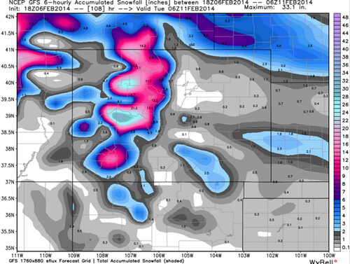
If you didn't make it up last week when many resorts saw upwards of three feet of snow, you have another chance at some great snow conditions this weekend as more heavy snow is set to hit the high country. This is all part of a larger system that is bringing some much needed heavy snow to the west coast.
Both the Euro and GFS have the heaviest snow over the next three days in the central and northern mountains, but I suspect they may be underdone across southwest Colorado. In any case, it looks like 1 to 2 feet of snow will fall across much of the high country, the potential for even more at places like Crested Butte.