Saturday Update: Best Chance of Snow Still Ahead
As we mentioned on our Live Blog this morning, most folks across the Front Range saw <2" of snow overnight Friday, with the exception of a very narrow band of heavy snow from Westminster into Aurora. Snowfall totals under this heavy band ranged from 6 - 10" in Westminster, to 3 - 5" in Aurora. Pretty impressive!
Denver International Airport recorded 0.8" of snow through 7am Saturday.

Many folks on social media and elsewhere Saturday morning were asking questions along the line of: what happened? where's all the snow? As we have been emphasizing since Thursday, the best chance for most of us is still ahead of us later Saturday afternoon and overnight into Sunday. The lull in the snow this morning was fully expected, and we mentioned in yesterday's post that most folks would see less than 2" of snow Friday night into Saturday morning. Now the question is, will it fill back in this afternoon? We think so.
**Here's a rundown of the latest models: **
- 12z GFS: 1.07"
- 12z NAM: 0.87"
- 12z 4k NAM: ~1.0"
- 12z EURO: 0.75"
- 09z SREF: 0.71"
- HRRR: 0.6" (through 1am tonight)
Model Average: ~0.85" (>10" of snow)
The HRRR hi-res model that nailed last night's heavy snow band shows snow increasing from north to south Saturday afternoon. By 6pm Saturday it has most of northeast Colorado seeing snow, with the heaviest up and against the foothills in the Denver area. The HRRR though 1am tonight shows heaviest snowfall totals north and northwest of Denver as well as across the Palmer Divide.
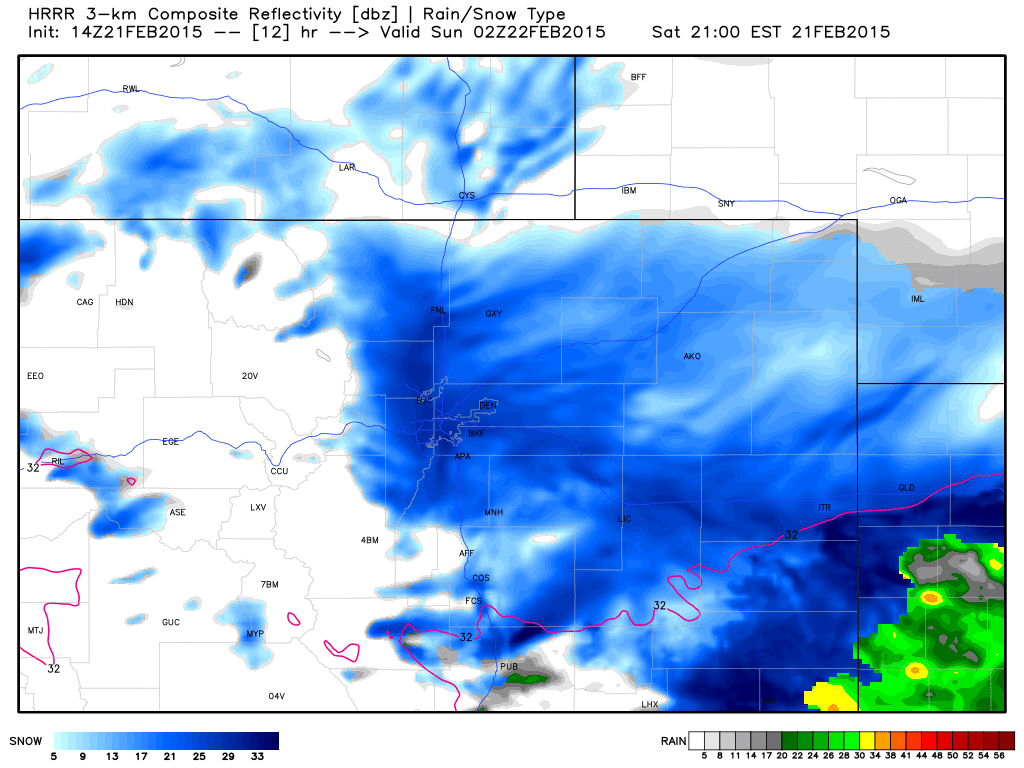
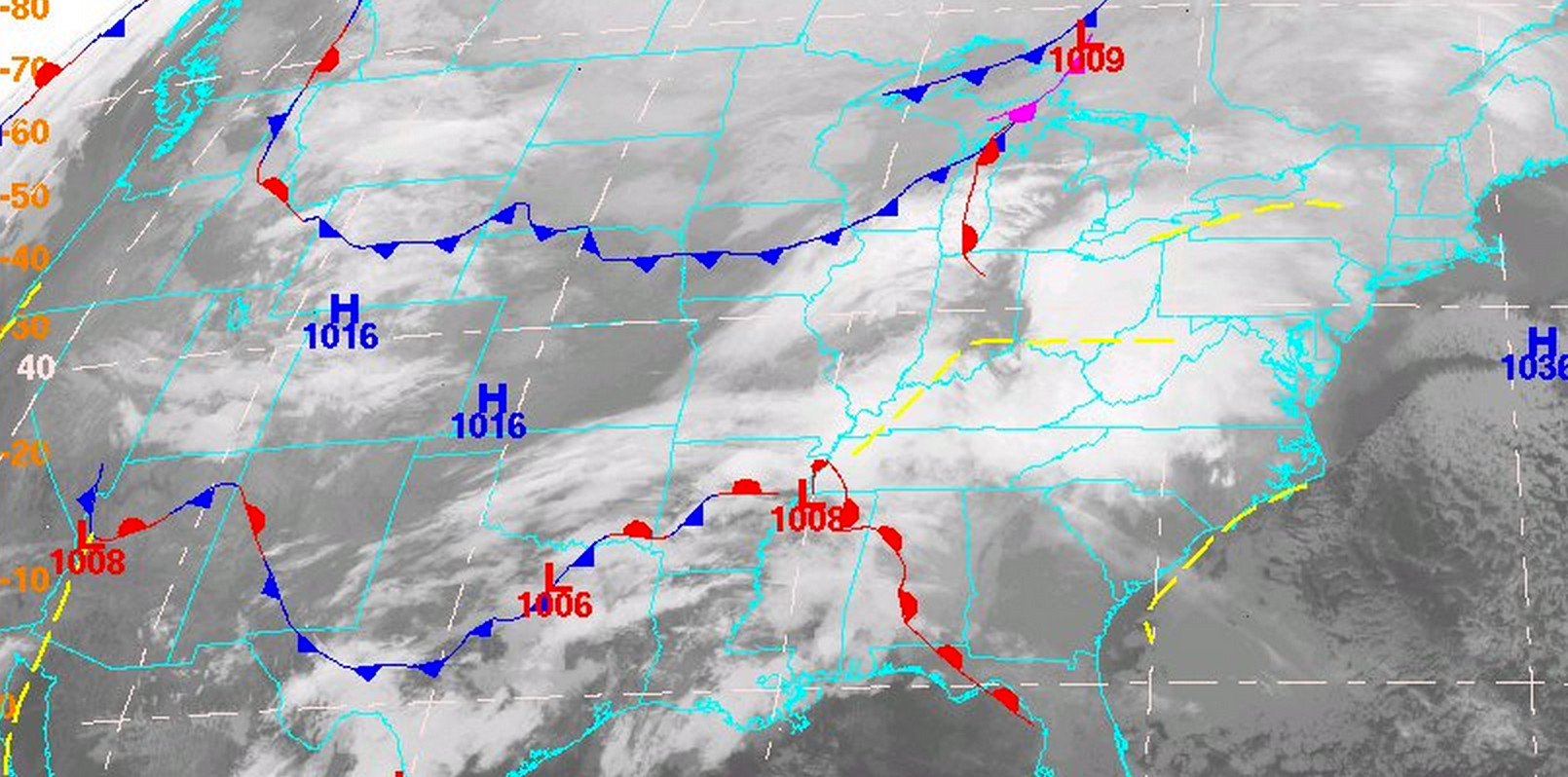
Indeed, the arrival of our next front (pictured below north of Colorado Saturday morning) will help enhance snowfall across the forecast area later in the day Saturday. Snow will be heavy at times -- though with pronounced lulls at times -- over the next 24 to 36 hours. You can track the progress of this front on our current conditions page here.
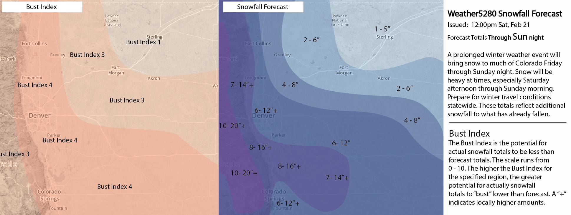
While some 'bust' concern remain, it is appreciably lower than before, and we will leave the forecast we've had up since Thursday as is. We still think 6 - 12" for metro Denver looks like good bet, with locally higher amounts. Those living south and west are in the 7 - 14" zone, with some having the potential to see 8 - 16". We will also be lowering the Bust Index for the I-25 urban corridor from a 7 to a 4. Note these totals are of additional snowfall going forward, so places that saw several inches of snow last night will add to that through Sunday. If the high-end forecast occurs, this means places like Westminster could see >16" of snow with this storm!
Farther south in Colorado Springs, some uncertainty still remains. We still feel good about the 6-12" that is in the forecast, but the GFS is showing a "snow minimum" from Colorado Springs southward. This "hole" is something that shows up frequently when there is a strong northerly wind. The north wind produces a downsloping (snow killing) wind off of the Palmer Divide. This strong north wind would occur with the passage of the Arctic front tonight. This is also the time when other models are painting some of the heaviest snow. While other models do not show this "hole", the GFS has had it for the past several runs. Concerning? A bit... That being said, we should at minimum make it to 6". There is also potential for more than a foot if the heavier bands materialize. Colorado Springs is probably where our greatest uncertainty lies, but the impact of this event should still be rather high.
Here's a reminder of our snowfall forecast, largely unchanged from when we issued it Thursday.
Please keep in mind that regardless of snow totals at your house this is a WIDESPREAD, HIGH-IMPACT EVENT. Roads will become snowpacked and icy as snowfall increases Saturday afternoon and overnight into Sunday. If you must travel, please do so with extreme caution.
We will keep this update short and see how things shake out this afternoon. Of course we'll offer additional updates as needed, and be pushing more frequent updates to our Live Blog through the duration of the storm.
Looking to keep up with all the lateset? Subscribe to Weather5280, and find us on Twitter.