The State of the Atmosphere: Sunday, March 15, 2015

The snowiest month of the year is March, and we are smack dab in the middle of it with hardly any snow. With a warm pattern building in the chances of catching our average snowfall drop with each passing day.
Just 1.9" of snow in the books so far this month at DIA, whereas March's 133-year average for Denver is 11.5". Just one good snowfall could put Denver back to average, or even above. We will likely have to wait for the final days of the month to get that chance; the pattern has been too dry and warm for the month to see any quick change.
March Dry and Cool So Far
The pattern over the lower 48 has been dismal for moisture this month. Here is a look at the March precipitation for the US. The colors indicate the percentage above and below average precipitation.

The month, to date, is cooler than average by a couple of degrees. However, since the 9th Denver's temperatures have been above average and will remain there today and tomorrow. This is not just above average – a record high was set today at DIA and another is possible Monday. Sunday's record was 76 from 2013, but that was beaten when the 3pm observation was 77. Monday's existing record is 75 from 2012.
This Week & Next
This month has been dry, and drawing closer to average with this recent warmth. I don't see much shift coming this week.
The outlook for this week begins warm, with near record highs in the early period. Then, the help of some cooling ocean oscillations will allow a couple of cold fronts to move through.
This will be enough to cool us down, however Denver will likely stay at-to-warmer than average for the entire week. The bulk of the cold air will remain in Canada, so we catch "what's left" of the cold air. Denver's first chance to cool down is Tuesday, but it is not a significant cooldown. A better chance for rain and cooler weather comes Thursday and Friday.
Here are the temperature anomalies for Tuesday. The warmer colors symbolize hotter than average, and the cooler colors for the colder than average. This is a great visual to show the lack of a significant temperature change for the first of the week's cool systems.
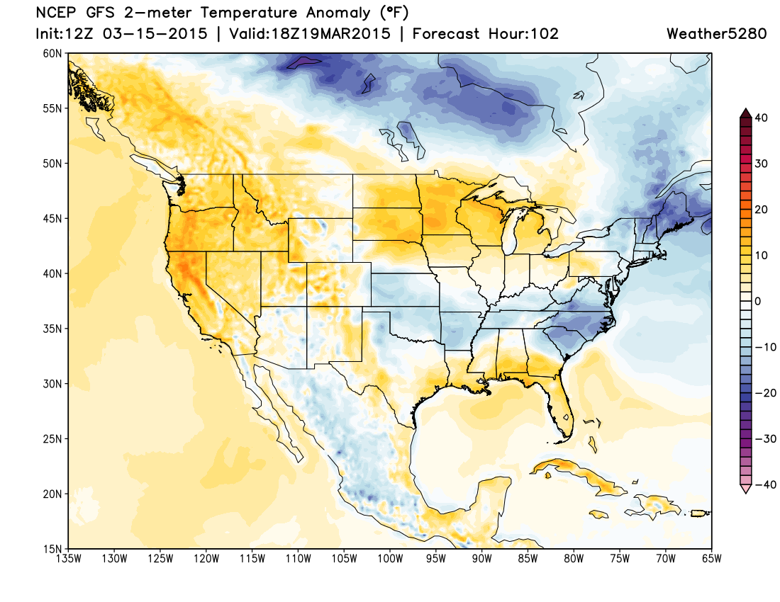
We can disregard the first "cold" system as a game changer. The successive systems expected throughout the next two weeks at this point look to be much the same. Just cold enough to keep us closer to our average. Denver's average high is nearing 55-degrees. The GFS outlook shows a long stretch of near average temperatures. This graph is just like the map above – showing the amount above or below average. Average is the 0 line, and again represents near 55-degrees in this case.
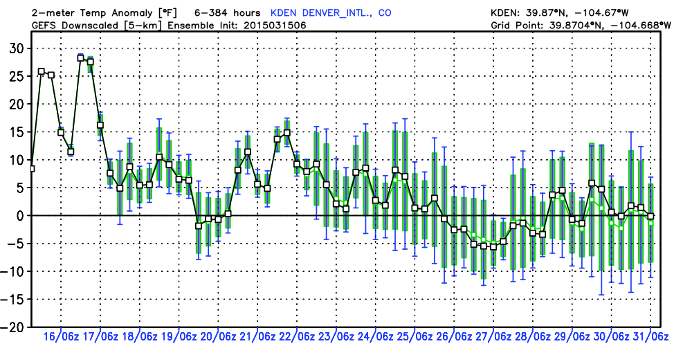
This is valid now through March 31st. It doesn't show any significant cooling for the month. There is a wide range of possibilities though, as the green shaded "range of possibility" bars indicate. At the moment, the best chance for a period of below normal temperatures in Denver looks to come during week two. Even still, the odds of a system cold enough to produce a good snow in Denver is looking slim. The ocean indicators are also weak to show any significant cooling for March.
The precipitation outlook is almost as grim as the temperature outlook to a snow lover. I see two troughs (weather-makers) to move through the rest of this month. One this Thursday/Friday and the other toward the end of the month. The ridge triggering our warming March is just too strong and appears to hold on for the rest of the month. The big global models do bring moisture with each, it's just that they may lack the cold air to produce snow. The best snow chances will be confined to the mountains, Palmer Divide, and Cheyenne Ridge. To the ski industry, the amounts of snow don't overly impress me. Enough to keep you going, but this will be a blue bird month overall.
Thoughts
I am not impressed with the odds of an average snowfall March. I believe temperatures will be at or above average, and snowfall will be below average. We do have rain chances, but here too we may struggle to get to average precipitation for the month.
To keep hope alive for a snow is that the global models indicate a nearing average temperature outlook. And, at least indicate a couple of systems to move through. This is better than a far warmer than average outlook. Even if it is a snow that doesn't stick, I'll take it.
For the rest of the month, I'll be watching the ocean indicators more closely than the global models. If we are to see an unexpected pattern shift it will originate in the teleconnections first...a sharp negative change to the EPO will raise my hopes, and if the PNA can turn negative we could be back in the game. I'll look for that with optimistic hope for the last week of the month, as it isn't going to happen this week.