March Ended Unusually Warm and Dry, Fitting the Long-term Pattern

March was Colorado's 6th warmest and 20th driest since 1895. Further, this year is on pace to be the 4th warmest for Colorado in 120 years. We'll need a good shift in the pattern over the rest of the year to change this.
Last week we saw some good rain and snow for some across northern Colorado, and while our latest system this week brought much needed rain and snow to California it unfortunately missed Colorado by and large. The pattern has been an active one, but we have yet to see that materialize into anything significant locally.
Following a wet/warm winter in our region, a persistence forecast would have called for a wet/warm March. However, that is clearly far from reality in the precipitation field. For one, such a forecast does not fit our current overall dry pattern. For two, periods of drought are consistently warmer than average. We've talked a lot on the site about our opportunities for periods of cooler/wetter weather, but that overall pattern is in a drier/warmer phase. We need to continue to capitalize on the moisture while we can, but as you can see – this can prove hard to do.
Thankfully we did have a wet winter despite the longer term average. Here is the precipitation anomaly for the lower 48 for the winter (December 1, 2014 through February 28, 2015).
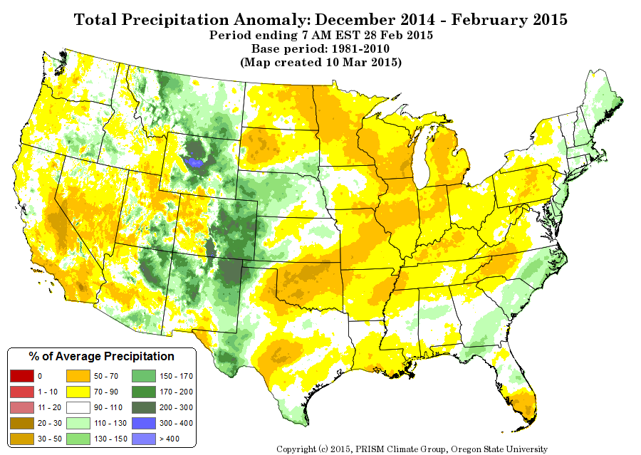
The color shading is based on percentage of average precipitation. For example, eastern Colorado in the green shades represents more than the average amount of rain and snow for the season.
Now, compare that image to this one for March. You can see the radical change – almost a complete reversal!
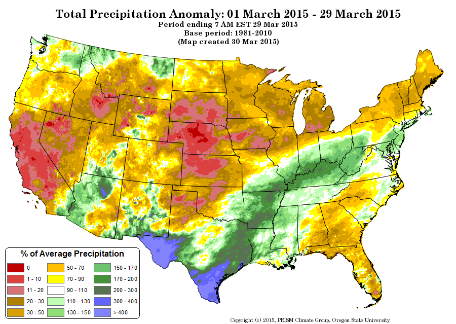
For March, our region became one of the Nation's driest. Just look at the tremendous drought over Nebraska and Kansas, after a wetter than average winter.
So was the winter a fluke, or indicator of a pattern shift ahead? The answer to is far more complex than a simple answer.
I should point out that one wet season, doesn't mean the longer term weather will be the same. Further, the mountains are in a serious drought despite Colorado having a wet winter overall. The winter moisture only benefited central and eastern Colorado.
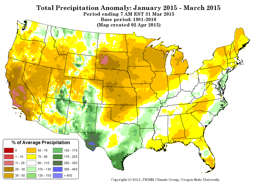
Since January 1st, the 3-month moisture looks like this:
This precipitation "layout" fits with several weather pattern features. I'll explore what I feel are the top three for us right now.
First, the PNA (Pacific North American) index value has remained positive overall from month to month. The PNA is an ocean-atmosphere teleconnection that can influence how a storm moves through our region. A combined variable list produces the "index value".
When that index value is positive, our region's storm pattern is northwesterly and can provide moisture, from the Pacific Northwest, for areas of snow/rain east of the Continental Divide. This was the case for our winter months, but that index value is dropping closer to 0 through March.
The closer to 0 that index value becomes, the storm track becomes more westerly. A western storm track may start with plenty of moisture, but most is lost west of the Divide due to the mountainous terrain and gives Denver dry/windy systems. This explains a drier March, and more representative of our longer term average.
A negative valued PNA would support a southwesterly system for us. These are plenty humid and support our biggest rains/snows. This is what produces our "four corner lows". We didn't have any produce for us this year, and this pattern isn't likely in the short to medium term.
Going beyond the PNA, which is a shorter term indicator, the long term pattern remains a dry one for the region.
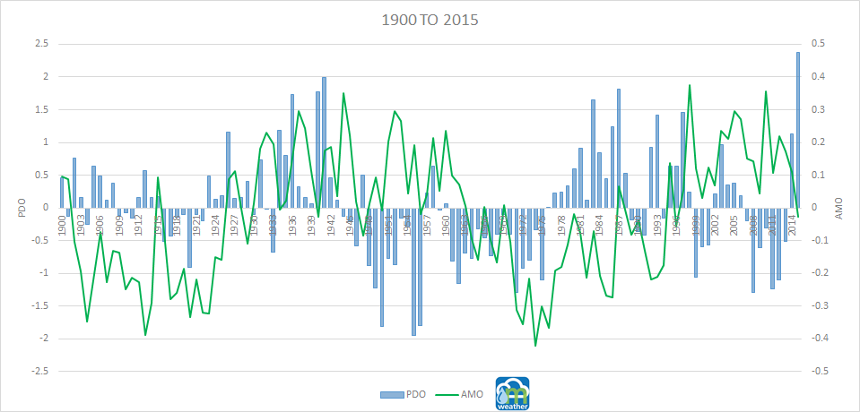
The PDO (Pacific Decadal Oscillation) and AMO (Atlantic Multidecadal Oscillation) are longer term cycles, decades, which relate to drought frequency over the US.
The PDO is currently in a long-term negative phase, and the AMO in its long-term positive phase. However, leading to and through winter the PDO shifted to a positive phase (temporary value changes like this are historically common and not out of the ordinary). Regardless of PDO phase, the AMO remained positive leading to our winter and March. In these phases, a drought is most prominent in the red shaded areas. (Maps C and D below).
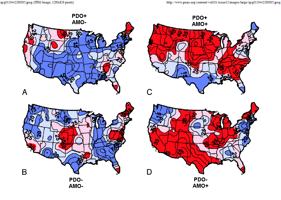
The momentary shift to a positive PDO has little effect on the eastern plains, but does on the U.S. – notably Texas. Texas should have more frequent rains in this setup, and that has been the case if you look at that March or January to March precipitation map from above.
So, Colorado may have had a nice change of pace in the winter to a wetter one, but that clearly didn't last and didn't benefit the mountains.
Going forward long-term (years), we are still in a drought and the frequency of drought will continue to outweigh frequency of surplus.
Going forward short-term (months), we may again see a wetter than average period. We could see this period developing now, to help the late spring and early summer.
Some hopeful indication appeared in later March. The AMO shifted negatively. Combine a positive PDO, the frequency of drought will be cut way down across the entire country. (Map A in the previous graphic). This impact depends on if the AMO can "hold onto" the negative phase – time will tell. This would be of great benefit to the southwestern US, and the state.
Despite momentary wetter periods remember that the long-term pattern may not shift again for another decade or two. The PDO won't change phase for the long-term until 2035ish, and the AMO in 2025ish.
With long-term droughts being frequent, you can plan on temperatures remaining warmer than average for the state too.
In this extended period of drought, our fire danger should be tracked closely. Through March, this year is reminiscent of 2012 and 2013. While we remain more optimistic about the coming months here at wx5280, it's worth noting that both these years had historic fires across Colorado. I'm digging through that data for a future post.
*El Nino could be brought into this discussion, but there is a correlation to the ENSO phase and the PDO phase, so I've already kind of covered it...indirectly.