For a Significant Spring Storm, The Devil is in The Details

As we continue to narrow in on what looks like a significant spring storm somewhere along the Front Range and eastern plains, let's remember to slow down and take things in stride, as the forecast will likely continue to evolve over the next 24 hours, and probably beyond. While confidence continues to grow that somewhere sees big rain and snow, the devil is in the details.
We, both figuratively and literally, have a lot riding on this storm. The state NEEDS the moisture, and the more widespread this thing ends up the better. A miss here would be a big hit with wildfire season getting underway. A bit more personally, if you've been following along with our narrative you'll know this system would go a long way in verifying what the points we've been trying to make and the analogs we've been discussing for months now.
Overview
If you missed our update yesterday, a lot still holds true. A large upper level low is progged to drop into the Four Corners region late Wednesday and slowly drift east over the following days. Impacts will vary (perhaps significantly) based on eventual track and intensity.
Our system is currently located over the northwest US and will continue to dig south and east over the next 24 hours. You can see the dip and clouds in the image below:
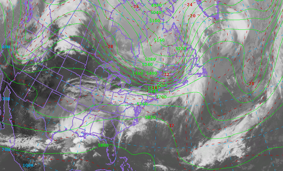
Yesterday we suggested models would start to get their act together last night, and while this happened to a degree, there is still much uncertainty with this system.
First, the GFS continues to be the outlier in how it handles the upper level feature, bringing it through as an elongated trough instead of a closed, concentric upper level low, and therefore keeps most of Colorado relatively dry. Based on how other models are handling this, current observations, and even how its own ensembles look, we continue to think this is not the most likely scenario. For the time being, the ECMWF, GEM, and UKMET operational solutions seem to better align with the ensembles and seem, for the time being anyway, more likely.
What does this mean? Greater odds we see a significant precipitation event somewhere along the Front Range and eastern Plains.
Wednesday
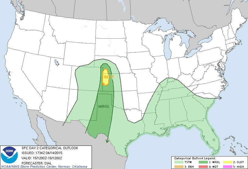
Ahead of our main event we may see a few strong storm develop Wednesday across Colorado, especially over extreme eastern portions of the state. The Storm Prediction Center has issued a marginal risk for severe storms across extreme eastern CO, with a slight risk for severe storms across western Kansas and southwest Nebraska. The main severe threat will be strong winds and hail.
Precipitation chances across the I-25 corridor are a bit more questionable for Wednesday afternoon, but in general chances increase Wednesday PM through Thursday for all of the forecast area.
Thursday, Friday, Saturday
Here's where things remain tricky. Depending on which solution verifies, these three days ma look very different. For now we'll continue to broad-brush the entire period with a chance for rain and snow, and continue to narrow in on how this might evolve going forward.
If this storm is going to materialize, this will be the time period we we see the heaviest rain and snow.
Can it snow, will it snow, will it accumulate?
We are getting a lot of these questions, and the simple answers are yes, probably, maybe. Yes, it certainly can snow this time of year – even after the warm temperatures we've been having. April is Denver's second snowiest month on average. Will it snow? Wherever we see the core of the precip setup we will likely see snow, even at lower(ish) elevations.
Will the snow accumulate is an entirely different beast, and really depends on a lot of things. First of all, most of the snow maps floating around are based on 10:1 snow to liquid ratios, which will likely be a bit high for this system where rain does change to snow. Something like 8:1, or event 6:1 will be more probable – meaning 6 to 8" of snow for every 1 inch of precip. Then there are issues with ground temperatures (they are very warm!), air temps (they will be marginal!), and of course high sun angle. As we've seen time and again, high intensity snow, overnight snow, and long-duration events can overcome a lot of this – leading to accumulating snow late into April and even May.
For this particular system I think a of the bigger population areas would see snow if they end up under the bullseye for precipitation. Accumulating snowfall will certainly favor areas along and west of I-25 and the Palmer Divide where elevations are higher, but can't rule out snow/accumulating snow east of the interstate as well. For now it looks like during the day the snow line may climb to around 6,000 feet, but drop lower during overnight hours.
Keeping score (model geeking)
- GFS. The GFS continues as outlier with minimal precip event elongating the splitting the upper level energy as it moves over Colorado. Its ensembles continue to look much closer to the other models, with a much more tightly knit low moving across northern New Mexico Wed -> Sat. We will continue weight the GFS operational lower than other models until we see a more convincing reason to believe it. That said, it's getting kind of stubborn... so something that needs to be watched for potential bust!
- ECMWF. The EURO continues to look impressive. Its biggest run-to-run changes seem to be in the eventual path of the low, but intensity and overall look remain pretty steady. Today's 12z EURO focused the core of the precip along and north of the Palmer Divide, with a widespread 1 - 3" precip event for all of northeast Colorado and >6" of snow for Denver.
- UKMET continues to look very solid with a similar look to the EURO/CMC favoring northeast Colorado for heaviest precip, but bringing pretty good widespread totals statewide.
- CMC. The Canadian continues to be VERY impressive, but is often overdone. In many respects it looks a lot like the 12z EURO, though with a better secondary bullseye across southern/south-central Colorado. The CMC covers nearly all of eastern Colorado in >1" precip through Saturday night, with a very impressive foothill snow (>15") and heavy snow for Denver and Colorado Springs as well.
- NAM. The NAM is a bit more streaky with precip, but the overall track looks similar to the CMC/EURO. Its 12z run was further south, and then with 18z it pushed the precip bullseye into Wyoming and Nebraska. We continue to think this is wrong, and a more southern solution will be favored in the end.
- SREF. SREF plumes are always fun. Currently producing anywhere from 6 to 15" of snow along the urban corridor, the model is usually a bit bullish. It does help somewhat with confidence, however, as it helps to discredit some of the drier solutions. SREF means put a widespread 1 - 3" QPF across all of eastern Colorado through 00z on the 18th.
More generally speaking, I think the consensus around here is that in the end a more southern solution will be more likely than a northern one given current atmospheric setup. It's interesting to see some shifts in today's models to the north, however, so this will certainly be something we'll be watching for in tonight's runs.
Bottom line: there's still too much uncertainty to be too specific on rain/snow totals. While it looks like most folks will see some precipitation with this event, it looks like there will be a bullseye or two of significant precipitation (>2"), where exactly this ends up is the big question at this time.
More data on the way this evening and tonight where we'll continue to narrow in on the details here and pass along updates as needed. For now plan on some changes moving in by Wednesday, and keep a close eye on the changing forecast for Wednesday night and beyond! As always, subscribe to Weather5280 to be sure not to miss any updates!
More to come...