Advisories Posted, Snow on the Way, Latest Forecast

There is little change to the going forecast for today, as our system remains on track to bring a quick hit of rain and snow to northeast Colorado tonight and into Wednesday.
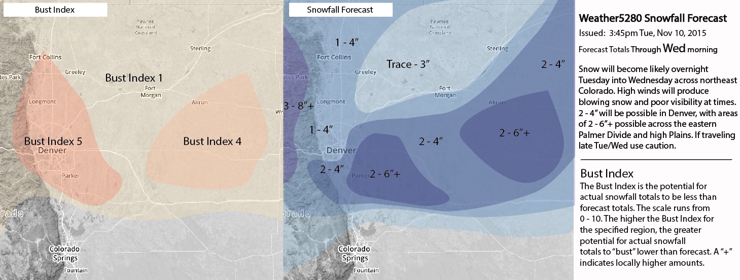
Overnight the National Weather Service issued a Winter Weather Advisory for Denver, calling for 3 - 6" in Denver, with 4 - 8" for the southern suburbs and Palmer Divide. While we're certainly in agreement that the southern portions of metro extending east along the Palmer Divide will stand a better chance at more snow than Denver – we'll resist the urge to up our totals for Denver proper too much, and continue with 1 - 4" for the north/northwest metro (including downtown), and go 2 - 4" for south-central Denver.
This is due in large part to believing winds will quickly become unfavorable for the city, and limit our snowfall overall. Could we end up on the high end of our forecast? Or course, but we think the low end is equally likely, if not more so. Models continue to show downsloping winds along the I-25 urban corridor, with more snow directly to the west and east:
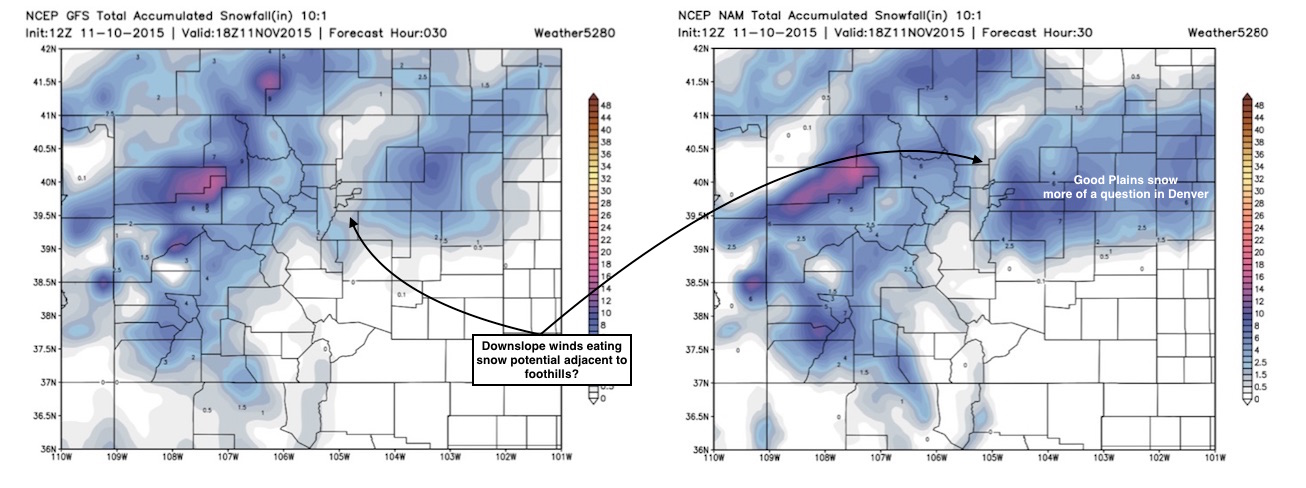
Latest SREF means show a tight gradient across the city as well, reiterating what the NAM/GFS are showing above. It's producing nearly 6" for DIA now, while 3.5" for northwest Denver. You'll note that the NAM above shows some very heavy snowfall totals just east of DIA, we'll need to keep an eye on a 'bust high' bullseye somewhere in the area.
We'll go ahead and drop the Bust Index a bit for Denver as we think most locations will be able to meet the low-end 1 - 2" range. As this is a very dynamic system some heavy snowfall rates will be possible, and quickly accumulating snowfall could overcome the short favorable duration of the event. This would also lead to highly variable snowfall totals across the region. Lastly, we'll go ahead and expand the area of 2 - 6" a bit for the eastern metro and immediate Plains. Here's our latest forecast:
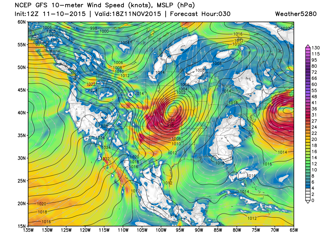
The wind associated with this system continues to look like it'll cause more issues than the snowfall totals themselves. The National Weather Service has issued a Blizzard Warning for the northeastern Plains of Colorado, with winds from 25 to 40mph expected to develop overnight, and gusts upwards of 55mph. Travel along I-70 and I-76 east of Denver Wednesday morning will be treacherous, keep an eye our for latest closures and delays, and postpone travel plans if possible. In addition, wind chills may be in the teens at times Wednesday morning.
Behind the snow temperatures will be cold. Highs Wednesday will remain in the upper 30s and low 40s across the region, with overnight lows in the 20s. We'll slowly warm as we head toward the weekend.
A tricky setup unfolding over the next 24 hours to be sure. This storm has looked very good at times and very bad at times if you're hoping for snow, with somewhat of a mixed signal as we head into the event. Remember Matt's words of caution yesterday, and if all works out and you do wake up to snow Wednesday, enjoy it, and please, travel safely!
We'll pass along any urgent updates on our Live Blog tonight and Wednesday, otherwise plan for a quick taste of winter tonight, and send along your storm reports!