Thursday PM Update: Tracking Next Winter Storm

In many respects there aren't too many changes to what we discussed in yesterday's update. We are still tracking the potential for a strong winter storm by late in the weekend and early next week, but many uncertainties remain, and a heavy snowfall event for Denver is far from a done deal. We thought it would be good to get another update out this afternoon, reiterate some points, and show a bit more of how this setup is coming together.
First, everyone who's throwing snowfall totals around today should likely go ahead and throw them out. Even with decent agreement between the models, it's simply too far out to be speculating too seriously about totals. In fact, even some models that agree more or less on snowfall totals – get there in very different ways, which may be a concern.
The models
There remains several key differences in how the global models are handling things from Sunday afternoon through Tuesday morning. However, thus far, the trend has been for models to come toward the GFS. Two days ago while the GFS developed a strong negatively tilted trough across southeast Colorado(good for Denver snowfall), the GEM/EURO were nowhere close (both were open, weaker, and progressive, faster). We now have decent agreement here, though each are tracking the storm's center slightly differently - north/south.
All three models are in agreement that a large upper low carves itself out across the Great Basin Sunday night, then tracks east along (or near) the southern Colorado border through Monday night. The operational GFS is at the moment further north with this low, tracking it into extreme southeast Colorado by Monday evening, while the GEM/EURO are a bit further south.
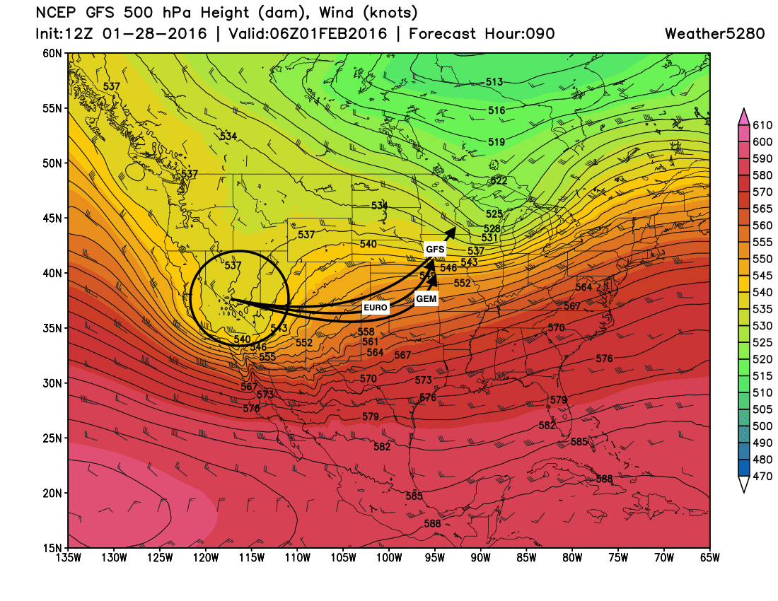
Given this, the GFS develops a surface low in almost "ideal" location for heavy snow along the I-70 corridor across the eastern Plains by Monday evening, while EURO/GEM are a bit further south – favoring southern Colorado by Monday evening for heaviest precipitation.
Given that all models are suggesting this trough well become negatively tilted (energetic, developing) as it intensifies over southeast Colorado, or thereabouts, gives greater confidence in some of the snow totals models are producing This will help enhance a deep upslope flow along the Front Range by 00z Tuesday.
So what's up with the EURO?
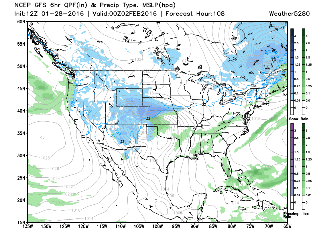
The EURO continues to suggest heavy snowfall already impacting the Front Range by Sunday evening and overnight, due in large part to a strong 700mb front that's progged to move through the region Sunday afternoon, and overrunning.
We're exercising caution, typically overrunning won't produce such widespread heavy totals as indicated by the EURO at this time but it's something we're watching. Bledsoe pointed out this afternoon, that sometimes this very strong fronts will over-produce down toward Colorado Springs.
That said, while yesterday the EURO brought most of Denver's snowfall Sunday night, and tracked the main upper level feature too far south Monday into Tuesday, it's since come a bit further north (closer to the GFS), and while still further south, would keep snow going over most of eastern CO into Monday night.
The ensembles
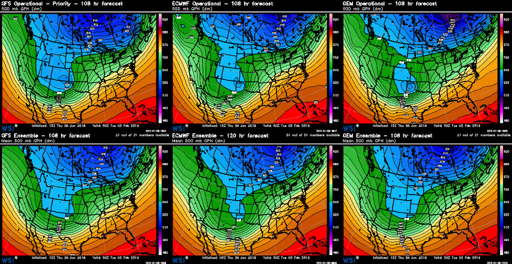
So, while we watch the subtle differences unfold between each operation model run, we keep a close eye on their ensembles. All of which are in reasonable agreement, and pretty close to what each operational model is forecasting at this time - perhaps only a slightly weaker system.
Here's a look at the GFS/ECMWF/GEM ensemble forecast for 500mb at 00z Tue (Monday evening). Note they all look very similar. The GFS (left) has the low centered further north (across southeast Colorado), the EURO (center) a touch further south, and the GEM a bit southeast of both.
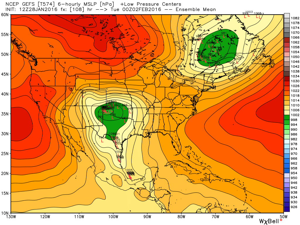
At the surface, here's the GEFS ensemble forecast by 00z Tuesday. Each "L" shows a position of a an ensemble member's low at that time. Notice the cluster over the Oklahoma panhandle, and they the ensemble is actually a bit further south of the operation we pictured above.
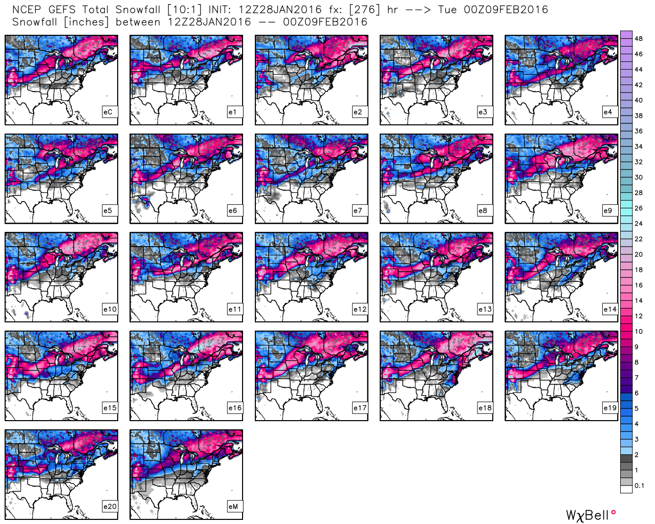
Each of these different solutions, derived from slightly different initializations, produces a different forecast for our area. The map below shows the snowfall forecast for each one of these ensemble members. Note that just like the Low map above, there's good consistency for a good snow across Colorado, but each is still slightly different. In fact one (E5) producing nearly no snow for Denver (!!!), though is an outlier member for now.
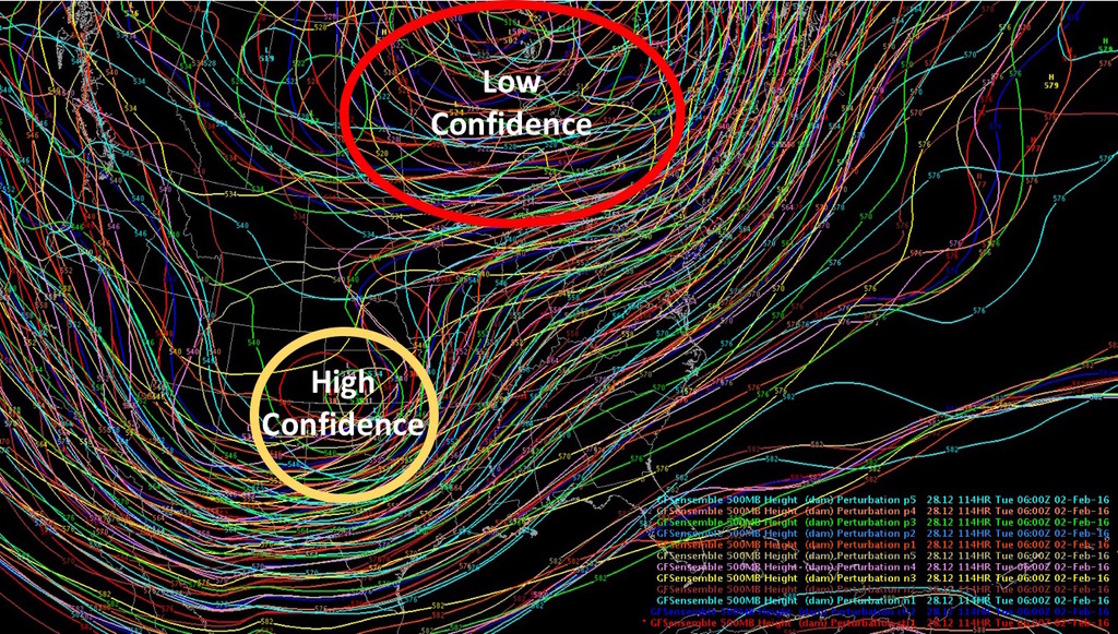
Lastly, while ensembles have been fairly consistent (especially the GFS) with the Colorado low, this has not been the case with the forecast for the Hudson low at the same time. If we look at this image produced by Sam Ng this afternoon, notice the consistency in the forecast across southeast Colorado, while it's much more scattered over Hudson Bay. The idea here, is that if the Hudson low is quicker to move through, so too will be the Colorado low, which would hurt the bullish snowfall forecast from the GFS.
Whew!
Bottom line
Bottom line is we're still several days out, and storms that look promising have a way of falling apart when we get within three days of the event. However, the potential for a significant winter storm across the region is there from Sunday afternoon through Tuesday, so we'll continue to watch closely and offer many updates in the days to come.
Thursday takeaways
- Better model agreement today than yesterday with all the global models bringing a negatively tilted trough through the region from Sunday night through Tuesday.
- Storm track remains a big question, a difference of just a hundred miles can mean the difference of a few inches of snow in Denver vs a significant >8" snowfall.
- EURO is playing games with snowfall Sunday night, but TBD if we buy this scenario. Interestingly enough, the Canadian has a pocket of heavy snow north of Denver too, despite tracking the low furthest south of any of the models...
- Areas for concern if you're hoping for big snow include the fact the EURO may be overdoing snowfall totals with initial front Sunday night, and is much less favorable for snowfall in Denver (though getting better) Monday and Tuesday. Also some concern that models are over producing QPF given how far south the low may end up. And of course... still being 3+ days out, many things can and will still change.
- If you want snow don't look at the DGEX, and likely root for the 12z operation GFS solution.
- Yes, it's very warm out there today, and will be so through Saturday. Get out and enjoy!
Much more to come... subscribe now, and stay tuned!