Saturday Afternoon Update: Another Look at Modeled QPF; Notes on the Forecast

After a very robust run of models last night and this morning, our confidence continues to grow in a major winter storm that will likely impact many people. So, while we track snowfall potential tonight and Sunday across eastern Colorado, here's an afternoon update on what we're calling the main event – the potential for heavy snowfall Sunday night through Tuesday.
Right off the bat, I want to REALLY emphasize something...THE STORM IS STILL IN THE PACIFIC OCEAN! For all the model analysis and pontificating, we really haven't even sampled the storm accurately, which is especially important when forecasting in the west. That comes very late tonight and Sunday. Once we get quality sounding information on this storm, model confidence will continue to increase and we can really put a nail in this one...one way or another.
Let's look at some eye candy...
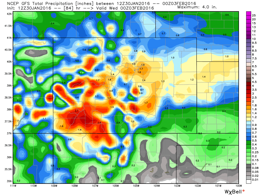
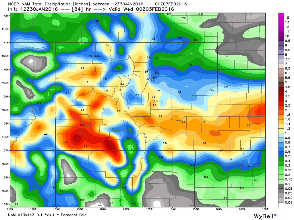
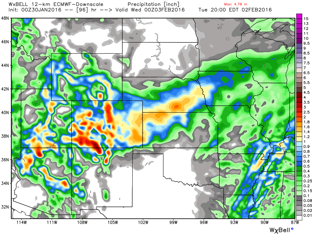
Total Liquid Precipitation Forecast Through Tuesday
GFS Model (of note: the 18z GFS came in well north of this...):
NAM Model:
ECMWF-WRF Model (last night's run):
CMC Canadian Model:
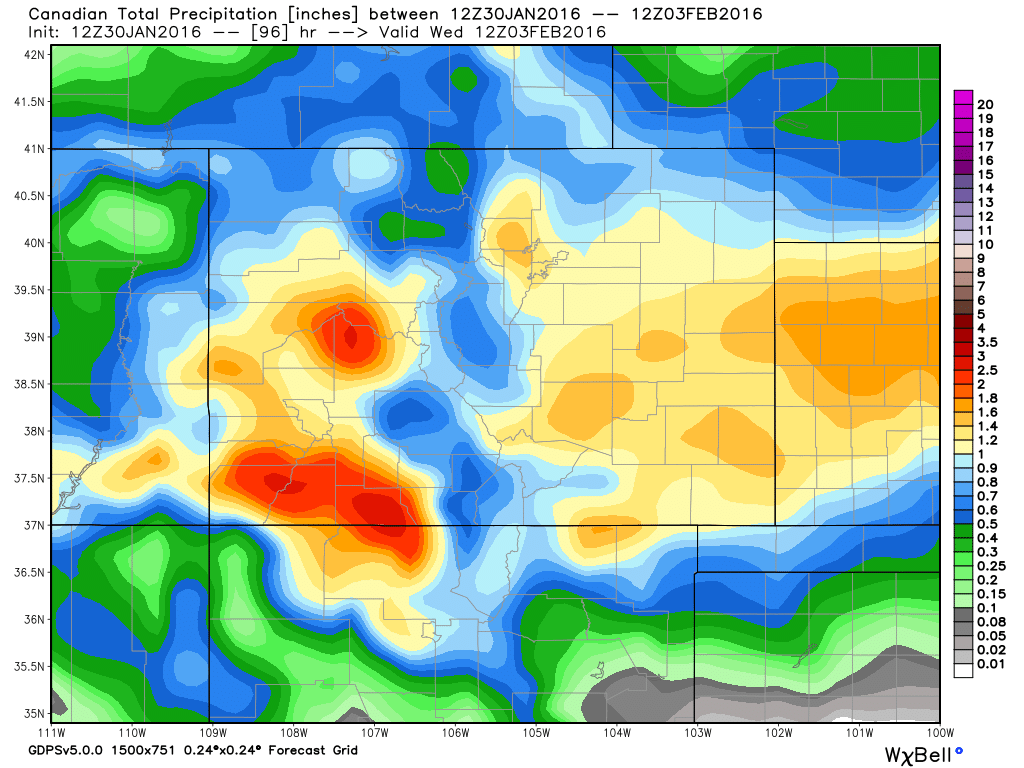
Yes, that would end up being some serious snowfall for many of us. With liquid to snow ratios likely ending up around 15:1 during the main part of the storm, many locations across eastern Colorado would end up with over 10" of snow. Some folks would end up with over 16" of snow, and a few of us would end up with over 20" (!).
However, you can clearly see what the different models are doing. Some favor south, some favor north, some favor everybody...which is why it is still too early to put out our OFFICIAL expected totals map here at Weather5280. Per usual with storms like this one, a slight shift in the upper level low will have HUGE implications for who sees how much snow.
Another thing that will help greatly is seeing exactly how the situation unfolds tonight and early Sunday. If it ends up not doing much, then we can solely focus on the Sunday night - Tuesday timeframe as the time that will contain ALL of the snow. Per our post this morning, that part of the equation is still in question.
We also want to stress that folks should "BE PREPARED, NOT SCARED". There is no sense freaking out about this winter storm, until we get more quality data and can weed out more of the uncertainty. That being said, travelers should certainly have a "plan B & C" as airlines will no doubt be canceling flights early. Ranchers, you do what you do... make sure your livestock has shelter, adequate feed, and water. If you don't, this is the type of storm that will kill many cattle that are left to the elements.
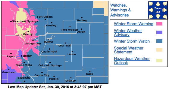
The National Weather Service has issued a Winter Storm Watch for ALL of Eastern Colorado from Sunday night through Tuesday. This indicates that there is potential for significant snow and wind.
Again, amounts in question, but potential is certainly there... More model information will stream in this evening and we plan on posting a late evening update. For all of us weather nerds, this is certainly an awesome one to follow and forecast. Stay tuned!
Also, who's felt that cold front?!