February 2nd Snowfall Totals for Northeast Colorado and Winter Storm Recap

Needless to say, we're very happy with how the forecast turned out after what was a long week of piecing together what would eventually become a strong winter storm for Colorado, delivering anywhere from 5 - 16" of snow to northeast and east-central Colorado, with upwards of 20" recorded in some foothill communities.
Our forecast for Denver, Colorado called for 7 - 14"+ of snow. As of 11:00am this morning Denver International Airport, where official records are kept, had recorded 11.3" with light snow continuing for much of the morning.
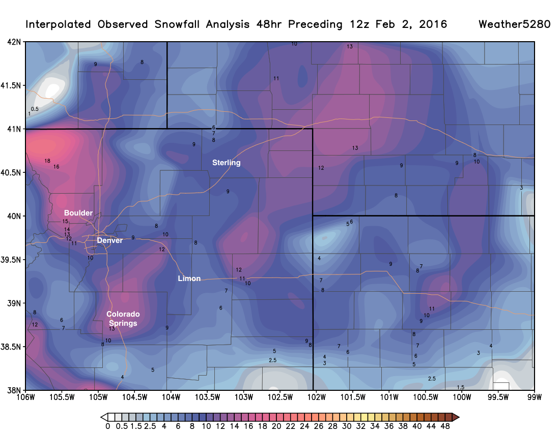
Here's the latest interpolated snowfall totals map for our area. For many of these locations you can add an additional inch or two these totals as light snow continued off an on since early this morning. Fort Collins, Boulder, and Colorado Springs were the winning snowfall cities along the Front Range with this storm.
Upslope, we love you
It took some time for a good, true upslope flow to develop across the northern Front Range, but last night it finally did. Yesterday afternoon we issued an update reassuring folks that the best snow had yet to fall for most of us across northeast Colorado, and sure enough that proved true.
For much of the day winds had a southeasterly component as our low was still west of the region. This meant great snowfall for Colorado Springs, which ended up receiving upwards of a foot of snow in many locations through yesterday evening.
Here was the surface map late in the afternoon Monday, winds were starting to shift around to the east (gold barbs), but you can see they were still shifted a bit out of the southeast, and right around Denver snow was light to virtually non-existent:
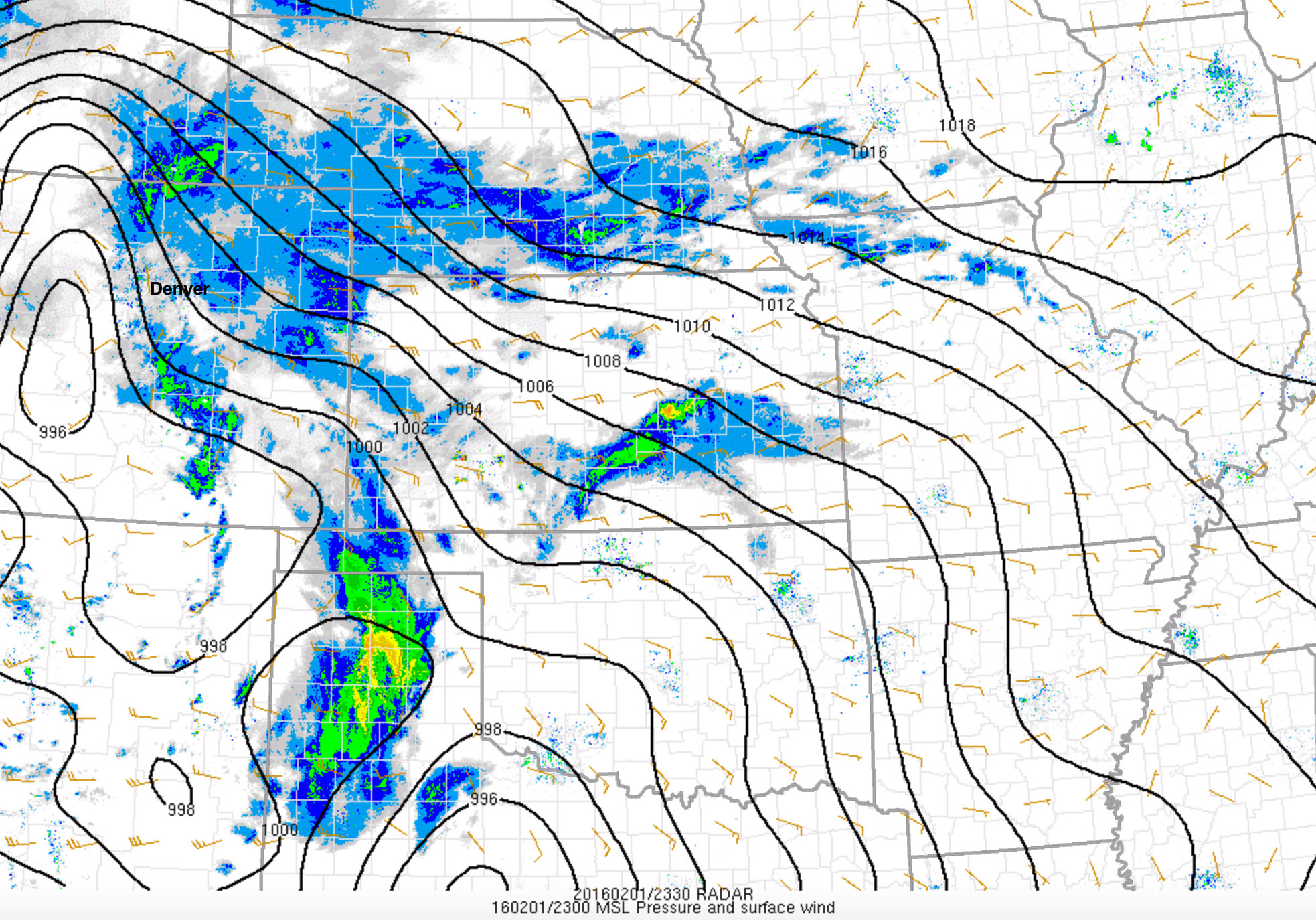
By 7pm winds were almost due east and we see upslope become enhanced along the Front Range foothills, and snow began filling in around Denver too:
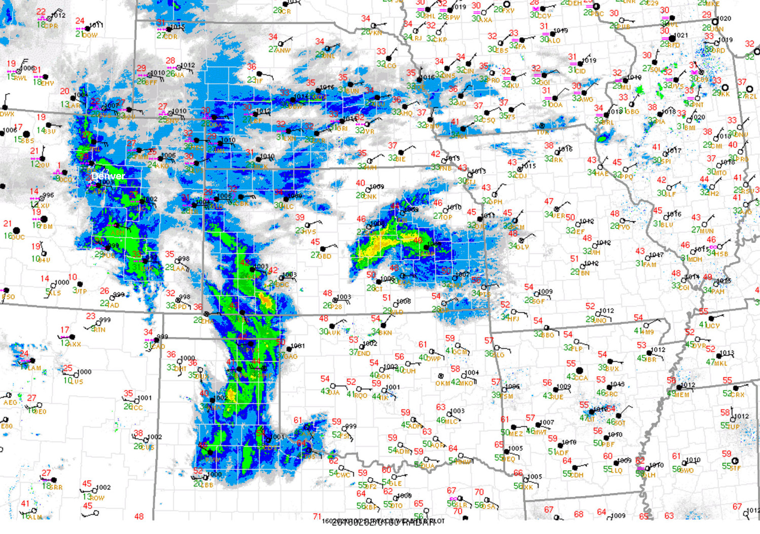
Eventually a strong upslope flow developed as our low finally moved east of the area. By 9pm last night the low had developed in an optimal location across southeast Colorado for upslope snow across the Front Range, and a powerful snowstorm with strong winds had shut down the interstate from Denver to Kansas.
The band of heavy snowfall that worked through Denver last night was awesome, if you had the chance to get out and enjoy, hooray! This band of snowfall developed along the foothills during the early evening hours, then eventually shifted east by about 10pm last night:

And of course all this was made possible by a very favorable storm track at the mid levels. Here's a look at each initialization of the GFS as our storm came onshore Sunday through this morning as it pushes east of the area. Just about how I would have drawn it if I controlled the weather! The storm stayed well on speed and track throughout the forecast process and the models had a really good handle on it for the past several days, despite shifts in QPF placement.

Snowfall Totals
In the end we had ourselves a great eastern Plains snowstorm. The biggest bust for us came in the mountains southwest of Denver, but otherwise totals aligned as expected. Here's a look at some totals from across the region, and our forecast:
| Location | Forecast | Total | Bust? |
|---|---|---|---|
| Genesee | 12 - 20"+ | 22.0" | 👍 |
| Nederland | 12 - 20" | 19.1" | 👍 |
| Breckenridge | 12 - 20" | 12.6" | 👍 |
| Tiny Town | 12 - 20" | 12.8" | 👍 |
| Elizabeth | 8 - 16" | 17.1" | 👍 |
| 1mi E Castle Rock | 8 - 16" | 13.2" | 👍 |
| Green Mountain | 7 - 14"+ | 13.5" | 👍 |
| Denver (official thru 5am) | 7 - 14" | 10.4" | 👍 |
| Weather5820 (Denver) | 7 - 14"+ | 8.25" | 👍 |
| 3mi West Fort Collins | 7 - 14"+ | 15.0" | 👍 |
| Watkins | 7 -14"+ | 12.2" | 👍 |
| WNW Boulder | 7 - 14"+ | 16.2" | 👍 |
| 1mi SW Westminster | 7 - 14" | 11.6" | 👍 |
| SE Aurora | 7 - 14" | 9.5" | 👍 |
| Greeley | 6 - 12" | 10.0" | 👍 |
And here is a snowfall totals interactive map that you can explore. Totals are both from CoCoRaHS (through 7am this morning) and NWS local storm reports, last updated at 9am this morning:
This was a great storm for the snow lovers out there, to be sure. And despite some folks lowering their forecast totals yesterday, we're glad we stuck to it and in the end the system performed just about exactly as expected. We have LOVED the interactions with all of you in recent days, and although many of you have already shared your storm reports with us, we'd love if you add them to the comments below!
Some pockets of light snow will continue for a few hours across the region, but little additional accumulation is expected. Enjoy the snow day!