A Return to a More Active Storm Track For March?

Outside of the first few days of the month, February has been mostly a sleeper for winter weather across Colorado. Of course we saw some good snow in the foothills earlier this week, but otherwise it's been quite warm and mild across eastern Colorado. There have also been a few systems over recent weeks have kept enough snowfall going in the high country to keep basin snowpack at pretty healthy numbers all things considered. Currently every basin in Colorado is reporting at or above average snowpack, generally 100 - 106% of normal across the board.
March is a crucial snowfall month of Colorado, and in El Niño years that's often even more so true. March is also Denver's snowiest month on average, so naturally the question is – what about this year? Though the month averages 11.4" of snow in Denver, many recent years have fallen well short of this number. In fact, just three Marches of the last 12 years (dating back to the big blizzard of '03) have seen above average snowfall, the last coming in 2013, when 23.5" of snow was recorded at Denver International Airport.
If you've been following along since last summer, you'll know we think the storm track will pick up for March and April across the region. Of course, given the stubbornness of the western ridge of late it's been a bit difficult to push this idea too hard. As we've said several times over the last month, if we get to the end of February and the medium range models continue to look the same – then we worry. Over the last several days there have been some movements here, finally, and while not a slam dunk, there's at least some indication that things will start to shift as we head into March.
Teleconnections
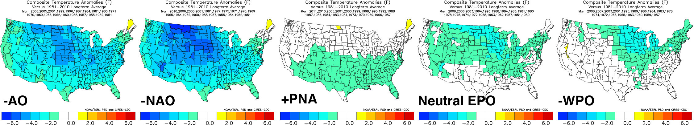
Despite the fact that many of the operational models aren't picking up on it, teleconnections continue to look favorable for a cooler period across the central United States as we head into the end of February and on into March. Given the torch that has been much of this winter, if I were a betting man I'd probably stay away from forecasting prolonged epic cold... but that said, with the AO, NAO, EPO and WPO all set to go neutral/negative, and PNA positive, it's hard not to see the potential for a chillier air across the central U.S. over the next 30 days or so. Here's what each of the current teleconnection forecasts would typically lead to in March:
MJO
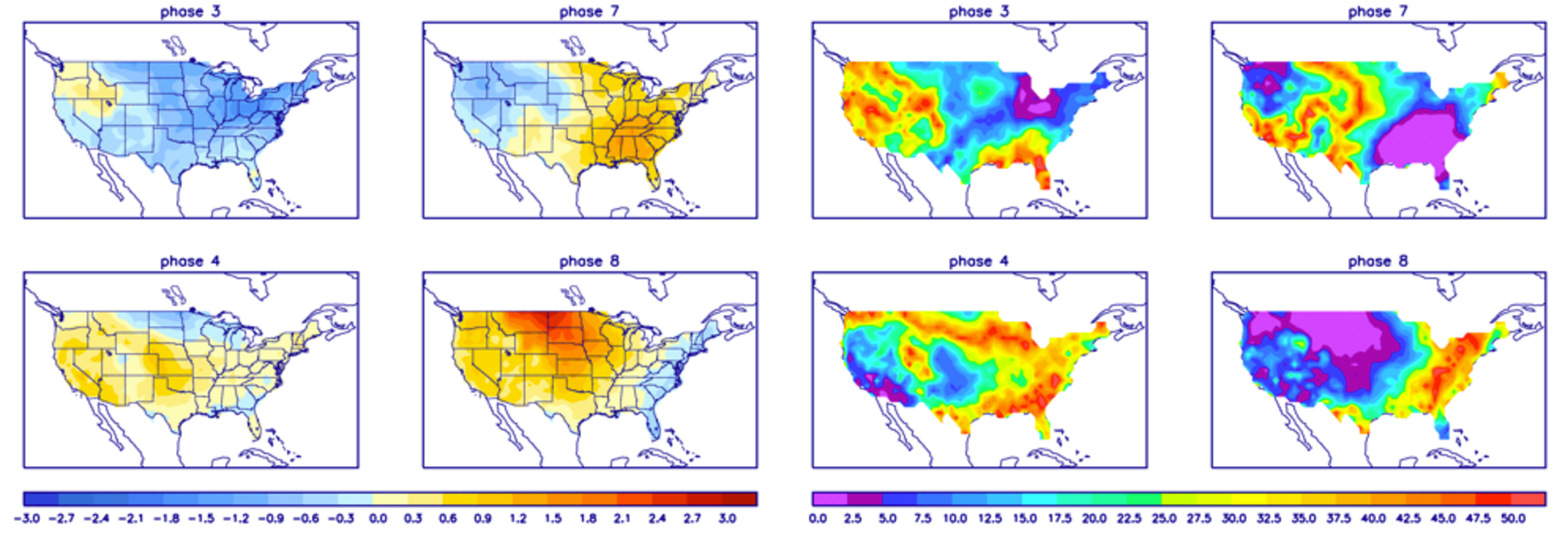
It'd be an understatement to say that there are many conflicting signals right now. From teleconnections, to the MJO, to global models trying to make sense of anything beyond day three... it's a mess. Currently the MJO is in phase 7, and is forecast to remain there or drift into phase 8. If we take a look at temperature composites centered on March, we see phase 7 would have cold in the northwest and warm east, while phase 8 is major torch for most of the U.S. Neither of these patterns are what we are seeing now, and if the teleconnections (above) are showing anything, it's the opposite of what you'd expect for phase 8 MJO in March. Also, if true, this would be a winter killer around here next month... Following phase 8 the MJO may get into 1 and 2, the question is if the signal will fade too much by then. These phases are better for us in March.
Medium range models
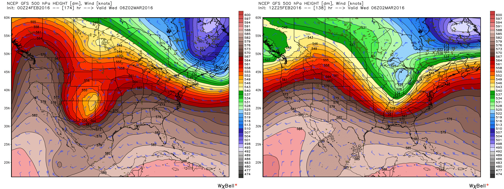
Let's be honest... Since they absolutely nailed the late January and early Februay storm, the medium range models have generally been a disaster. They've been very good at forecasting the persistent ridge. But whenever a disturbance crashes that ridge or moves around it, they have not been accurately forecasting what said disturbance would mean for us. Over the next few days we'll continue to see a good warm up across the intermountain west as ridging reestablishes itself to to end the week and this weekend. As we get into the weekend we see the first of several disturbances race across the west – this first one looks like it'll likely stay north of Colorado, but may bring some much appreciated snowfall to Idaho, Utah, Wyoming and the likes.
Right on its heels another trough will dig into the northwest, and this one at times looks like it could take a more favorable track for us, and in a lot of ways it looks a lot like our system earlier this week. Of course the details here are fuzzy... earlier this week the GFS slammed eastern Colorado with heavy snow, but has since backed off considerably. Both the CMC and EURO have this trough too, but neither are too impressive for the time being. Their ensembles keep the trough pretty progressive/quick before closing it off well east of Colorado, which would lead to a quick, blustery cool down early next week, but not a ton of snow. We'll see.
This similar pattern looks to repeat itself at least once more by the end of next week, with the Canadian and EURO operational models pulling in yet another, stronger ULL into the west by day 10 or so. Of course, today's 12z GFS looks nothing like this (it pumps the ridge on day 10), but the point is, the door is open to some more interesting weather as we head into March.
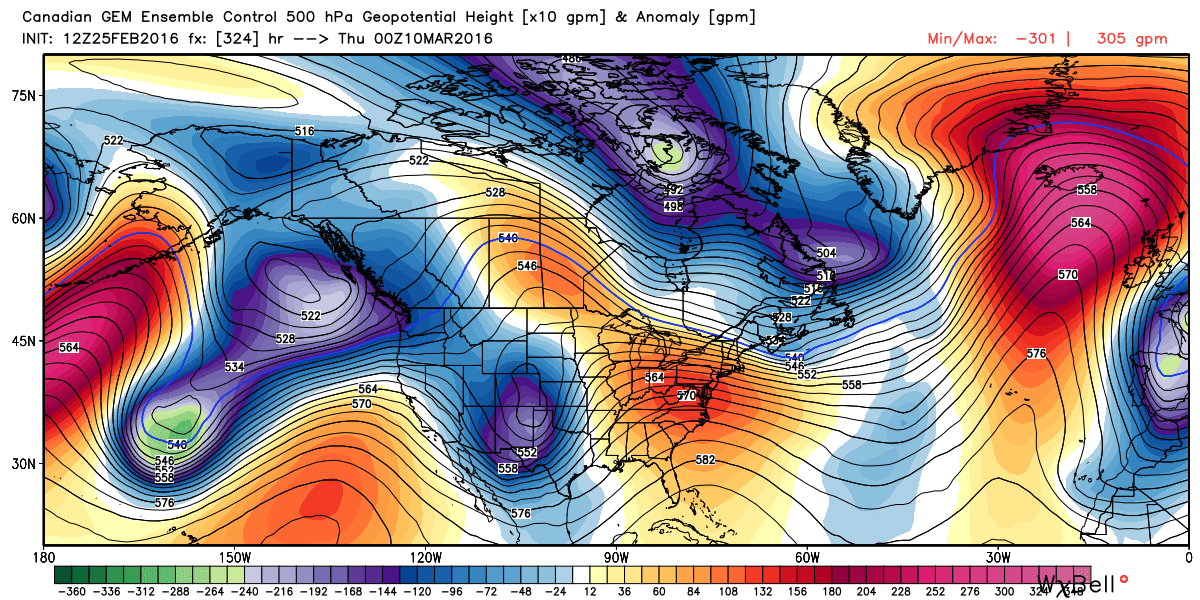
Lastly, the medium range ensembles are also showing signs of life by the second week of March, with the last few runs from the EURO putting a pretty big trough in the west. Yesterday's European Weeklies also came in looking pretty darn active and cold for much of the United States for March, including a similar looking monster trough by the second week of March in the west. While I typically don't put a ton of stock in the Weeklies... it is another boxcar in the active-March train, so at least that. Of course we can't share with you the Euro ensemble maps or Weeklies, but below is the Canadian ensemble control for March 9, showing that same trough...
While it is always easy to focus on what the models are telling you, it is much tougher to focus on what they aren't telling you. We are entering a time of seasonal change and greater variability. Thus, the models have a harder time wrestling with the more complex details. March is always a prime time of year to stay current with the forecast.
So, snowy March?
Now, if we can't get one of these next several systems to line up for us, or the ridge remains too stout in the west, we may end up waiting until the middle part of March to late March before things get more active. It continues to look like a strong southern storm track will kick in at some point during March (maybe sooner than later), which at least leaves the door open for a good Colorado snowfall.
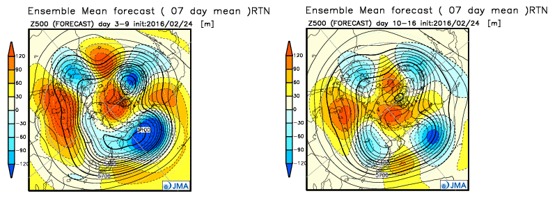
The JMA, which really has been pretty good all winter, shows this. Week one (left) shows big time ridging continuing to dominate the west in the means, but by week two (day 10 - 16) we start to see a path for a more active southern storm track.
Of course, none of this means anything if instead of missing storms that go up and over the ridge like we are now, we watch them all dig too far south for the month of March.
Anyway, despite nothing concrete showing up in any of the modeling at this point (Thursday's modeling looked just shy of awful for snow lovers in Colorado through early March), I do think there's good reason not to give up quite yet. The ridge looks to break down over the next weeks, El Niño continues to weaken, and with that it could be off to the races. At the very least there are conflicting signals in the medium range, and not JUST ridge... which at the very least leaves the door open for something sneaky. We'll keep a close eye on early next week, as despite models backing away from it in recent days I think there's still a chance it gets its act together for us, and then we focus on what March may actually do for us around here, or not do.