Another Toasty Weekend Ahead, But Changes for Next Week?

After weeks of unseasonably warm weather, it almost seems as though winter is long gone and we should instead be talking about summer heat and convective storms. March, however, has a sneaky way of suddenly delivering a wintry punch, just when you think there's no chance at all.
As we've discussed at length, we fully expect(ed) March and April to deliver moisture (rain or (and) snow to Colorado), as the El Niño weakened and the western ridge finally began letting storms through. So far we've seen the breakdown of the western ridge, but admittedly very little resembling an active storm track for much of Colorado.
With the ridge relaxing, California as started the month very strong with regard to rain and snow. Below is a map showing the month-to-date precipitation totals for the United States. You'll note across much of eastern (and southern Colorado) it's been quite dry, but portions of our northern mountains, and the northern urban corridor picked up some decent moisture with last week's system.
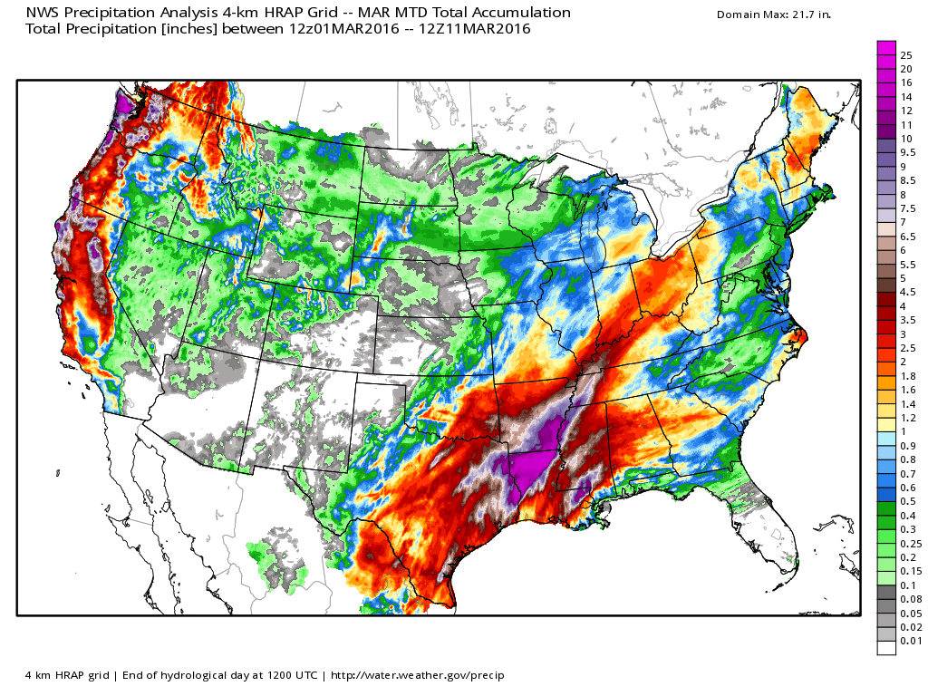
Through the first 10 days of the month, however, storm have generally missed Colorado. We missed the monster trough that first slammed California (it went well south, see map of south-central U.S. above), and since then there's been little opportunity for anything around here.
Weekend outlook
This weekend we'll see another system pass along Colorado's southern border, but it won't produce much meaningful precipitation for the state, just some scattered mountain snowfall, and perhaps a few showers or thunderstorms across the Plains. Temperature will remain well above normal through the weekend.
Next week
As we head into next week we come to the halfway point in March with little snow to speak of for the state. Combined with warmer than average temperatures, this is obviously bad news for snowpack, as we typically peak around April first in the mountains. So the question is – is there any hope for moisture next week?
The answer in short, is yes. But, there are huge differences in modeling that in turn have huge impacts on how great that chance is for the state.
We'll see a couple of systems traverse the region next week. The first of which comes during the Monday/Tuesday timeframe, and looks – for the time being – like a relatively low-impact event for the state. The northern mountain stand the best chance for snowfall with this system, as well as perhaps some showers across northeast Colorado.
The second trough moves through later in the week (likely Thursday-ish), and will be system "to watch" over the coming days. The differences in the modeling for late next week is painful, but all the global models generally agree on a pretty strong cold front marching across eastern Colorado, and with it likely our best chance of snow we've seen in several weeks.
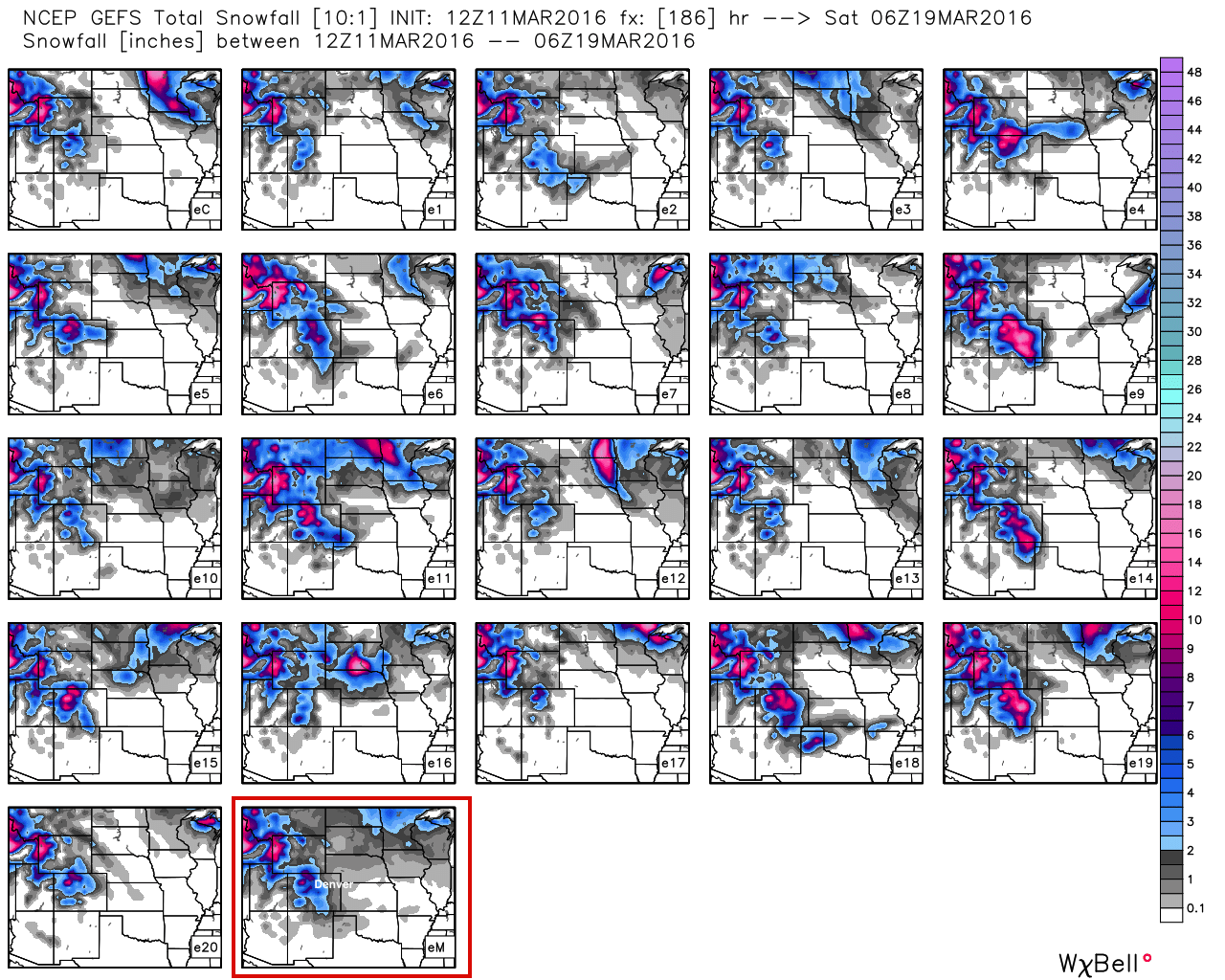
Of course, this is where the agreement ends. The GFS is (and has been) this least impressed, with the operational model showing very little meaningful snowfall at lower elevations, given warm surface temperatures, and little upper level support for heavier banded snowfall. The GFS ensemble at times has looked better, but today isn't all the impressive either. Below you can see each GEFS ensemble member's snowfall forecast through the end of next week, with the mean outlined in red at the end. A few members are pretty snowy, but look how many are snow-free east of the mountains...
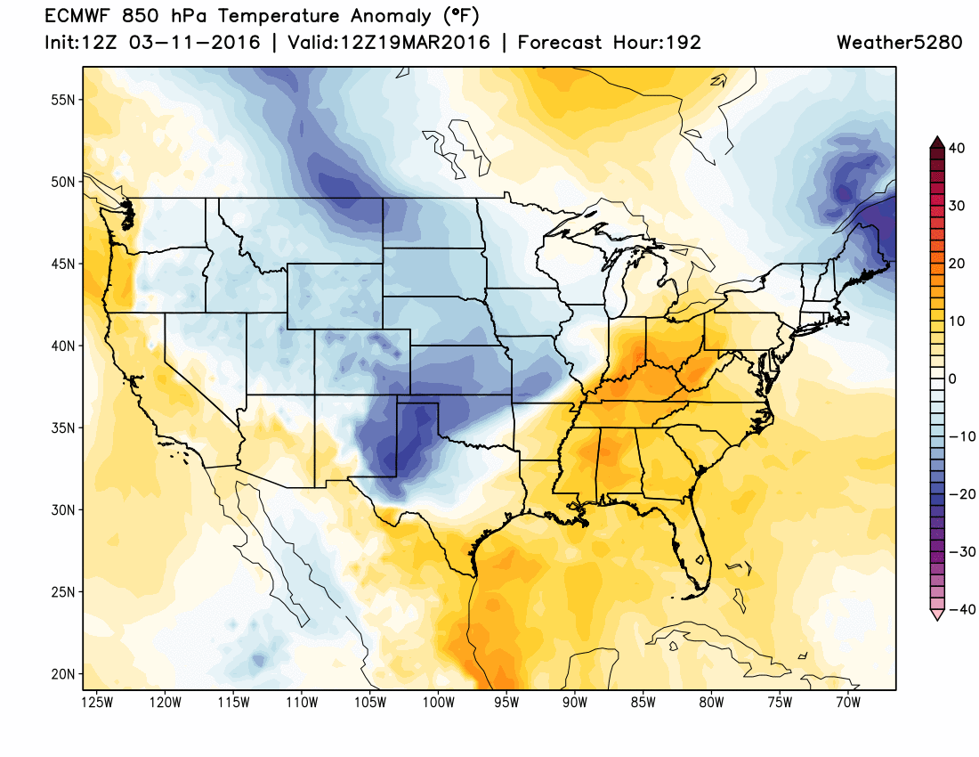
The EURO and Canadian models look better at the mid levels, and thus support a bit better snowfall across much of Colorado, and somewhere across the eastern Plains as well. At the moment I'm not really all that willing to bite, but that could be the 73.6° degree reading in my back yard right now speaking. The Canadian has been showing a heavy snowfall event for days now, but can be notoriously bad at medium range, and the EURO deterministic model thus far hasn't had a huge amount of support from its ensembles.
Whether it translates to snow for us in the Denver area next week or not, it certainly looks like some of the chilliest air we've seen in quite some time is on the way next week (after we cook this weekend), and at least an outside chance for some snow. For the time being, there's much greater confidence in the mountains seeing snowfall than for those of us across lower elevations to the east, but at least a few days of cooler temperatures is looking more likely.
I've long had mid March as the benchmark for when we can still have a high-impact snowfall event in Denver (hello 2003), even after a prolonged period of warm temperatures. By the second half of March and on into April, sure we can get big snowfalls (>12"), but typically by this late in the season ground temperatures and a high sun angle limit impacts, especially on paved surfaces. Often enough a few of snow will melt completely within a few short days. Does next week look like one of those high-impact March storms? No, not at the moment. Even under the Canadian scenario temperatures would likely go along way in reducing how much snow would actually be able to accumulate. That said, time to at least keep one eye on the forecast as to not be caught off guard next week as more seasonal weather returns, with at least a chance for some snow.
We'll have much more on these potential changes in Sunday's State of the Atmosphere. Is this the start of a more active period for Colorado? Possibly. GFS says no, others would suggest yes. Until then, enjoy the warm temperatures and sunshine, and be sure to subscribe to Weather5280 for all the latest!