Midweek Plains Snow Looks Increasingly Likely

While fire danger is high and temperatures are warm today, we're still tracking big changes to the weather as early as Tuesday night across eastern Colorado. While a fair amount of uncertainty about the details remains, confidence continues to grow that a strong winter storm will impact the region from Tuesday night and on into Thursday, bringing the chance for heavy snowfall, wind, and much colder temperatures to the plains of Colorado.
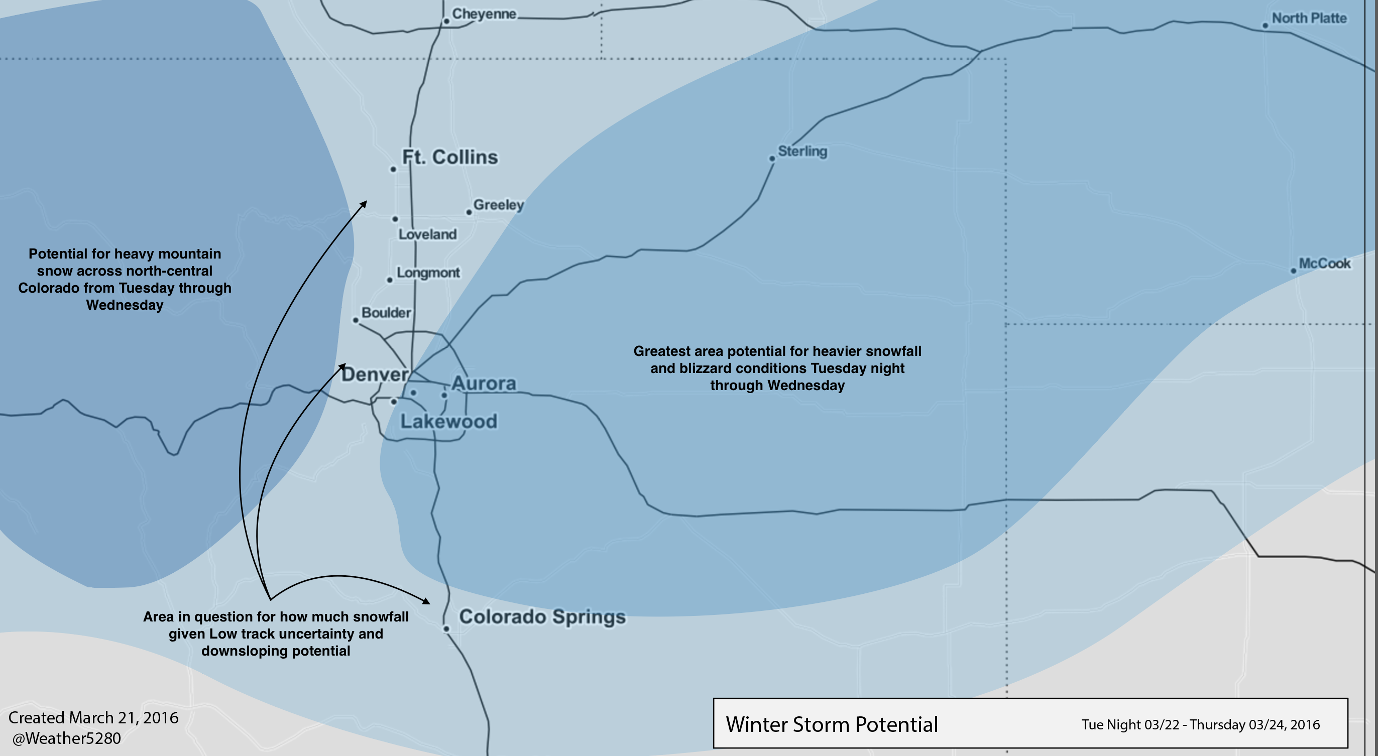
As we discussed in yesterday's State of the Atmosphere, we think the greatest threat for heavy snowfall may end up (generally) east of the urban corridor, with the likely storm track continuing to look slightly less favorable for areas west of I-25. This is due in large part to the potential for strong downsloping winds immediately along the foothills. This, however, wouldn't rule out snow completely for the Denver metro area, as we'll discuss below, and the forecast track of the Low may still change.
For now, we're thinking the greatest threat for heavy snowfall and strong winds extends from eastern/southeastern Denver, along and north of I-70:
For areas east of Denver the potential for blizzard conditions, Wednesday continues to look probable. The latest GFS shows winds from 20 to 40mph across the plains as the low intensifies east of Colorado. This in combination with snow will make for tough travel conditions along I-70 and I-76 Wednesday.
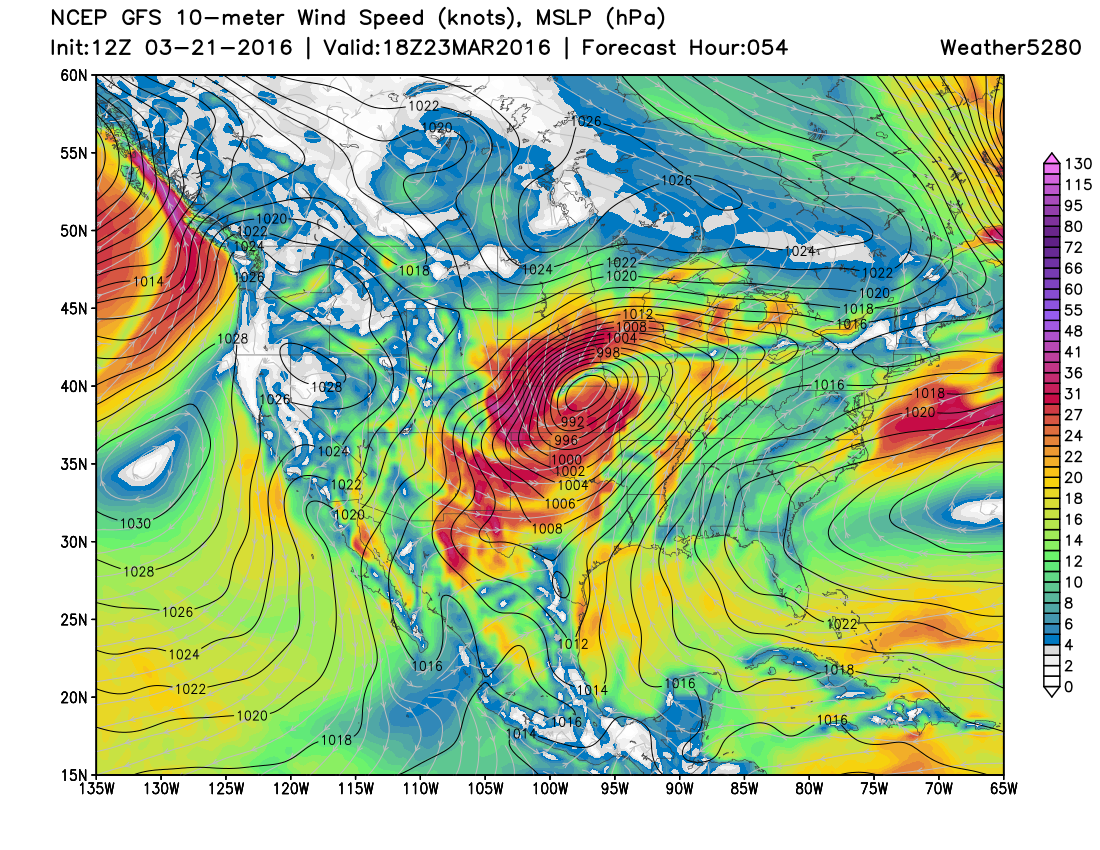
As for snow totals... still a bit early to say with a great deal of confidence given the uncertainties that remain. It looks like someone across northeast Colorado should manage 5 - 10" of snow with this system, but where exactly this ends up depends on the eventual track of our low. The EURO shows band after band of snow piling up decent totals from Denver due east, and while the more bullish of the models, we aren't ruling it out given its consistency in showing this for several days now. The NAM and GFS look slightly different where they place the heaviest QPF – the GFS immediately east of Denver (and including DIA, Aurora, etc), while the NAM centers the greatest snowfall across Washington, Yuma, and Kit Carson counties. Both the GFS and NAM are much stronger with downsloping immediately adjacent to the foothills (GFS has about 2" for Denver's western suburbs and >8" out near DIA), compared to the EURO. The EURO tracks the low a bit slower and further south, which helps increase Denver's snowfall chances late in the day Wednesday.
We'll go ahead and wait for more data before putting out official numbers... that'll either happen later this evening or early Tuesday. What's important for now is to prepare for the likely impacts, which include:
- Much colder temperatures are on the way beginning Tuesday night after two days of very mild conditions across the region. Highs Wednesday may reach 40 degrees, but will slowly fall during the day, with overnight lows Wednesday night in the low 20s.
- Heavy snow likely somewhere in eastern Colorado... the exact location for where the heaviest snowfall sets up remains a bit in question.
- Blizzard conditions likely at times across the eastern Plains, if you have travel plans east of the city from Tuesday night through Wednesday, please keep a close eye on the latest forecast.
- Even if the heaviest snow misses the greatest population core, this looks to be a good snowfall for much of northern Colorado, including the north-central mountains.
- Keep in mind that while some models look VERY convincing for heavy snow, much of this snow is forecast to fall during daytime hours with this system. Given how late we are in the year now... what FALLS vs what STICKS may be two different things this go around...
Lastly, it continues to look like there will be another system right on the heels of this storm due in for Friday and Saturday, which – again – may mean more accumulating snowfall for much of Colorado. Still a fair amount of uncertainty with this system as well, but it does look like it'll have some colder temperatures to work with, and will come right on the heels of this first snowfall, so could have an easier time sticking wherever it lines up.
We'll keep a close eye on things and issue an official snowfall forecast soon. Keep checking back, and of course, subscribe to Weather5280 if you haven't done so already.