The State of the Atmosphere: Sunday, April 10, 2016

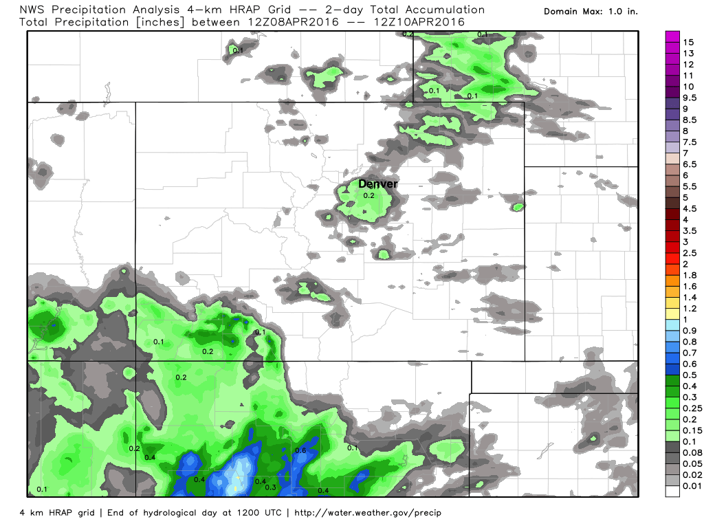
Another beautiful weekend ends, and it will do so this evening with some appreciated precipitation across the region. On Saturday, we saw some thunderstorms pop up in the evening, but they didn't produce too much in the way of rain. The cell over Denver had a few good rumbles of thunder and brought with it a quick tenth or two of moisture before quickly ending. Here are the rainfall totals from the last two days across Colorado:
More rain Sunday afternoon through Monday
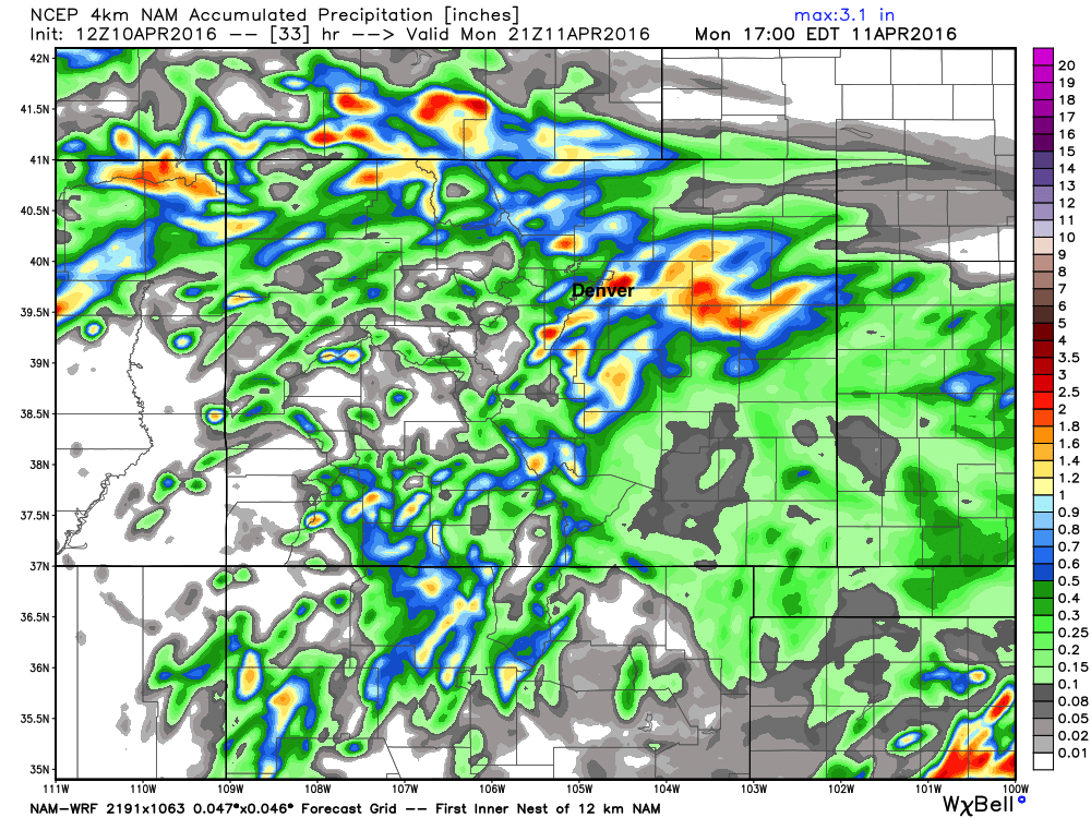
Precipitation totals overnight through Monday stand to be a bit more beneficial for a larger area. Models are producing anywhere from 0.2" to 1.5"+ of QPF for the greater Denver area from this afternoon through Monday – depending on where the bullseye of heaviest precipitation sets up. The Canadian has the heaviest rainfall across the city, while the GFS focuses the heavier precipitation south along the Palmer Divide, for example. Pinpointing exactly where the heaviest precipitation will fall will be difficult over the next 24 hours or so – so plan on cooler and unsettled weather, with the potential for some heavier bands of precipitation at times.
The latest hi-res 4km NAM shows these pockets of heavier precipitation we can expect over the next 24 hours or so, the exact location of these will shift, but helps show the potential:
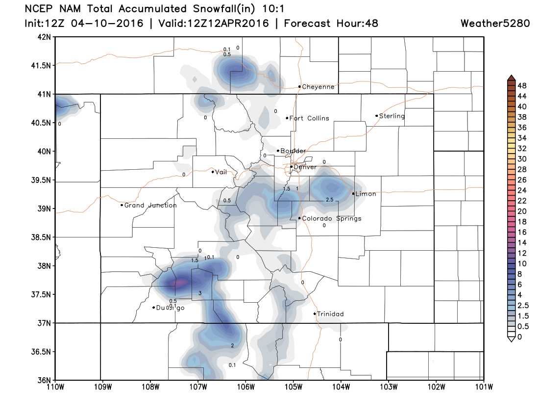
As for snow, we expect the greatest potential will remain above about 6,500 feet so most moisture should fall in the form of rain across the greater Denver area. That said, with enough cooling we could see snow levels drop a bit by early Monday, so don't be surprised if you see snow mixing in, or even a quick slushy inch or two under the heavier bands of precip.
The NAM appears most bullish for snow at this time, and even it isn't all that impressive – generally showing a coating to 3" across the Palmer Divide and extending east/northeast of Denver:
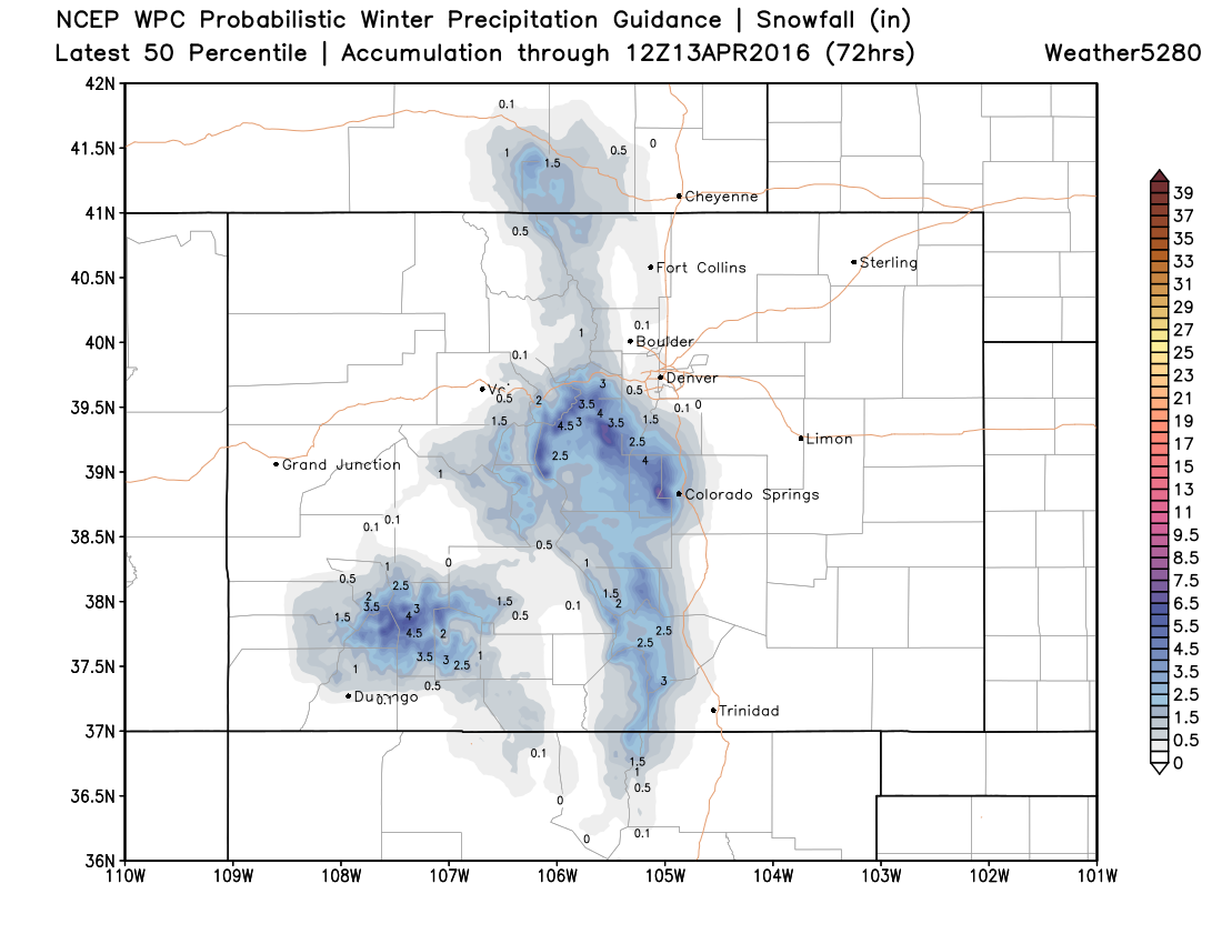
The WPC 50th percentile snowfall forecast (Shows you the 50/50 chance for the indicated snowfall amounts) for the next 72 hours shows the potential for a few inches of snow at higher elevations as well:
Plan on rain and snow showers to develop through Sunday afternoon, and the chance for rain and snow to continue into Monday across much of eastern Colorado. Monday's highs will be 5 to 10° cooler than Sunday's with the wet, unsettled weather lingering. Below is a look at the forecast radar for this afternoon through midnight, note the scattered showers and storms becoming more numerous across northeast Colorado through the evening:

The week ahead
By Tuesday, our temperatures will warm a bit once more as the main upper-level feature associated with the rain/snow tonight and Monday moves east. While highs will warm back into the 60s across northeast Colorado, the rain chances won't be completely gone. We may see a few afternoon thunderstorms develop, with pockets of moderate rain as well. Rainfall chances Tuesday will be lower, however, with generally a 20 to 30% chance of storms.
By Wednesday, the ridge reestablishes itself across the region, and with it, much warmer temperatures return as well. Latest MOS guidance has highs in the mid to upper 70s both Wednesday and Thursday across eastern Colorado, with no doubt the chances we see some low 80s in a few spots across the eastern Plains.
It's April, so we know this can't last. The midweek warmth looks to be relatively short-lived as our next upper-level system approaches from the west by late in the week and into next weekend. This next system looks to be packing a lot of water, and maybe even some cold air.
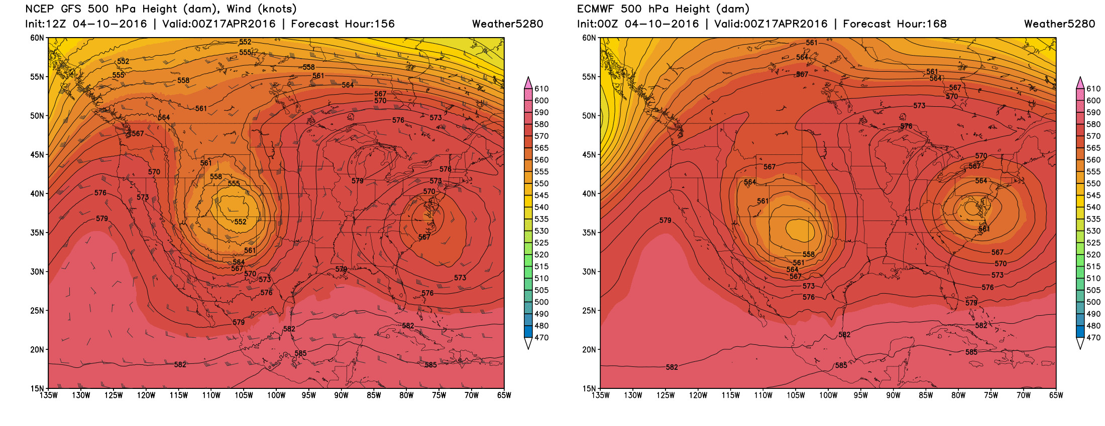
The million dollar question, of course, is what does that mean for our weather. The answer? It's too soon to tell. There's good agreement between global models now that a big trough will roll in from the west, but its track and how much cold air will be associated with it remain in big question. The Canadian and EURO came into decent agreement last night, both showing potential for a significant late-season winter storm across the region, while the GFS has generally been further north with the eventual track of the low. All three models produce some pretty hefty precipitation totals wherever the low ends up tracking.
Below is a look at the current forecasts from the GFS (left) and EURO (right) for the 500mb Low next weekend. As you can see, the center of the low on the EURO is much further south than the GFS, and would equate to a higher-impact event for our area, while the GFS would keep much of the heaviest precipitation north.
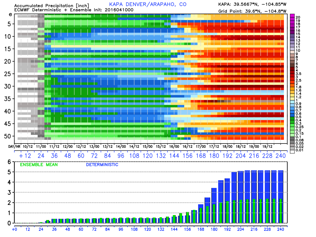
To help highlight the uncertainty, here's a look at the precipitation forecast for KAPA (Arapahoe county). The deterministic model is producing more than 5" (cumulative) of precipitation over the next 10 days while the ensemble mean is showing a bit less than half that amount of moisture. Obviously, the former would be a significant event while the latter would be hugely beneficial though more typical for an April storm. Of the 50 ensemble members, all look pretty wet next weekend:
In either case, definitely, one we need to watch. The good news is – it's a very long way out, so we'll have plenty of time to see how things progress over the next several days. For our part, we're hoping for a more southern solution, as we could REALLY use a good April drought-busting storm across southeast Colorado, north Texas, and western Kansas.