Monday PM Update: Tracking the Weekend Soaker

By now you've heard hype surrounding the incoming storm system that will arrive late this week and will last through the weekend into early next week.
This is days away, so let's not focus on specifics that can't be determined this far in advance and stick to things that we have observed in the modeling and look for a lasting trend to build a confident forecast from.
Storm track
The incoming storm system is projected to make a favorable path for giving lots of moisture to the region. This includes the Southwestern U.S., Colorado, Kansas, Oklahoma, Nebraska, Texas, and Wyoming. That's not to say that it's a slam dunk for heavy rain (or snow) for any given location within this region – that will depend on eventual details in the exact the track. The current forecast track is one that takes the center of the storm system from California through the Four Corners region:
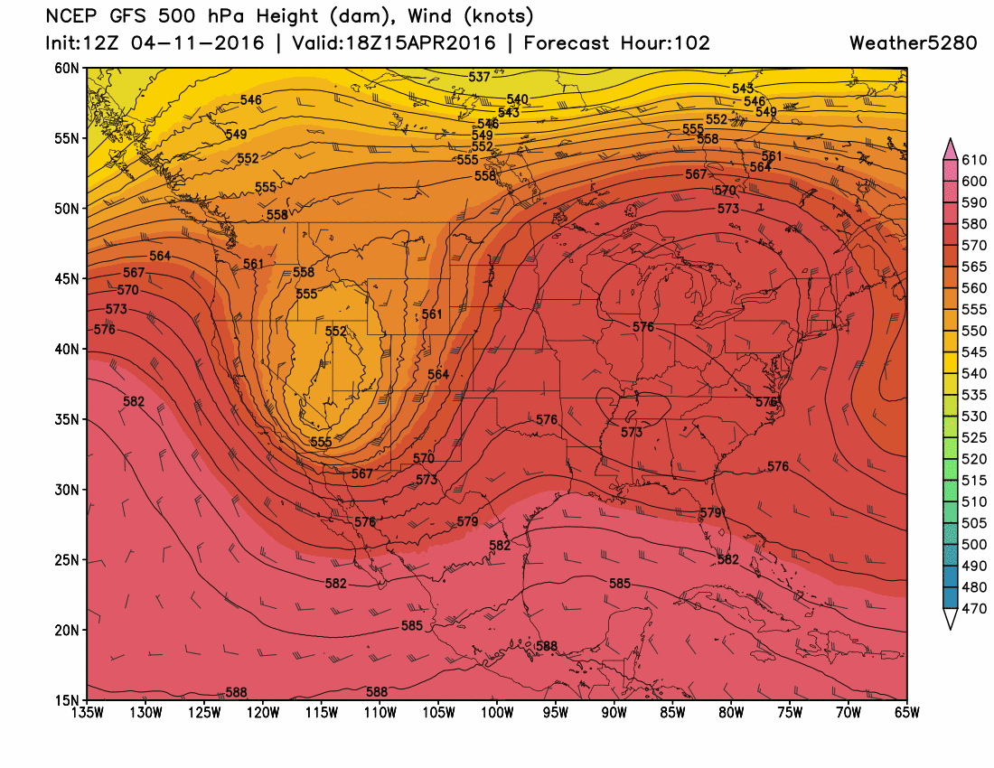
At this time, there are uncertainties on the exact track, i.e. southern Colorado or northern New Mexico.
Speed
The speed of the system is commonly projected to be a slow one along the described path above. Some models delay the center of the system over Arizona, which is possible from past experiences – and there is some reason to believe that this delay is quite possible; the reason is a cold Atlantic Ocean that will act to slow all storm systems over the U.S. until the ocean warms – meanwhile, another model projects the center to be a couple hundred miles east of the other model projections.
A couple hundred miles, or even a few dozen miles, can make all the difference in the world. It means differences in temperature which will affect the location of rain versus snow versus thunderstorms.
Temperatures
Again, the speed and track that the system ultimately takes will determine the amount of cold air that arrives. Due to the modeling difference in said speed and track there are also differences, 10 to 15-degree differences, in the temperatures that will arrive along the Front Range. This will impact how much rain falls versus snow. Some models, right now, are showing snow up and down the I-25 corridor and east across the Plains while others keep temperatures too warm at lower elevations for snow.
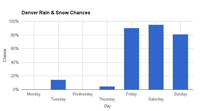
A soggy system
There is a consensus that this system will be very wet for many within the region. A couple to several inches of water will be possible along the Continental Divide to the plains and plains states to the east. The bullseye of the most water extends from Nebraska through Kansas to Oklahoma and Texas.
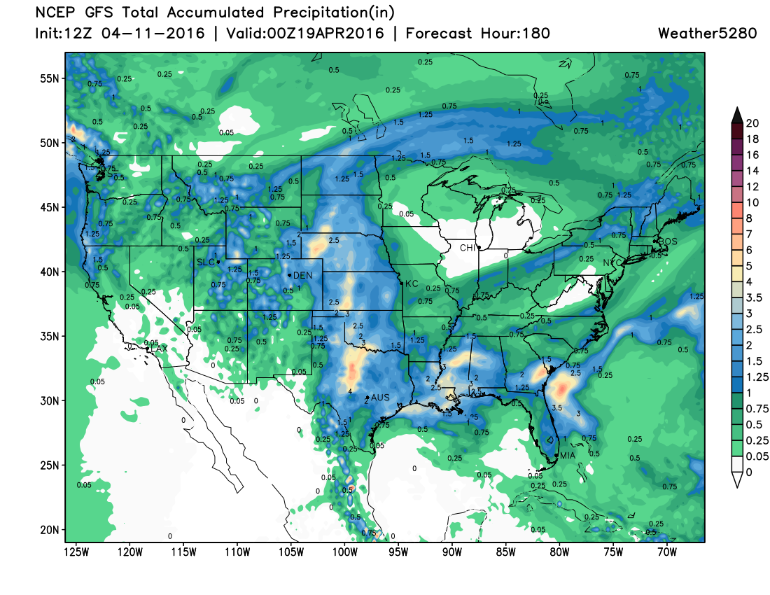
The amounts of water to fall are varied between some of the models. The lower end has only called for 1.0" for Denver up to 2.5" for the highest model. (Those numbers from Monday morning's modeling. At times models have been even higher with QPF).
Considerations
- Wet weather is very likely for the weekend. This will be in the form of rain and snow, likely, but awaiting a greater clarity of the temperatures that will end up here to determine where that snow elevation level will be.
- The speed and track of the system have plenty of time to change.
- The result of these things can lead to more, or less, intense thunderstorms from Nebraska through Kansas to Oklahoma and Texas. The intensity of these eastern thunderstorms may fool the model and bring less water to our area. Spring storm systems like this sometimes look wet, but "sponge-thunderstorms" that set up east of us can rob our area of a lot of moisture. The other side of the coin is if the storms aren't sponges, in which case we do indeed have a lot of water coming our way.
- Experience shows that these systems will bring someone a lot of snow if temperatures cool enough. The Palmer Divide (Douglas, El Paso, Elbert, and Lincoln Counties) is one such area that could receive the most precipitation. Another area would be the foothills and mountains between I-25 and the Divide. Strong wind is common with these systems, too.
Watching for...
While the evening and Tuesday morning models come in there remain a lot of questions to try to find answers to. Although too early for solid answers, we can, at least, look for trends. The trends we are looking for will be is the projected speed and path staying, relatively, the same. Also looking for the amount of projected precipitation staying in the same "ballpark". Temperatures will take some time to become clear and that does remain a critical factor in the entire evolution. That's why we will analyze the data and pass along the bullet points to you. Until the next time, fertilize your yards...this weekend may be a good one for soaking moisture.