Wednesday PM Update: Tracking Potential for Significant Spring Storm this Weekend

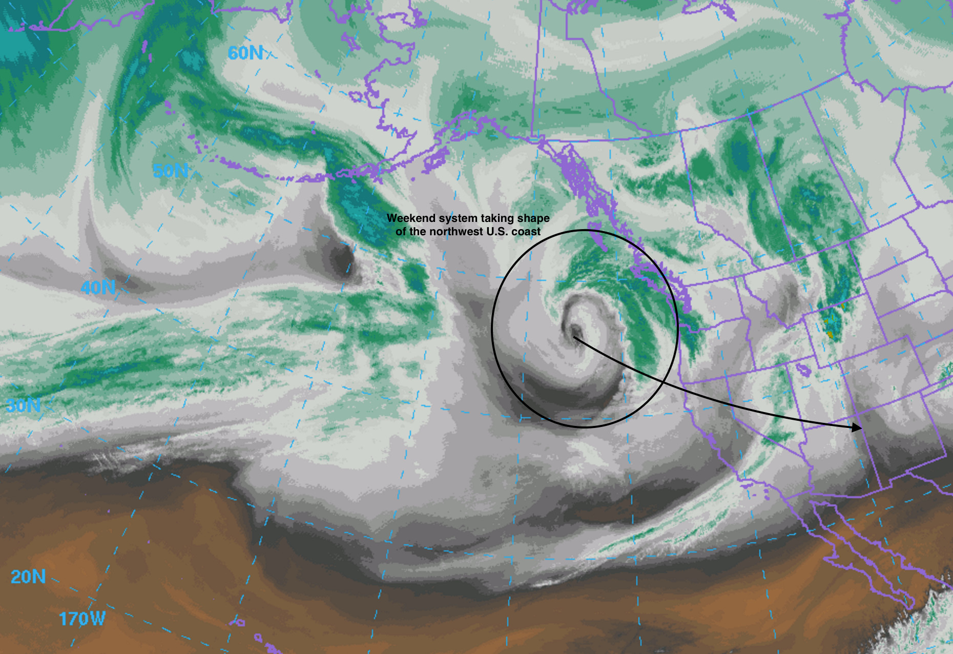
There's really not a whole lot of change in how things look today as compared to our update yesterday. The GFS (American model) continues to wobble with temperatures (currently showing little snow at lower elevations), and the EURO continues to hammer northeast Colorado with a big-time April snowstorm.
It's still too early to say exactly how things are going to line up for any given location, especially at lower elevations, say below 6,500 feet. While the potential for a heavy, high-impact snowfall remains on the table, questions regarding temperatures and the exact evolution of our storm system remain. In any event, someone in, if not all of, northeast Colorado will see a lot of precipitation from Friday night through Sunday night as a slow moving Low to the southwest brings ample moisture to the state. We also believe that the exact evolution of Friday's thunderstorms to the east of Denver will play a significant role in how much rain/snow will fall over the metro area.
Snow
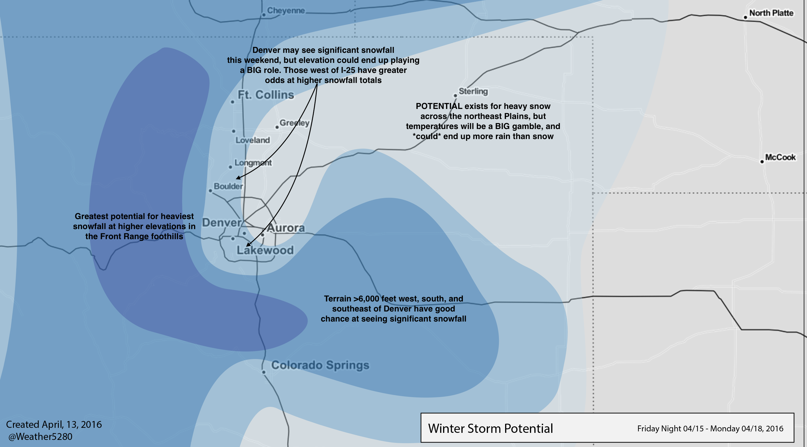
Below is a look at what we're currently thinking regarding the snowfall potential across northeast Colorado. Those at higher elevations west and southwest of Denver stand the best chance at seeing significant snowfall (i.e. more than a foot of snow) while those odds go down a bit as one heads east / northeast of Denver. As it stands, it looks like some locations in the Front Range foothills stand to do very well with this system.
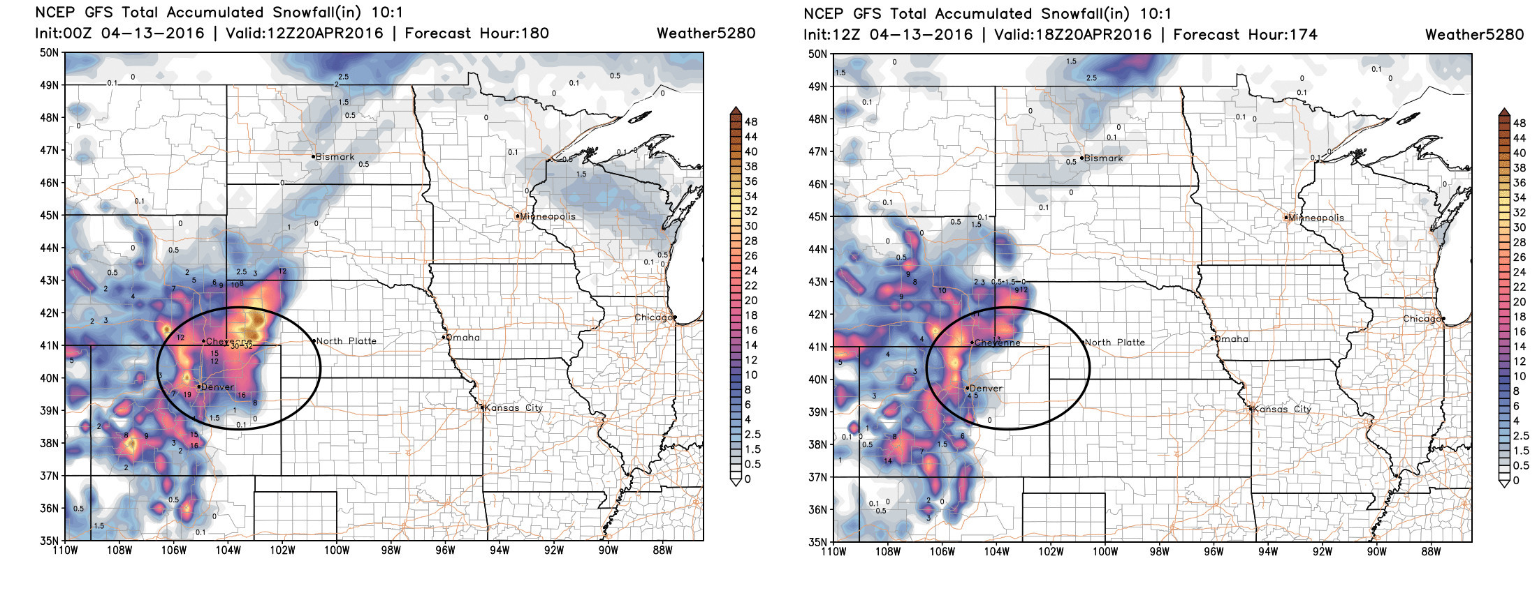
As for the models, they continue to have some disagreements regarding snowfall potential. The EURO has VERY consistently been producing heavy snowfall across the entirety of northeast Colorado (not to be ignored) while the GFS only first showed snowfall at lower elevations yesterday. If we look at the GFS snowfall forecast from last night (left) and compare that to today's early morning run (right) we see a big difference in how much snow it thinks will fall across the Plains. In both cases, it produces ample snowfall for the northern Front Range mountains (left side of black circle in both images). Given how late we are in the season, it's to be expected to see these run-to-run differences, as modeling how much cold air will filter in is very challenging given the extreme terrain variances across the region.
Moisture
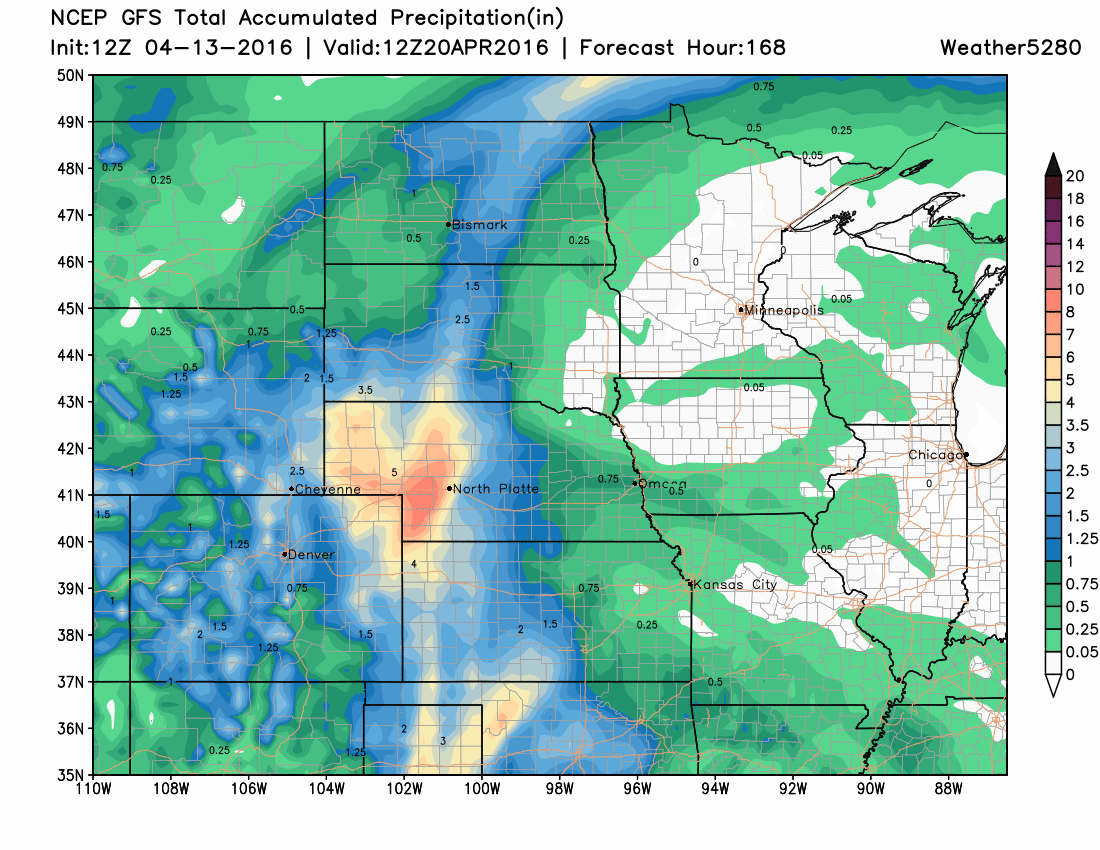
As for precipitation, whether that comes in the form of rain or snow (or both), this continues to look like a soggy storm for much of the region. Below is a look at the 12z (early morning) forecast run from the American GFS model for precipitation through the weekend. Currently, it has light precipitation from Colorado Springs south along I-25 with big-time precip focused across far eastern and northeast Colorado. The area of heaviest precip moves from run to run, as to be expected, but the fact that it continues to print out a 6" water total (this time in southwest Nebraska) speaks volumes to how much moisture this system will be carrying with it. For the Denver area, this run produces from 2 to 2.5" of liquid this weekend.
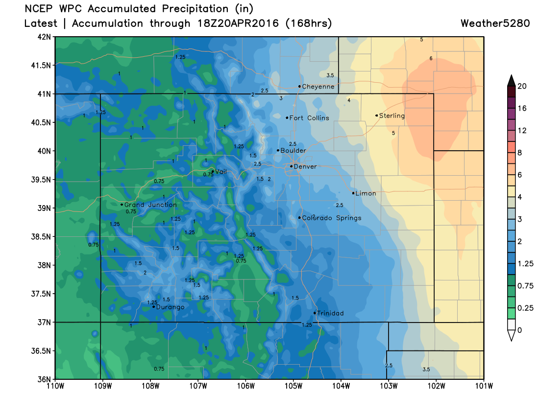
The latest WPC precipitation forecast looks a lot like the GFS, focusing the heaviest precipitation across extreme eastern Colorado, western Kansas, and western Nebraska. Nevertheless, they have totals from 1.5" to 2.5" up and down the I-25 corridor, and if much of this falls as snow, it will be significant.
Severe
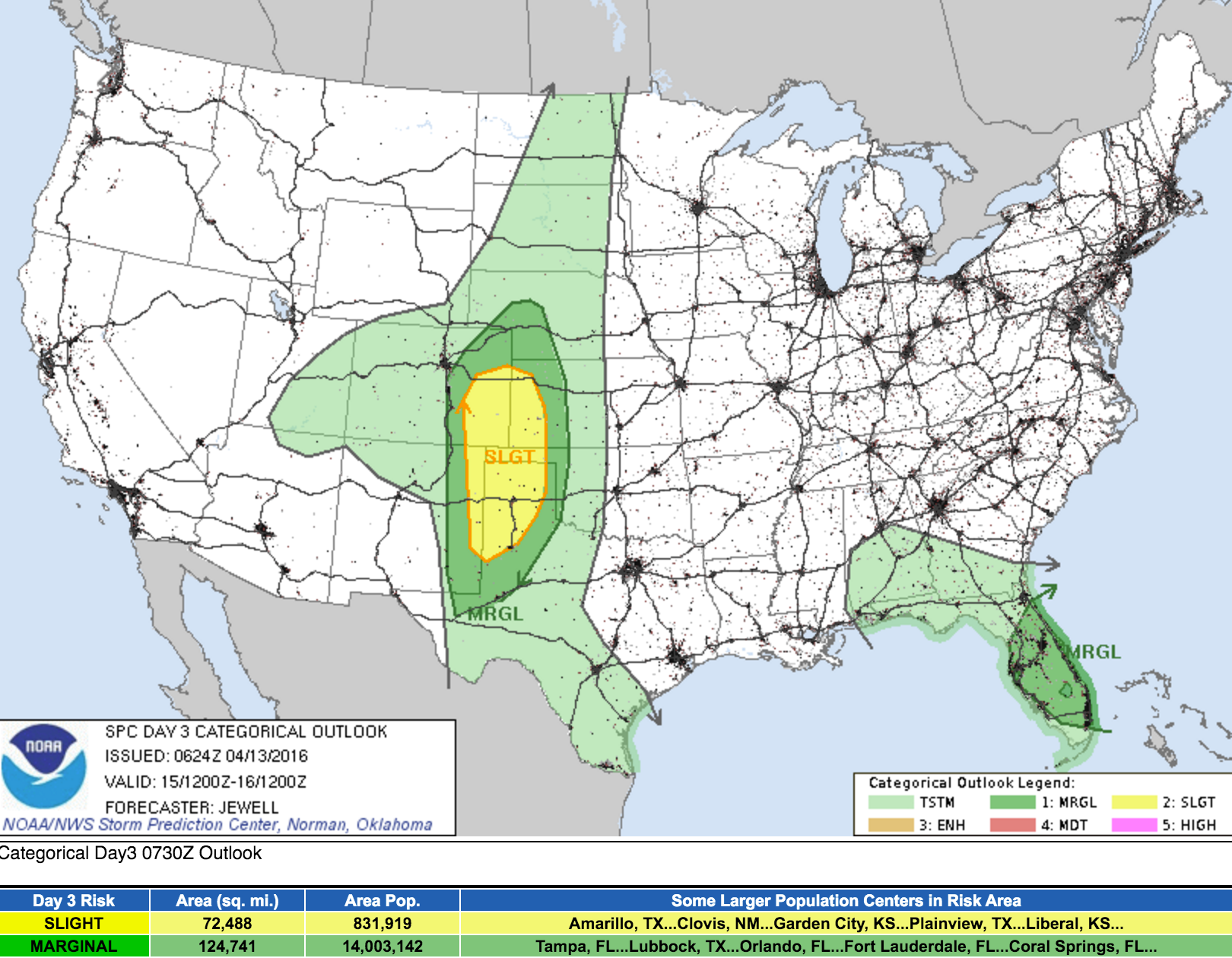
As discussed yesterday, severe weather still looks probable to kick things off on Friday, especially south and east of Denver. The latest SPC outlook for severe storms on Friday should look very similar to what we posted yesterday, with a marginal threat of severe storms across southeast Denver and the Palmer Ridge, and a slight risk for severe storms from Limon extending south and east (yellow). Storms here will be capable of producing large hail, damaging winds, and even tornadoes.
Good model agreement, devil is in the details
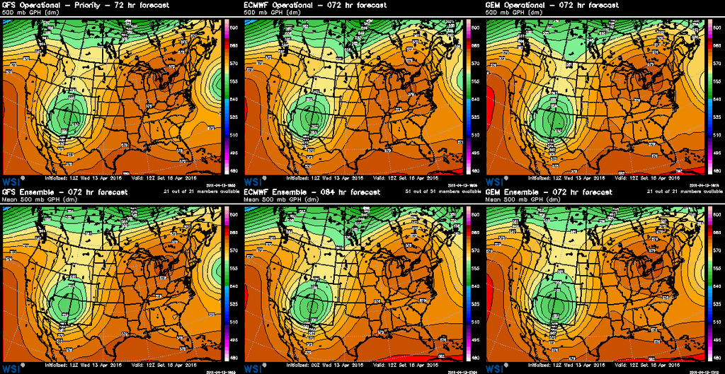
Overall, models are in pretty good agreement with this system. The biggest differences are in how much cold air each model brings to the table, where they focus the heaviest QPF (precipitation), and where/if they dry slot across eastern Colorado. If we look at the forecast low position for each of the three major global models we see pretty good consistency in placement. In the image below, note the placement and 'look' of each of the green blobs – all centered over northwest New Mexico (ish) at hour 84:
That's not to say we don't have any concerns. The first we addressed above, and that is with regard to temperatures and where that rain/snow line ends up. Another is the convection well east of Denver effectively acting as a sponge and robbing us of moisture – we've seen this many times with this spring storms.
With that, here are our TL;DR bullets:
- Changes arrive Friday, with severe storms possible across the eastern Plains, especially for southeast Colorado.
- The chance for rain and snow increases across the region Friday night. At this time, it appears to at least start as all rain at lower elevations, then possibly transition to snow by Saturday afternoon through Sunday.
- The Front Range mountains stand best odds as seeing significant snowfall with this event, more than 1 to 2 feet certainly possible.
- Snowfall potential for the greater Denver area still in question, but the potential for a damaging (think tree leaves) late-season snow is certainly on the table.
- The low will putz around southwest of Colorado through the weekend, and with that, our weather will stay chilly and wet at least into Sunday night.
It's shaping up to be a very busy several days! We hope you follow along with us at Weather5280, and subscribe for email updates if you haven't already. A new set of models are already running, so we'll see how things look by tonight!