Winter Storm Warning Goes into Effect Early Saturday; A Few Changes to Snowfall Forecast And Latest Discussion

Saturday, April 16, 10:00am: For latest snowfall totals and other resources associated with this ongoing spring storm, please visit our Spring Storm Reports and Resources page.
Previous discussion...
We knew that this system would remain a challenge right up to the end, and with that hopefully we've done a good job stressing the uncertainty around this event all week. Forecasting a mid-April snow, with a very slow-moving 500mb cutoff low (storm system detached from main storm flow), is not exactly a cake walk across northeast Colorado. The wind, terrain, and ultimately moisture availability play HUGE roles in who sees what when it comes to heavy rain, heavy snow, both, or not much of anything over very short distances.
Model deep-dive and uncertainties
As we head into the final hours before the rain and snow begin across the region, the models are STILL struggling with how much of this weekend's precipitation falls as snow at lower elevations.
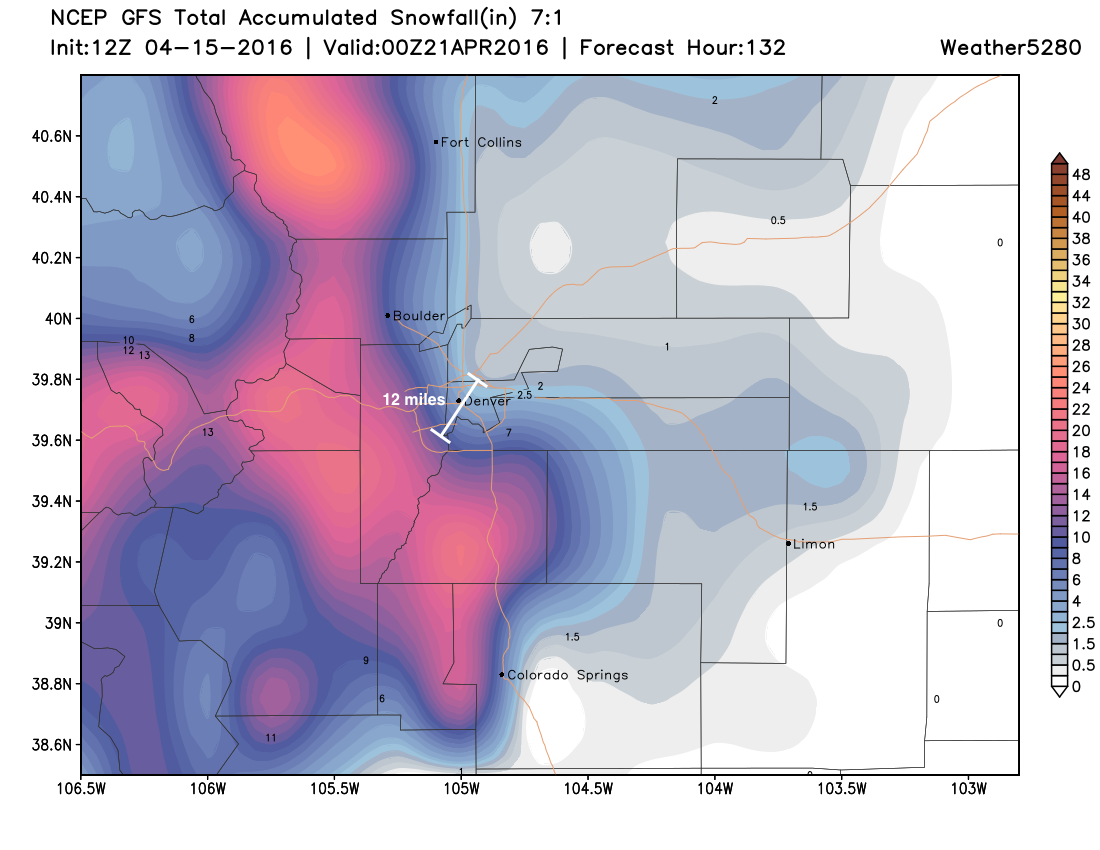
Take a look at today's early morning GFS snowfall forecast (below), for example. We've made a custom plot showing 7:1 snowfall ratios, meaning 7" of snow to 1" of liquid, which is much lower than the typical 17:1 we see in the area during the winter months. It shows a VERY sharp gradient from a significant snowfall on the west/southwest side of town, to a non-event (snow-wise) on the northeast side of town. Over a range of just 12 miles, and the entire City and County of Denver, totals range from 8 - 12" southwest, to 1 - 2" northeast. Needless to say, under this scenario, this certainly won't be an equal opportunity snowfall for everyone in the metro area.
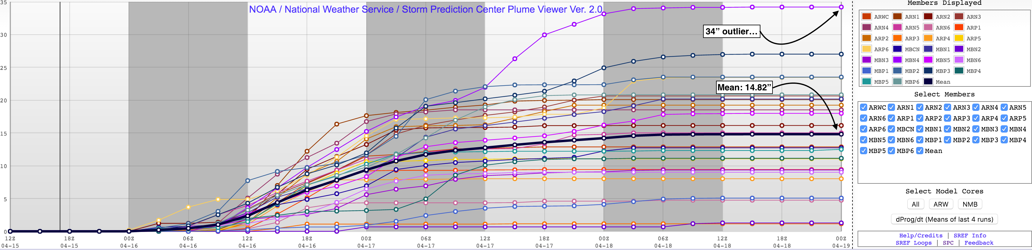
Another way to reiterate the amount of uncertainty with this snowfall forecast is to look at various ensemble forecasts and each "member's" individual forecast. Take the short-term forecast SREF. It's often one of the more bullish forecast models and is so again today. That said, the ensemble spread is crazy – with one member printing off nearly 35" of snow for Denver (DIA), and another just 1.28" of snow! That puts the mean at 14.82", but with very little clustering around that average...
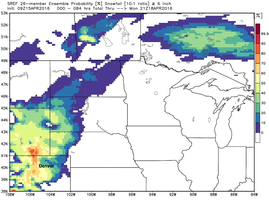
SREF probabilities are maybe of a bit more use in these case, and show decent odds still of >6" of snow across the region – again, with those odds greatest west of I-25, and south/southwest/southeast of Denver (yellows and reds):
In more general terms, forecast models have generally reduced snowfall this morning, after many looked a bit snowier than previous runs last night. There are a number of reasons for this... some models are showing a short duration event (less snow on Sunday) while others are either warmer or have cut total precipitation a bit.
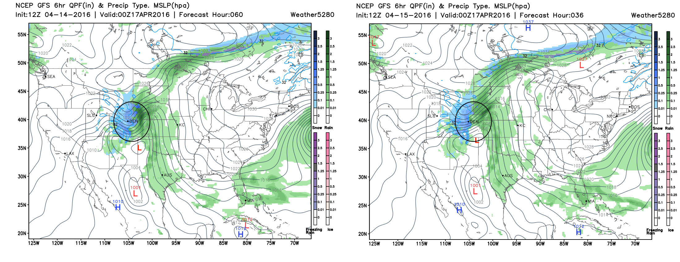
If we again pick on the GFS (American model), take a look at yesterday's forecast for Saturday evening (left), compared to today's forecast for Saturday evening (right). In yesterday's runs, we see the surface low is further south (red L southeast of Colorado) while today it's further north. Also, note the buckle in the black lines (in the black circle) over Colorado yesterday were more exaggerated, which signified more cold air filtering down the I-25 urban corridor than we are seeing int today's run. A hiccup? Or a trend. It's hard to say, but under today's scenario, one would expect much less snowfall at lower elevations. As is so often the case, the difference in placement of the low is SO crucial, and the difference of just one or two hundred miles means big impacts on snowfall potential around here, as we've seen several times this year already.
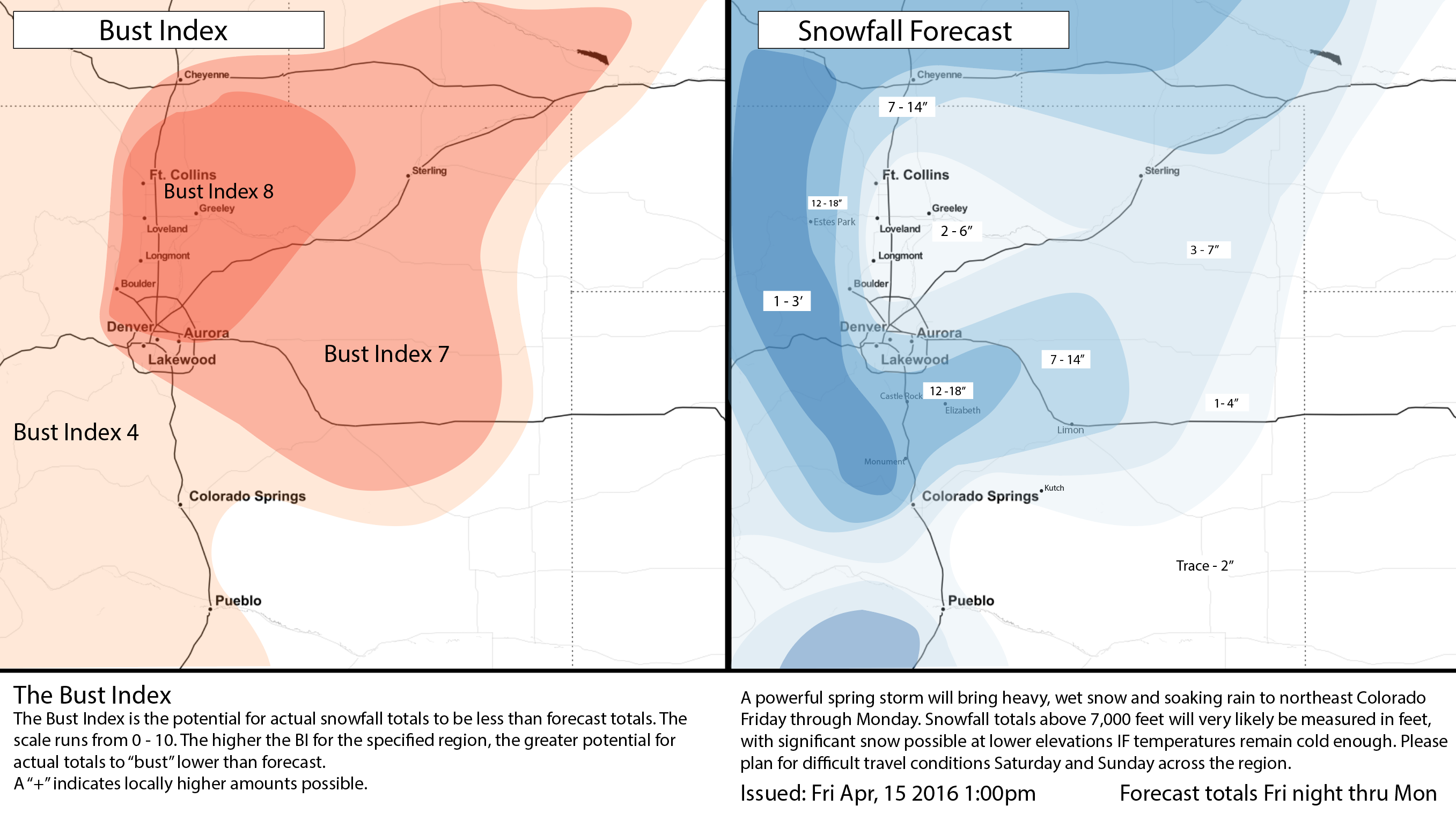
This jog north in the GFS is concerning, for any forecast. It's a very similar look to a similar system last year, that ended up not doing much as the GFS in the last minute jogged the low north, and ended up correct. THAT SAID, the 12z EURO has come in and is sticking strongly to previous solutions. So, while we'll lower totals a bit (see below) we'll still hedge a bit higher than GFS. Also, given we do think cold air will filter in faster than many models indicate, we'll still weight our forecast toward the higher end, but will have to keep the Bust Index pretty high at lower elevations (Bust index is our confidence rating that the forecast will pan out to be higher than the actual amount of snowfall). Basically, the more rain you see at your house, likely the less snow you'll see. The difference of a degree or two in temperature tomorrow will have big impacts on our snowfall forecast.
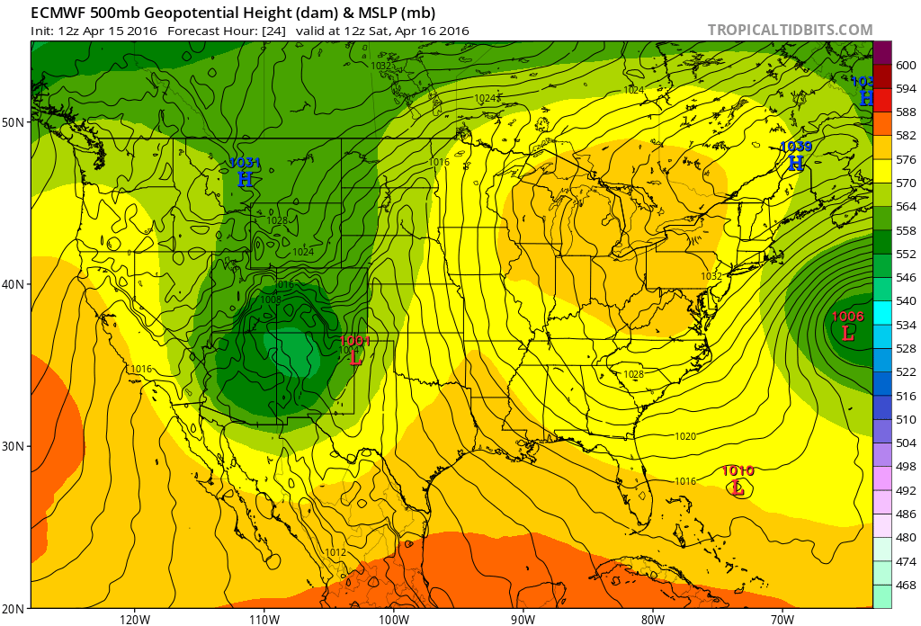
The ECMWF remains a bit further south (ala yesterday's 12z GFS) with the low today:
Takeaways and updated snowfall forecast
So, the takeaway from this morning is, we'll go ahead and lower snowfall forecast totals a bit, but hedge on the high-side given the EURO. Elevation and temperatures will play a HUGE role in how much snow you see at your particular location. The difference of a degree or two in temperature likely means the difference of mostly rain/a bit of slush or several heavy inches of snow Saturday and Saturday night.
We'll go 7 - 14" from central Denver south (higher totals south) with 3 - 7" on the north side. It's important to remember, that melting and compaction can and likely will limit totals, so at any given time totals you see here may be on the low side. For the Palmer Ridge south of Denver, we still think 12"+ will be possible, with 1 - 3 feet for the Front Range mountains. The Bust Index remains HIGH at lower elevations:
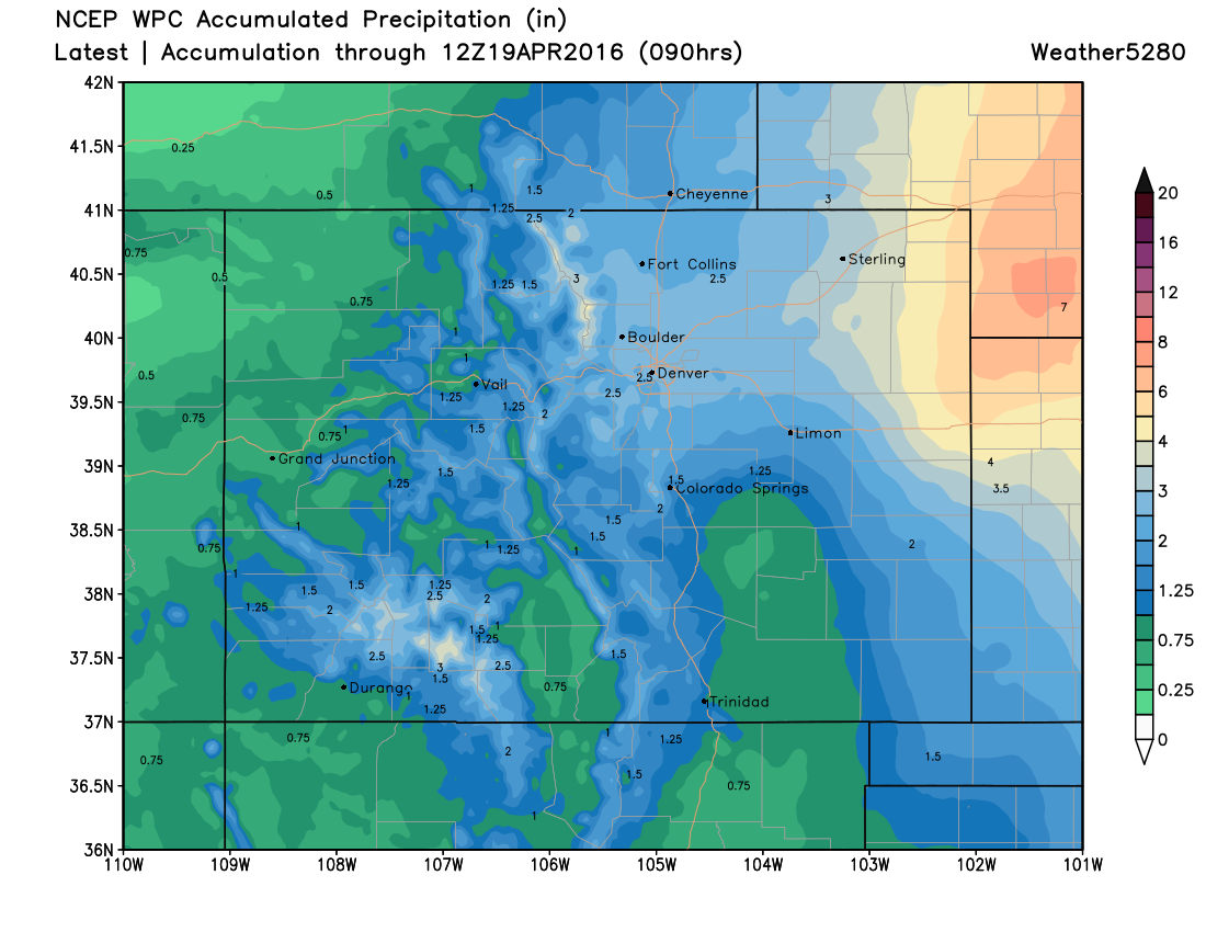
Big snow or not, the forecast continues to look decidedly wet across the region. Below is the latest WPC precipitation forecast through the weekend, with 1 - 3" across the greater Denver area, with pockets of 3"+ for the Front Range mountains, and >4" possible across the far eastern Plains. Where heavier precipitation does set up, flooding will certainly be a concern.
TL;DR
We know this was a long update, but there's been a lot of interest in this system, so we thought we'd take some time to explain a lot of what we've been looking at over the last 24 hours or so. In the end – we still expect a soggy weekend across northeast Colorado, and if temperatures cooperate, much of that will fall as snow, especially along and west of I-25, and south across the Palmer Ridge. A colder solution would mean more of that heavier snow extends east into the Plains while a warmer one would mean more rain than snow at lower elevations. So, in short:
- Wet and chilly weekend ahead.
- High uncertainty around snowfall at lower elevations, but potential for heavy snow
- Even a few inches of slushy snow will be very hard on area trees that have leafed. If you can, try and keep the snow cleared off of them. Expect potential for power outages should heavy snow build up on trees and break branches.
- Travel will be difficult, especially headed west and south of Denver, but even east across the Plains with either heavy snow, OR heavy rain making travel difficult along I-70 and I-76 Saturday and Sunday.
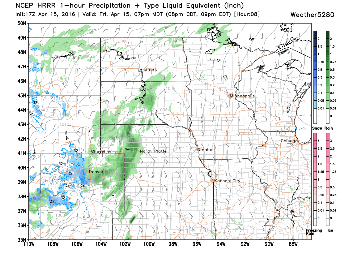
- Latest HRRR shows rain at lower elevations and snow at higher elevations becoming more widespread by this evening... so here it comes, and we'll see what happens!
Subscribe to Weather5820 and keep in touch this weekend in the comments below! We'd love to hear your storm reports whether rain, snow, or shine!