A Return of the Monsoon for August? La Niña Check, Winter Analogs, and That Pesky PDO

In a good year, August can be one of the wetter months of the year for many of us in Colorado. Right on schedule, we've had a recent surge of monsoon moisture. This is always a good thing, especially when the amount of flash flooding we've seen of late has been relatively low.
Below is a look at rainfall totals for the past three weeks. Overall, a pretty good look for the state. Northwest Colorado is hurting the most, with those of us living along the northern I-25 urban corridor also missing out on recent rains (see the last four days):
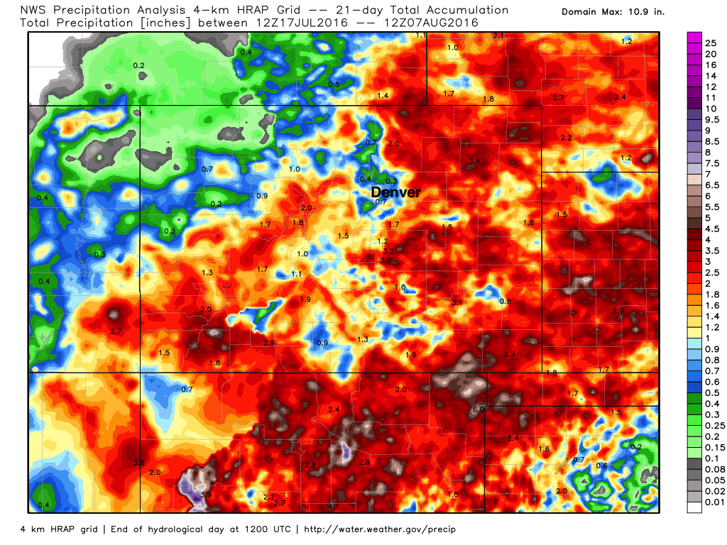
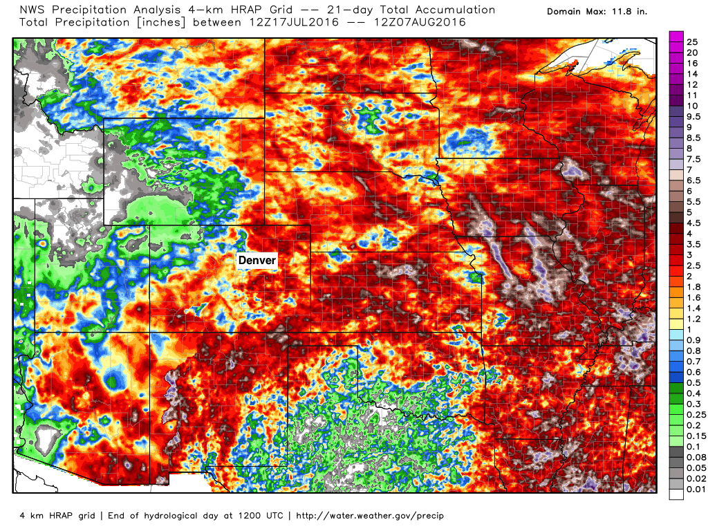
You can see that folks in MOST of Eastern Colorado have been getting rain, despite the dry spots from Denver north. We've also see regional rains... check out New Mexico, Arizona, Nebraska, and Kansas:
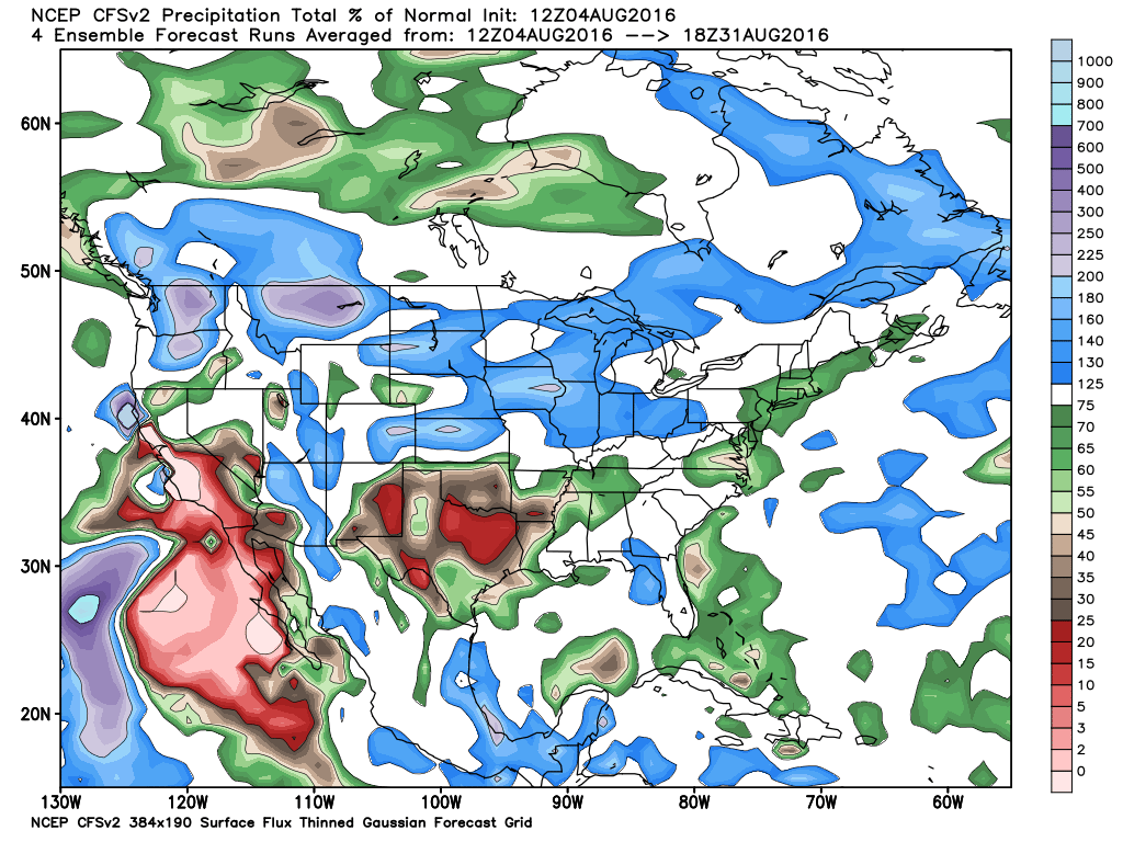
As of right now, it looks like at least the next month (possibly) longer will remain relatively active for Colorado. Many different models have been hinting at this for a while, and the CFSv2 (which I rarely like to show) is one such model.
**CFSv2 Model Precipitation Forecast Through August 31st **
**CFSv2 Model Precipitation Forecast September 1st-18th **
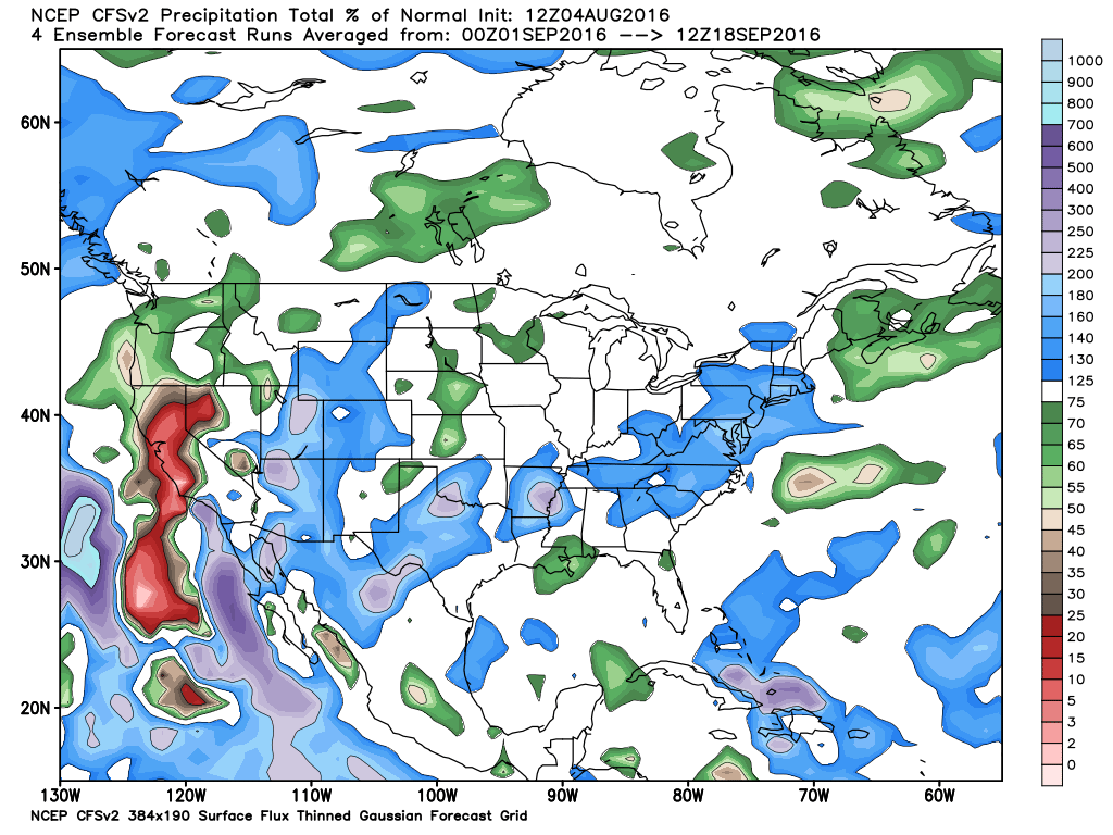
Notice that most of Colorado is shaded in blue through mid September, meaning the chance of getting above average moisture looks pretty good, according to this model. Which, brings me back to a question that you may be asking: why are you showing me the CFSv2 Model, when you usually don't like it in the long range? Because it has actually been fairing better than it usually does. Given that we are not in El Niño or La Niña right now, this might actually be helping the model generate a better forecast.
The two things I have noticed lately that stick out to me is that it has nailed a dry Texas and a wet Iowa. If it can get the ridge placement right over Texas, then it will likely get the storm track placement correct over the Midwest. So far, that has been the case... And, we are seeing our monsoon ramp up accordingly, on the northern edge of the ridge. To make a long story longer, my confidence is higher with this model than usual.
So, this obviously raises some concern about flash flood potential going forward. It should, as the monsoon tap seems poised to be impacting us for a while and possibly a bit longer than usual. We'll see.
What about La Niña?
Well, she isn't coming on strongly yet. Does that mean it isn't going to happen? No, not yet. Remember, we are in the wet season and the ENSO cycle usually doesn't like to show us its cards until after August. While we can have a good idea what it will do, the specifics are always harder this time of year.
Current Sea Surface Temperatures Anomalies
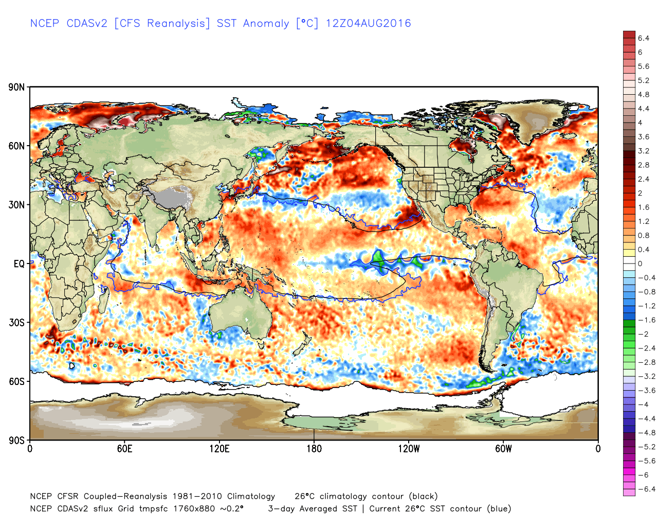
Right now, the current Oceanic Niño Index is at 0.2. This classifies us as "neutral" despite the colder than normal water off the west coast of South America. The whole Pacific Basin is "more warm" than not, and this kept the June Pacific Decadal Oscillation Index at 2.03. The Atlantic Basin is also warm, keeping the Atlantic Multidecadal Oscillation Index 0.423 for June. That means that as of right now, we are dealing with neutral ENSO conditions, a very positive/warm PDO, and a warm/positive AMO.
ENSO Model Ensemble
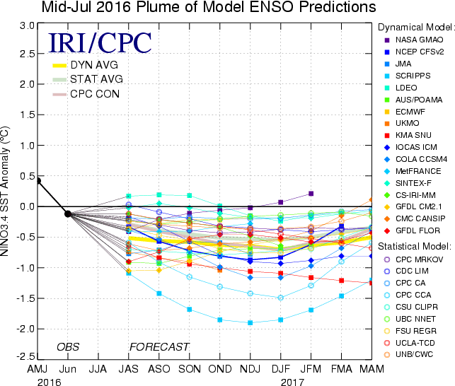
Now, compare the Mid-July ENSO Plumes with those that were forecast in May:
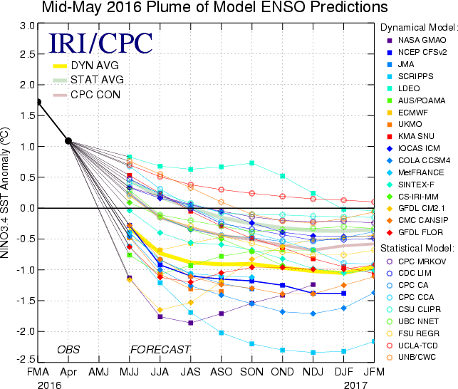
The May plumes had us in solid La Niña territory by late summer, with the signal likely to strengthen a bit in the winter. So why the change? I believe the ENSO models may be struggling a bit during the wet season. But, I also believe that the models recognize that we will likely have a very positive/warm PDO for the next several months. Stronger and longer lasting La Niña episodes are often rare when the PDO is this positive/warm. As I lamented above, I believe we will have a better idea where we are headed in about a month. So while I am not cancelling the La Niña, I do not think it will be a strong or long lasting event. In fact, I could see our ENSO phase staying pretty neutral or just a bit colder than neutral for the next several months.
Analog comments
I have been looking for analog years to use for an upcoming long range forecast. Given our current conditions, it is has been a very hard task. However, I have come up with a few possibilities: 1942-43, 1959-60, and possibly 1995-96.
Now, 1942-43 offered up a moderate La Niña, 1995-96 a weak La Niña, and 1959-60 kept us ENSO neutral. As of right now, my analogs and subsequent winter snowfall totals would go in this favored order:
- 1959-60 (80.6" total snowfall)
- 1995-96 (50.3" total snowfall)
- 1942-43 (36.3" total snowfall)
However, I am still looking for additional years with similar current conditions that followed up a strong El Niño. But like I said, that has been a very tough task and may indicate poor analogs going into the seasonal change. One interesting point about the 1959-60 winter...September/October snowfall total was 24.7" for Denver. In fact, Colorado Springs totaled an amazing 27.9" of snow that September alone! Winter definitely came early that year. Are we due?
Given what I have told you above, one can also come up with some pretty good common sense projections.
- We rarely struggle with moisture when the PDO is positive/warm
- We are rarely colder than average when the PDO is positive/warm
- When the PDO is positive/warm, we usually see our best snow during the back half of the winter and into spring.
Does this mean we will see all of that happen this year? No, but it does provide a general road map about where we may be headed.