Initial Snowfall Forecast as State Braces for Cold

We've had several updates this week on here and on Facebook discussing the big changes on the way late in the day Friday and for the weekend. Today we'll have warm and wind to contend with, especially across southeast Colorado where are Red Flag Warning is in effect due to high winds, low humidities, and temperatures likely nearing record high territory.
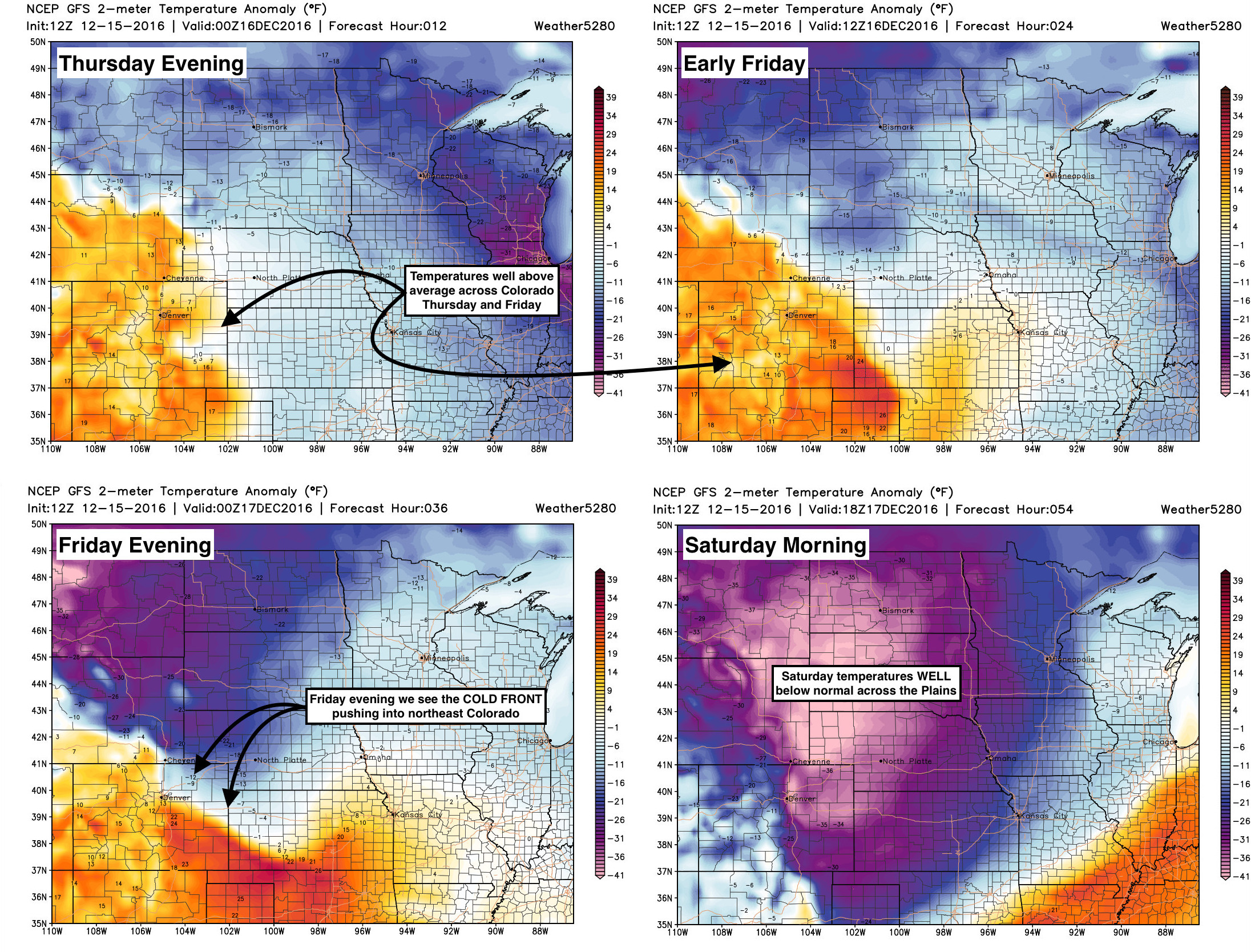
By Friday we start to see changes arrive. Depending on the speed of the front, we may very well climb back into the 50s across the Denver area – though if it moves in a bit faster than forecast, 40s may be all we can manage. By Friday evening at the latest we see the initial push of cold air moving into northeast Colorado, with a sharp front sliding across eastern Colorado. The maps below are of temperature anomaly forecasts, or temperatures as compared to average. As you can see in the top two maps, there's lots of red across Colorado. This signifies temperatures well above average today and Friday, with highs in the 50s and 60s across the Plains. By Friday evening, however, you see the blues and purples invade... with temperatures 30 to 40 degrees below normal by Saturday morning, with highs only in the SINGLE digits for Denver on Saturday:
Latest MOS guidance has highs near 50 degrees on Friday in Denver, but the overnight low dropping below zero by early Saturday. That'll be quite a change. The GEFS has a low of -4° Saturday morning, which factoring in the wind chill would feel morel like -15 to -20° F.
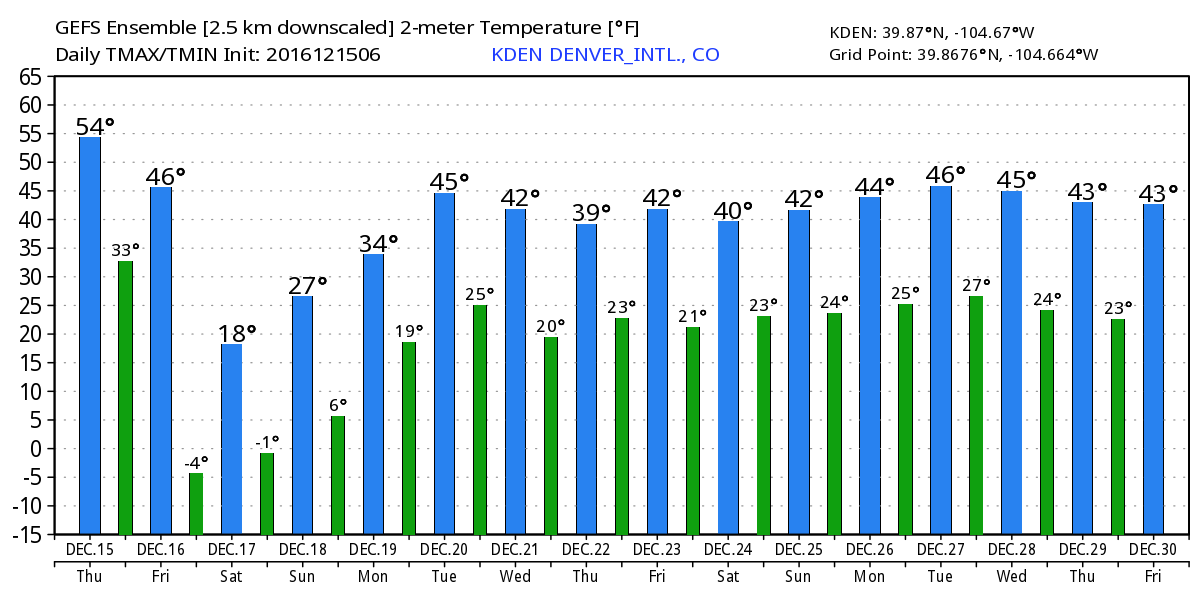
The good news is, the arctic air doesn't linger long. Saturday night and Sunday will remain VERY chilly across the state, but we'll warm back into the 30s and 40s to start the week, with overnight lows in the 20s.
The snow
Much like our last system, for many locales the bigger story will be the cold than the snow with this next system. That said, it looks likely that most folks across eastern Colorado see some snow with this event, with a few areas under banded snowfall picking up several inches.
And herein lies the key to the forecast. There won't be much of an upslope component to this system, so we'll be relying on the front to provide our lift for snow, in addition to jet dynamics. This jet induced snowfall will lead to areas of heavier snow where more persistent snow bands are able to develop. With that, these types of setups really lead to the haves and have nots... if you end up under a band you'll do pretty well, while right down the road may only end up with a dusting to an inch.
Related: Snowfall probability charts for select Front Range cities
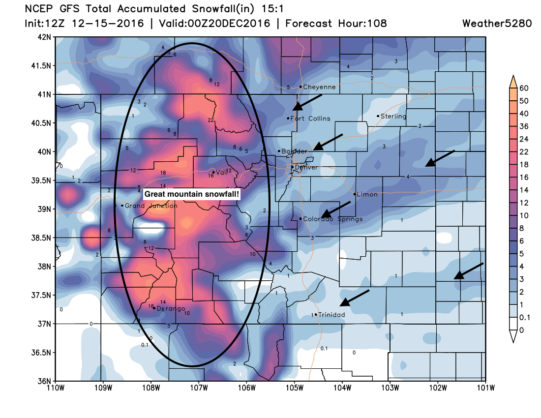
The GFS has been doing a great job trying to pick up on this. Without taking too literally (please!) take note of a few things in the image below. First, this will be another great snowfall event for the mountains which is great news. If you look out across the plains, you see these streaks of heavier snowfall, with much lighter totals in between. While we think the idea is right, it's hard to say exactly where those heavier bands will set up, and models are notoriously bad at trying to forecast them. That said, we very often see one set up north of Denver (as shown) and it's been pretty insistent about the one over Colorado Springs extending east/northeast. So, maybe not too bad a forecast.
In short, if the band sets up too far north of Denver the city maybe sees an inch of snow, if it sets up further south, we could be looking at more like 3 to 5" of snow. Tough call.
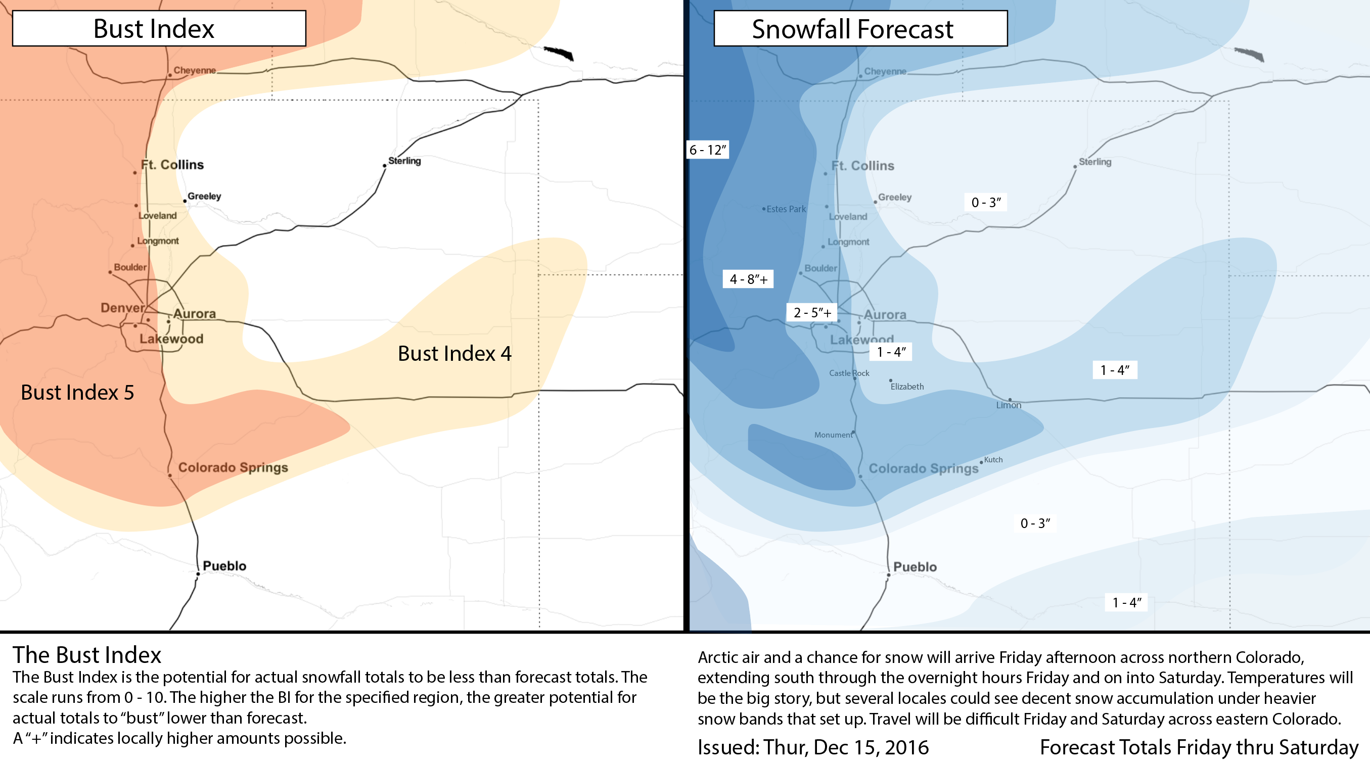
With all that considered... here's our initial snowfall forecast. Generally going 2 - 5" along and west of I-25, with 1 - 4" east of I-25. Again, there will likely be a big range in totals from this event, but a few folks may do very well with snow with this system.
Timing
- Friday highs in the 40s and 50s across eastern Colorado. By afternoon likely seeing cold air starting to spill into northern Colorado.
- Friday evening that front is making its way toward Denver, perhaps a bit earlier if it's moving faster than currently forecast.
- Snow will begin north along the Wyoming/Colorado state line Friday afternoon, then slowly move south with the front through the evening and overnight hours.
- Denver's best window for snow comes later Friday evening through Saturday morning. Again, we're looking at 2 - 5" west of I-25, with about 1 - 4" east, with higher totals possible under bands. Important to remember, that even if low-end snowfall totals, any snow combined with the bitter cold air, will make travel treacherous for a time across eastern Colorado from Friday night through Saturday.
- We stay chilly, but dry things out for Sunday.