
Friday PM Update: Coldest Air Yet to Arrive; Snow Chances Increase This Evening

Friday 9pm Storm Update: Storm on track, latest video update on our Facebook page here.
Arctic chill
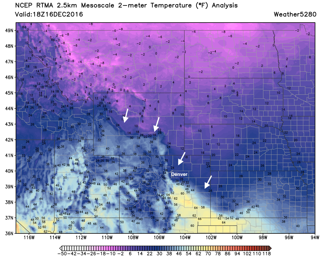
The well-advertised cold air began pushing into northeast Colorado early Friday. In Denver we saw early morning highs in the mid 40s, but now temperatures are sitting in the mid to upper 20s, and will continue to fall as the afternoon progresses. A look at the latest analysis map below shows quite clearly where the coldest air is now situated (at the ends of the white arrows). Remarkably, while Denver is in the 20s at this hour, those living in Colorado Springs are enjoying midday highs near 60°!
The front has seemingly stalled a little right now, but will eventually push south into the evening hours. Expect temperatures in Denver to hover more or less where they are for a few hours, before the true cold arrives.
Here's a look at the latest high-resolution HRRR forecast for 2 meter temperatures. Note how warm it is across southeast Colorado... that'll change by midnight, where this loop ends:
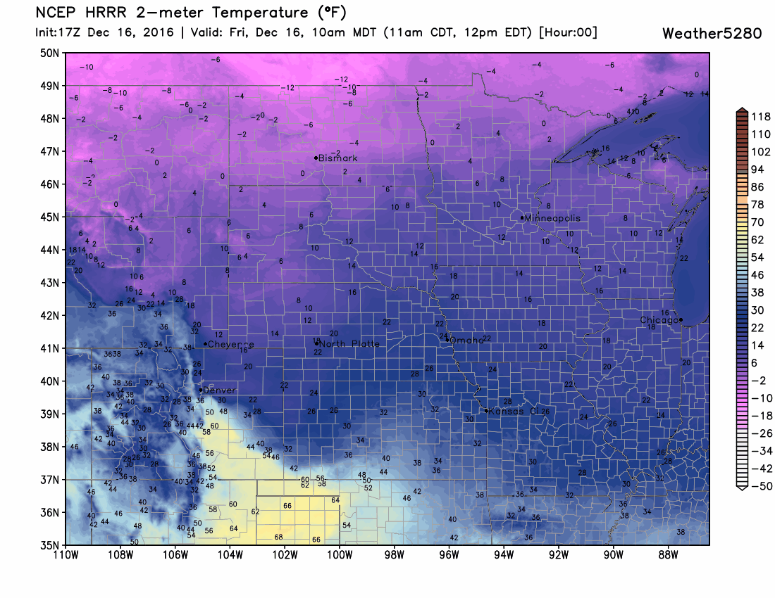
You'll also notice in the loop above a lot of single digits showing up across northeast Colorado. That's where we are headed for Saturday. Tonight's lows may drop below zero, and we won't warm much at all during the day Saturday, with highs in the single digits, and overnight lows into Sunday once again below zero. It could be worse, take a look at those forecast temperatures in Montana tonight!
Anyway, I hope you all are sufficiently prepared for 24 to 36 hours of very cold air, with even colder wind chills. Please stay warm, and protect those pets!
Snow update
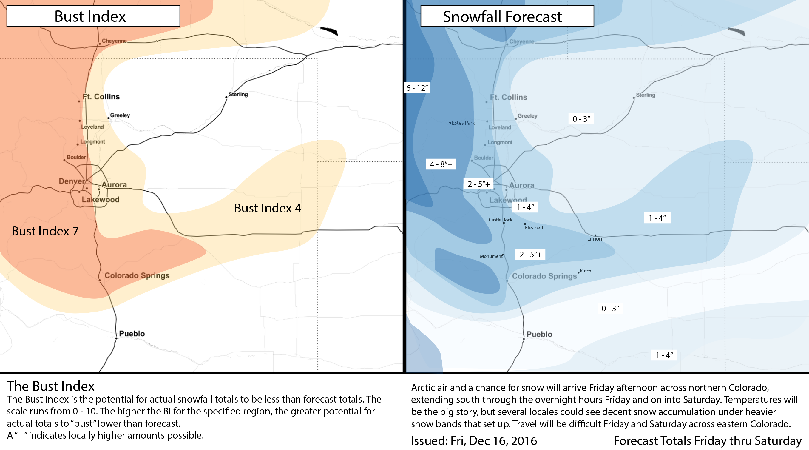
Pretty good run-to-run consistency remains between the models with this storm. The biggest differences remain in where each model places the banded snowfall we've been discussing for several days now. It cannot be stressed enough: if you end up under a snow band you'll likely see several fluffy inches from this system, if you do not, you may very well be looking at a dusting to an inch of snow.
Model QPF looks something like the following this morning. Will give ranges, as picking a point isn't all the representative considering the narrow bands expected.
- 12z 12km NAM (parallel): 0.15-0.25" West of I25, 0.05-0.15" East of I25
- 12z GFS: 0.2-0.25" West of I25, 0.05-0.2" East of I25
- 09z SREF: 0.2-0.25" Fort Collins, Broomfield, DIA, Arapahoe, COS
- 00z EURO: 0.1-0.25" Along/west of I25, up to 0.5" along the Palmer Ridge
- 12z Canadian: 0.2-0.4" Along and west of I25, 0.5-0.6" COS area
It's likely that many of the pockets of >0.4" of liquid are overdone, which leaves the average model QPF somewhere in the 0.2 - 0.25" range, or about 2 - 5" of snow depending on ratios. That said, if a few areas between Colorado Springs and the Wyoming state line see 4 - 7" of snow, I wouldn't be at all surprised, and neither should you. The key is: most areas won't see that much snow.
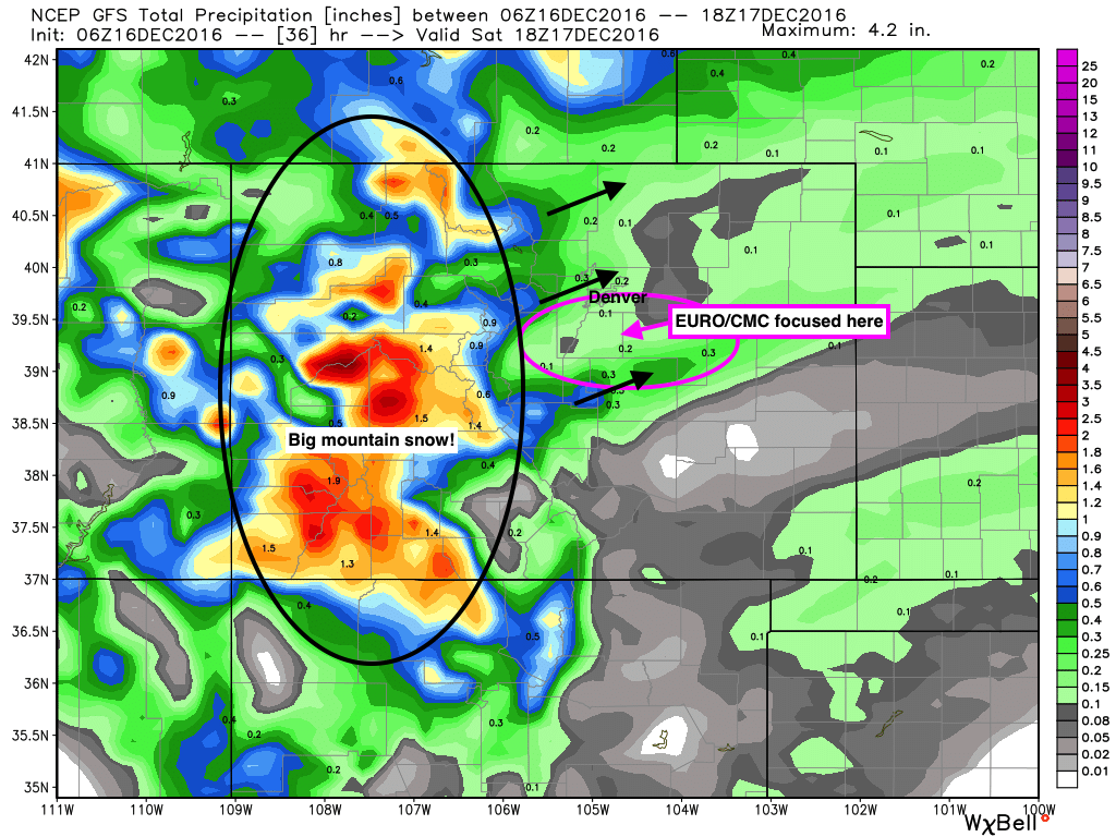
So, where will those heavier bands set up? That remains the biggest question, and an incredibly difficult one to answer. If we look at the latest GFS precipitation forecast, we see really three areas of focus... along and north of Fort Collins, between Denver and Erie (west to Boulder), then the south-side of the Palmer including Colorado Springs (these are the black arrows). The EURO, Canadian, and even the NAM for that matter focus the main band along Denver's southern suburbs and across the Palmer Divide. Needless to say, two very different solutions, each leaving many folks wondering where all the snow is that everyone is talking about... FWIW, the latest run of the EURO produces upwards of 6" of snow for the area circled in pink, while the GFS is driest there.
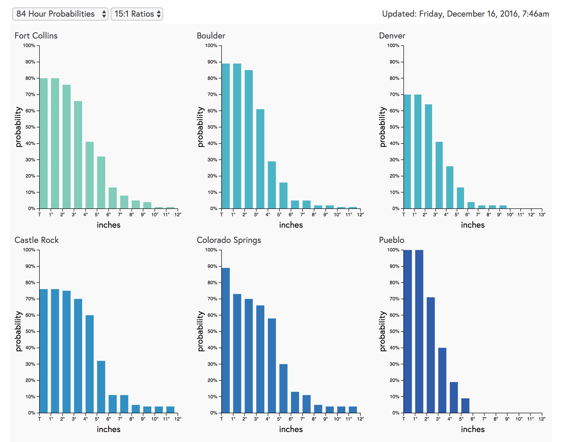
At any rate, we do think everyone sees at least some snow, and hopefully we fully communicate that it'll really be a case of the haves and the have nots, which is hard to draw on a map – yay Bust Index! To that point, however, take a look at our latest snowfall probability charts for the Front Range. Every city shown here has a 70% chance or greater of seeing 1" of snow or more, but those odds start to drop quickly once you get to 3 or 4" of snow. Denver's odds, for example, are about 65% for more than 2" of snow, but only 40% for more than 3" of snow:
With all that considered, here is our latest forecast map, with a few tweaks from what we put out yesterday. Very few changes aside from pulling the 2 - 5" over a bit more of the Palmer to account for the EURO/NAM, and other smaller adjustments.
Timing
As discussed above, the cold has already began pushing into northeast Colorado, so expect those temperatures to cool through the remainder of the day, getting very cold after midnight.
For snow, expect snow showers to build over northern Colorado this early afternoon, then slowly see chances go up across the Denver area and south later in the afternoon, evening, and overnight.
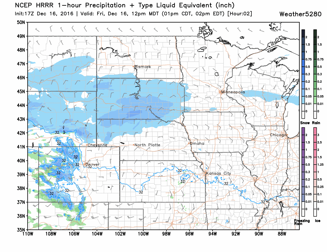
Here's a look at the latest HRRR forecast. Note a lot of heavy snow across the mountains all day (the darker blues) and across Wyoming, Nebraska and extending east. Eventually you see those bands of snow start to push off the mountains and slide south through Denver during the evening/overnight hours. Please be prepared for tough travel conditions as this main snow band pushes through. It may not last long, but for a time this evening, travel will be very difficult as the band pushes south southeast across the metro areas.
We stay VERY cold tomorrow, but snow chances decrease as the day progresses, with perhaps some clearing later in the day. Saturday night will again be below zero for temperatures, warming into the 20s for Sunday.