Snow Band Delivers Biggest Snow of Season for Denver, Tonight It's Just COLD

Well, I hope you had an opportunity to safely enjoy the snow last night, and didn't end up traveling in it or otherwise wishing you were inside instead of out. A great storm for the Denver metro area, and frankly, it's about time!
Overall, I'm not too unhappy with our forecast, although there's really no sugarcoating the bust in the Denver area. We were more bullish than many leading up to last night (which is a change for us!) and despite coming in low with snowfall totals across much of the Denver area, I think we communicated the impacts quite well. First, the dramatic shift to cold, second, the timing with snow arriving with a punch yesterday evening, and third, that heavy banding would lead to tough travel and erratic snowfall totals along the Front Range.
It just so happens that the long-discussed heavy band of snow set up over the Denver area instead of north or south, which is a welcome change. Biggest regret may be that this sentence from yesterday: "That said, if a few areas between Colorado Springs and the Wyoming state line see 4 - 7" of snow, I wouldn't be at all surprised, and neither should you" didn't read 5 - 10" of snow instead.
Ok, so maybe I'll sugarcoat just a little. In the end, always nice to bust high instead of low!
Initially we saw a band of heavier snow develop over the Fort Collins area. This certainly fit the our expectations, dropping about 2 - 4" over the area. Through the evening that band shifted south, developing very heavy snowfall on Denver's north side around 9pm. In the animation below, we see first that heaviest burst of snow push cross northern Denver, but a persistent flow of moisture moving over the same areas. The yellows indicate moderate to heavy snowfall.
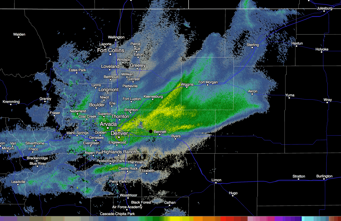
When this band set up, it just didn't move anywhere fast, leading to several hours of heavy snowfall across the metro area. Reports of 1 to 2"/hour snowfall rates (even up to 3"/hr at times) were common with this band of snow. It delivered anywhere from 4 - 8" along and east of I25 in Denver, and 5 - 10" along and west of I25. This just goes to show what a mean cold front and some great jet dynamics can do in just a short period of time around here.
Officially, Denver recorded 8.8" of snow at Denver International Airport. Our station, located just on the south side of downtown recorded 6.5" of snow, with those to the west and north of Denver in the 7 - 11" range, generally speaking.
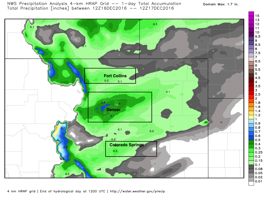
A look at precipitation analysis through this morning shows these snow bands we've been discussing all week very clearly. One up by Fort Collins, our over-performer over Denver, and another one across Colorado Springs and south. The majority of folks from Pueblo to Wyoming saw from 0.15 to 0.3" of liquid, with the Denver metro area being the clear outlier. Kudos, I guess, to the EURO for picking out the potential for >0.4" liquid... but even it had it in the wrong place (over the Palmer, not Denver), and really didn't jump on this until yesterday.
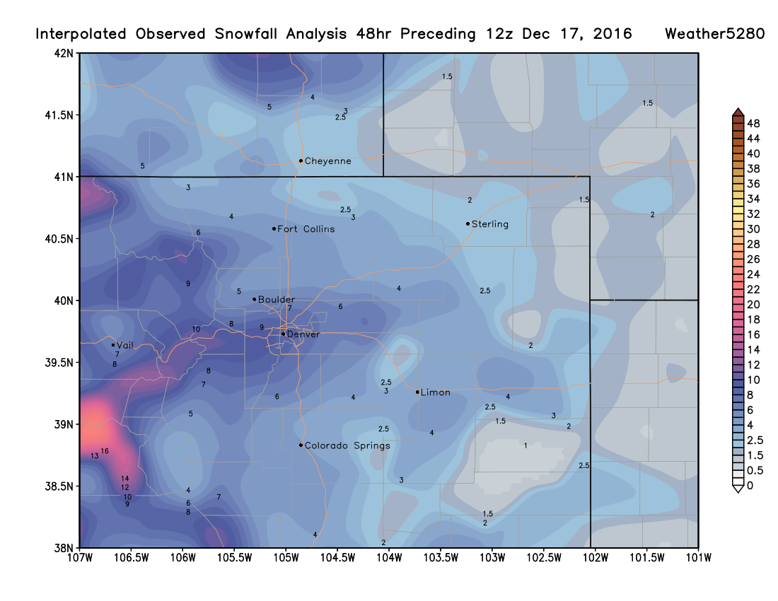
The interpolated snowfall map from across the region shows a similar story. Snowfall forecast mostly on target, except right across the Denver metro area, where totals greater than 6" were most common:
A breakdown of some of the totals from across the region shows where our forecast held, and well... where it got rocked a bit:
| Location | Forecast | Total | Bust? |
|---|---|---|---|
| Weather5820 (Denver) | 2 - 5"+ | 6.5" | 👍💥 |
| DIA (official) | 1 - 4"+ | 8.8" | 💥 |
| Estes Park | 4 - 8" | 8.6" | 👍 |
| Fort Collins | 2 - 5"+ | 2 - 4" | 👍 |
| Loveland | 2 - 5"+ | 3.8" | 👍 |
| Greeley | 1 - 4" | 4.0" | 👍 |
| Niwot | 2 - 5" | 2.7" | 👍 |
| Longmont | 2 - 5" | 2.4" | 👍 |
| Broomfield | 2 - 5"+ | 3 - 5.9" | 👍 |
| Arvada | 2 - 5"+ | 8.0" | 😞 |
| Westminster | 2 - 5"+ | 4 - 7" | 👍💥 |
| Ken Caryl | 2 - 5"+ | 9.0" | 💥 |
| Golden | 2 - 5"+ | 10.0" | 💥 |
| Arvada | 2 - 5"+ | 8.0" | 💥 |
| SE Aurora | 2 - 5"+ | 4 - 6" | 👍💥 |
| Castle Pines | 2 - 5"+ | 6.1" | 👍💥 |
| Colorado Springs | 2 - 5"+ | 2 - 5" | 👍 |
Having a chance to do it again, I'm not sure we'd have changed our forecast. I think lower totals (2 - 5") were the most likely scenario, and jumping on bumped QPF hours before the snow hits around here is usually a sure way to bust on a forecast. As we said all week, models just can't handle these banded snow events, both in where those bands will set up, and in this case also just how slow/persistent they will be.
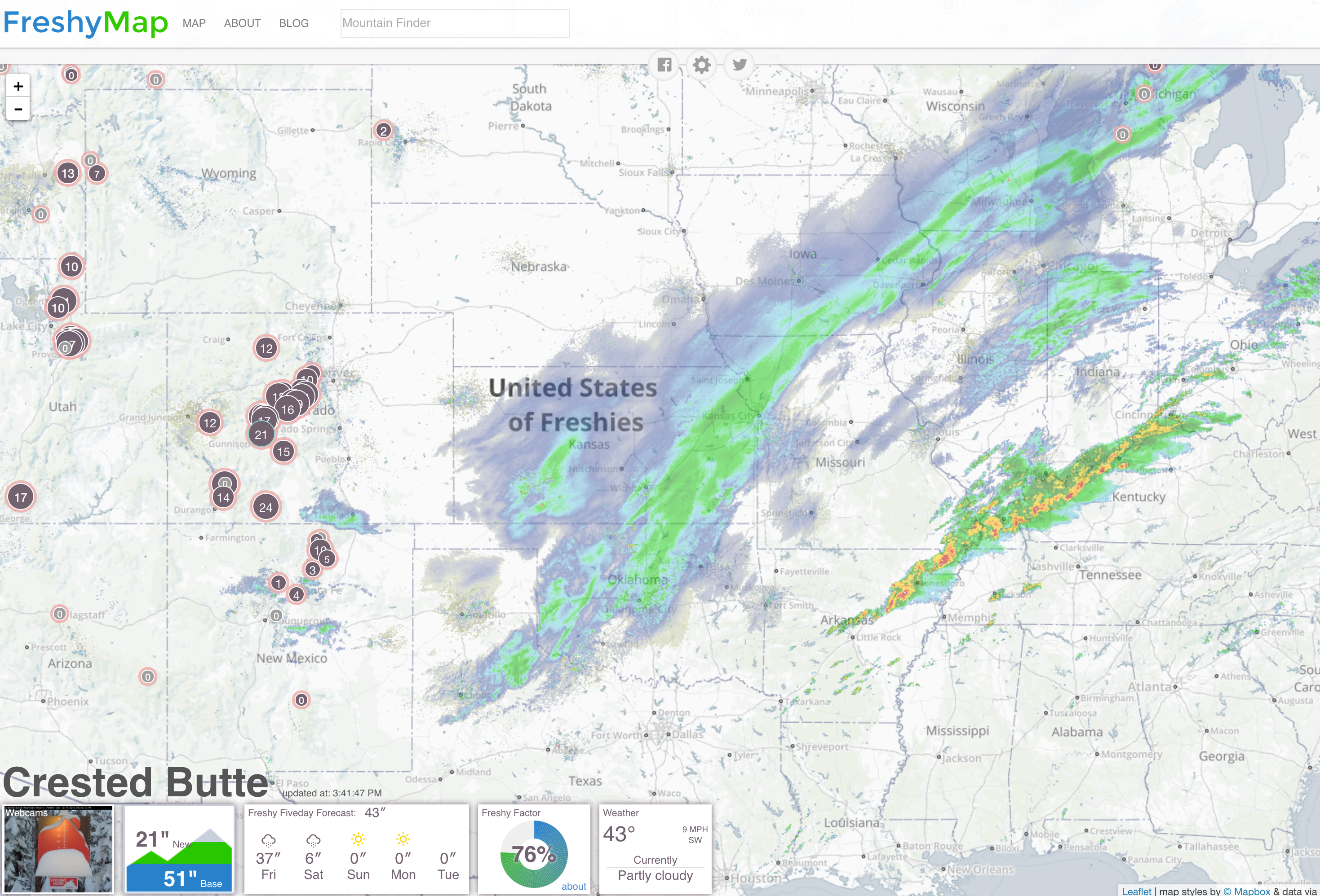
It's also worth mentioning again, this pattern has been GREAT for the high country. With this latest storm, resorts across Colorado are reporting anywhere from 8 to 36" of snow, with 21" at Crested Butte in the last 24 hours alone!
Cold night ahead
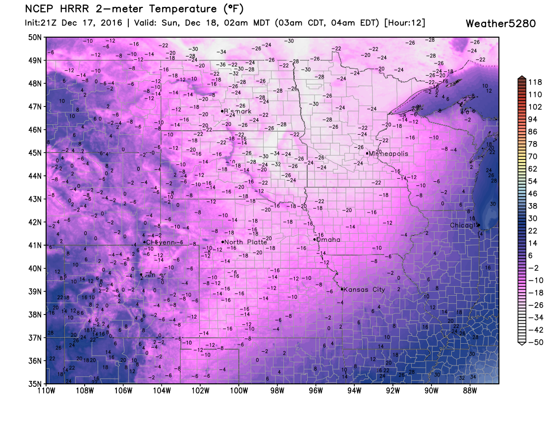
While the snow has cleared out, the cold has not. Denver has been in the single digits all day, and should drop below zero overnight. The record low to beat tonight is -13°F, and while I'm not sure we'll make it, we could get awful close. Latest MOS guidance for overnight lows has temps bottoming out between -5 and -10°F, so if clear skies can last into the early morning hours, we could be flirting with that record.
For its part, the HRRR has us coldest around 2am, with lows from -2 to -15 across northeast Colorado. And, if you think that's cold... check out the temperatures across the Dakotas and Minnesota at the same time. Brr!
We warm up Sunday into the 20s, and will be even warmer Monday. The week ahead looks mostly dry with highs in the 40s and 50s, with the next system to watch arriving next Friday and Saturday to the region.