The State of the Atmosphere: Sunday, January 1, 2017

Happy New Year!
We're still tracking changes for the coming week across eastern Colorado, although the "state" of those changes if you will, is a bit uncertain.
We've communicated the uncertainty around snowfall at length and have suggested that, for some, the cold may be the more impactful event over the next five days or so than the snow. Now there's some question as to just how cold we'll actually get as well.
Interestingly enough, a few days back we were discussing internally that the models seemed a bit overdone with the cold given their forecast teleconnections (ocean-atmosphere connection). While the pattern screamed cold (a tanking EPO and WPO - 2 connections), the lack of a negative AO made us wonder if they might be too cold – especially across eastern Colorado.
We've since seen quite a bit of correction in this arena. And, while the week still looks to feature several days of below average temperatures, it doesn't look quite as epic as once forecast by the models. We think the idea of this correction is correct, though it may possibly be a bit too warm now in some modeling.
Bottomline, plenty of uncertainty remains with the setup for the week and that is true not only for the snow but for temperatures as well.
The week ahead
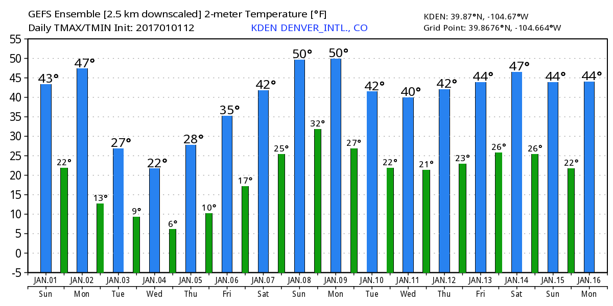
As Bledsoe mentioned yesterday, we should be able to sneak out one more pretty nice day across eastern Colorado on Monday before changes arrive. Forecast highs are in the mid-40s for Denver on Monday, so really not too different than what we saw today for your holiday tomorrow.
By Monday evening we see those colder temperatures beginning to push into eastern Colorado, with a chilly night and the possibility of some snow showers across the region Monday night and on into Tuesday.
Tuesday will be much colder, with highs forecast to remain in the 20s across northeast Colorado, with single digits and teens across the high country.
Wednesday looks very similar, with a secondary push of cold air arriving during the day, and a better chance of snow at lower elevations along with it for Wednesday afternoon and Thursday night.
Beyond Thursday things are a bit "muddier". The GFS operational model has another push of cold air for Friday and Saturday (along with another round of snow), while its ensemble shows us warming. We'll lean with a warming trend to end the week for now, but aren't completely sold on this solution just yet.
As for snow...
No need to hurry on a snowfall forecast. Our main window for the potential for accumulating snowfall looks to be Wednesday and Thursday, and with the amount of uncertainty that remains on how things will set up, it seems prudent to not get too ahead of ourselves.
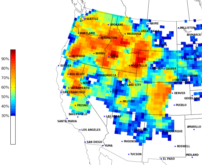
For those keeping score, the models are still VERY generous with moisture over the higher terrain – possibly too much so. At lower elevations, the EURO remains the most bullish with precipitation totals, while the GFS had backed off considerably...until this afternoon.
It's not exactly a textbook setup for those of us at lower elevations. Given the consistency of the EURO and the fact that we saw such good QPF liquid from that system a few weeks back it's hard to completely dismiss its solution.
So, let's see how things look after another few rounds of data come through and go from there. For now, know that the potential for several inches of snow exists this week, but frankly, so does the potential we don't get much at all. Of the top 15 analogs from today's 12z GFS, none of them produced more than 2" of snow in Denver:
Models have a VERY hard time with these setups, and forecasting when and where a band of snow may roll off the mountains is a challenge, especially at range. With several impulses set to impact the state this week, and a few rounds of cold air to boot, we should see at least some snow across the urban corridor before all is said and done. Who knows, maybe snow-lovers get lucky and we see another setup like we saw in December. Stay tuned!