Snow Exits; Cold Lingers Briefly, Then a Warming Trend
With our winter storm that wrapped up later this afternoon, many communities throughout northeastern Colorado saw significant snowfall accumulations, especially in Boulder and Larimer counties. As expected, Boulder proper did especially well, seeing totals around one foot, with higher totals in the foothills. Areas in Douglas and Arapahoe counties fell short, seeing accumulations mainly in the 2-5" range.
This was a difficult forecast, as the majority of the snow was banded in nature due to a 130 knot jet overhead. As we know, these bands can drop impressive amounts of snow in short periods of time over localized areas, which makes these features extremely hard to forecast. Sometimes it is hard to understand that with all of our knowledge and tools, it can be virtually impossible to forecast EXACTLY how and where those bands will set up...despite knowing that they will certainly occur. That is why we ALWAYS try to focus on the overall impact with each storm and convey uncertainty if it exists. Given the complex nature of this storm, we are pretty happy with how things turned out.
Snowfall totals ended up looking like this (note snow later in the day today is not included here for the most part):
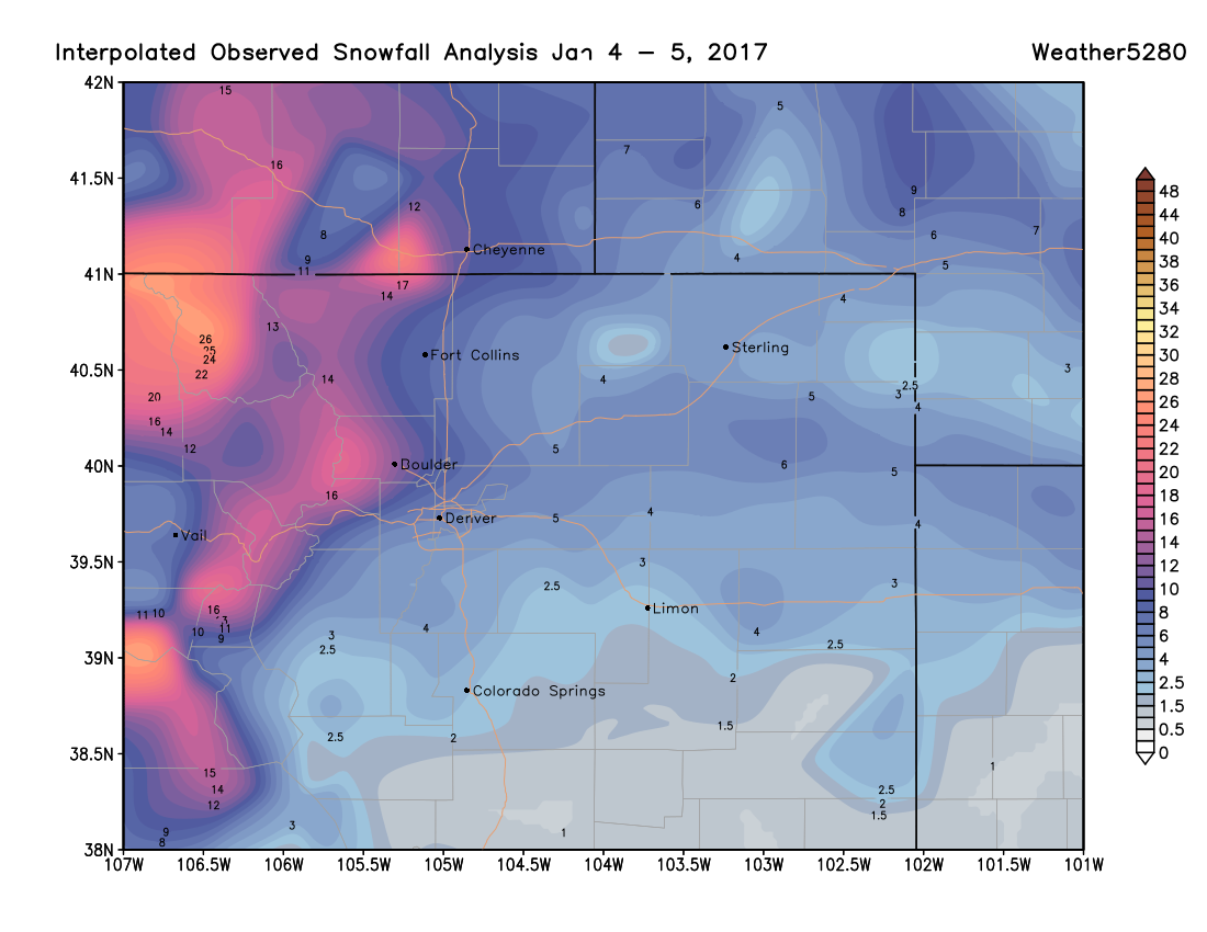
As you can see, the higher terrain did great with this storm, with areas around Steamboat picking up upwards of 30 inches in recent days. Eldora is reporting 22" of fresh snow, with 10 - 25" at most mountain resorts in the last 24 hours.
Here is an interactive map of local storm reports to the National Weather Service through this evening. You can hover over points (or click) for more details.
And finally, here's a list of some totals and our forecast from across the region:
| Location | Forecast | Total | Bust? |
|---|---|---|---|
| Weather5820 (Denver) | 5 - 10"+ | 5.5" | 👍 |
| DIA (official) | 3 - 6"+ | 4.1" | 👍 |
| Fort Collins | 5 - 10"+ | 7 - 9" | 👍 |
| Greeley | 3 - 6"+ | 6.0" | 👍 |
| Loveland | 5 - 10"+ | 6.3" | 👍 |
| Boulder | 8 - 16"+ | 13.8" | 👍 |
| Northwest Denver | 5 - 10"+ | 6.5" | 👍 |
| Highlands Ranch | 5 - 10"+ | 2 - 5" | 😕 |
| Castle Rock | 5 - 10"+ | 3.5" | 😕 |
| Franktown | 3 - 6"+ | 2 - 4" | 👍 |
| Colorado Springs | 3 - 6"+ | 2 - 5.5" | 👍 |
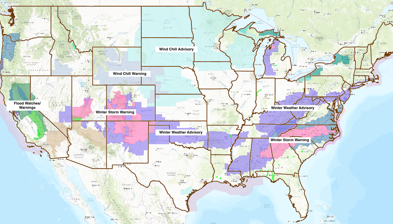
While our snow has come to an end now, snow will continue over portions of southern Colorado into Friday where winter weather alerts remain. In fact, take a look at this very busy alert map from the National Weather Service tonight – from flooding rains in California, to winter across the southeast, to extreme cold across the heartland, we've got it all right now.
Cold tonight, Friday, then warming
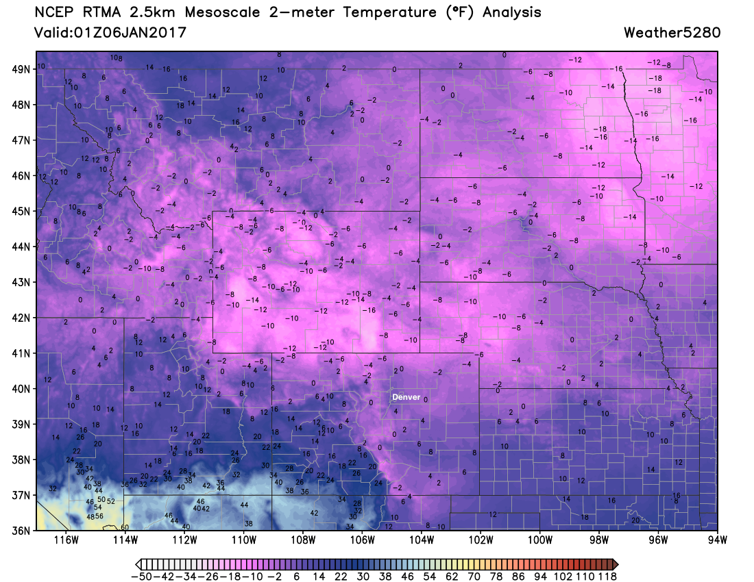
Tonight will be very cold across the region, with temperatures in the single digits now and set to fall below zero overnight. Latest analysis shows cold locked in all around us, with temperatures in the teens below zero right now across Wyoming.
For Friday we'll warm into the 20s (will feel much warmer than today!) with highs expected to climb above freezing on Saturday. By Sunday we'll be breaking out the shorts as highs climb to near 50 degrees in Denver. Enjoy!