Wednesday PM Update: End of Week Chance of Snow

Well, the hype has been building after more than a month without measurable snowfall for Denver. That hype may continue even though a storm is about to slide through the area.
Like a dog waiting for his owner to come home, I sit waiting for a snow to get excited about. This isn't it, so I'll just fall asleep by the door and keep waiting.
The storm coming in is developing to our west tonight. As this trough develops the prevailing flow will lift it toward the northeast over Wyoming and Nebraska Thursday and Friday. These areas may have a foot or two of new snow and travel will be tough along stretches of I-80.
That kind of snow hasn't been seen in Denver once this season (we did have more than a foot last March the 23rd). And, unless this storm should suddenly drop 200 miles south we won't see much this time around.
The outlook
The mountains will again have some decent snow. Larimer and Weld County stand a chance of accumulation too. These zones will have the best coverage of heavier snowfall. Move southward into the Denver metro area and over the Palmer Ridge to Colorado Springs and we will likely only have isolated/scattered chances for snow (rain is briefly possible). This animation of one particular model will demonstrate that coverage of snow, and isolated areas of rain (thunder can't be ruled out too):
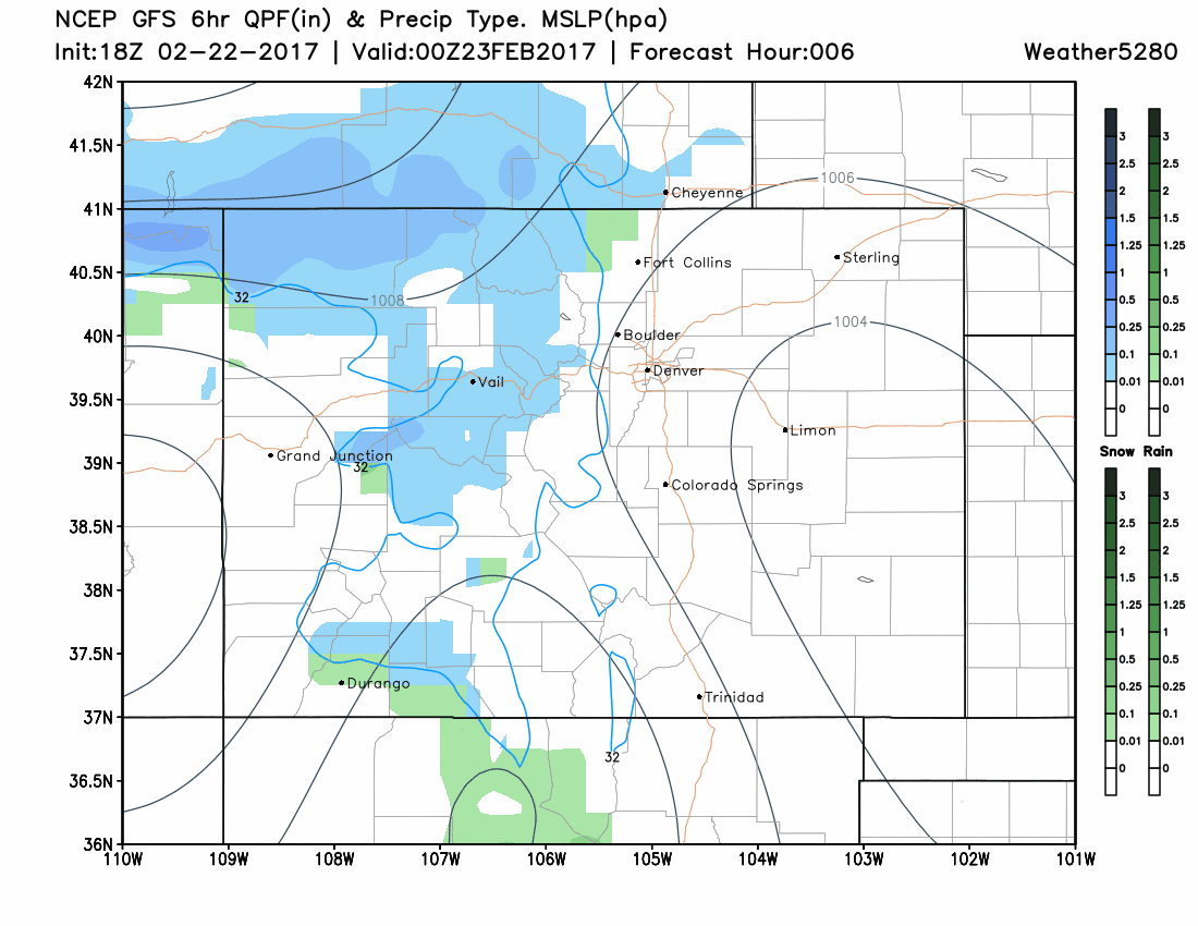
Denver's chances of snow begin Thursday morning, however, the better chance will hold off until Thursday night and Friday morning. Chances continue through Friday night as we remain unsettled.
Amounts
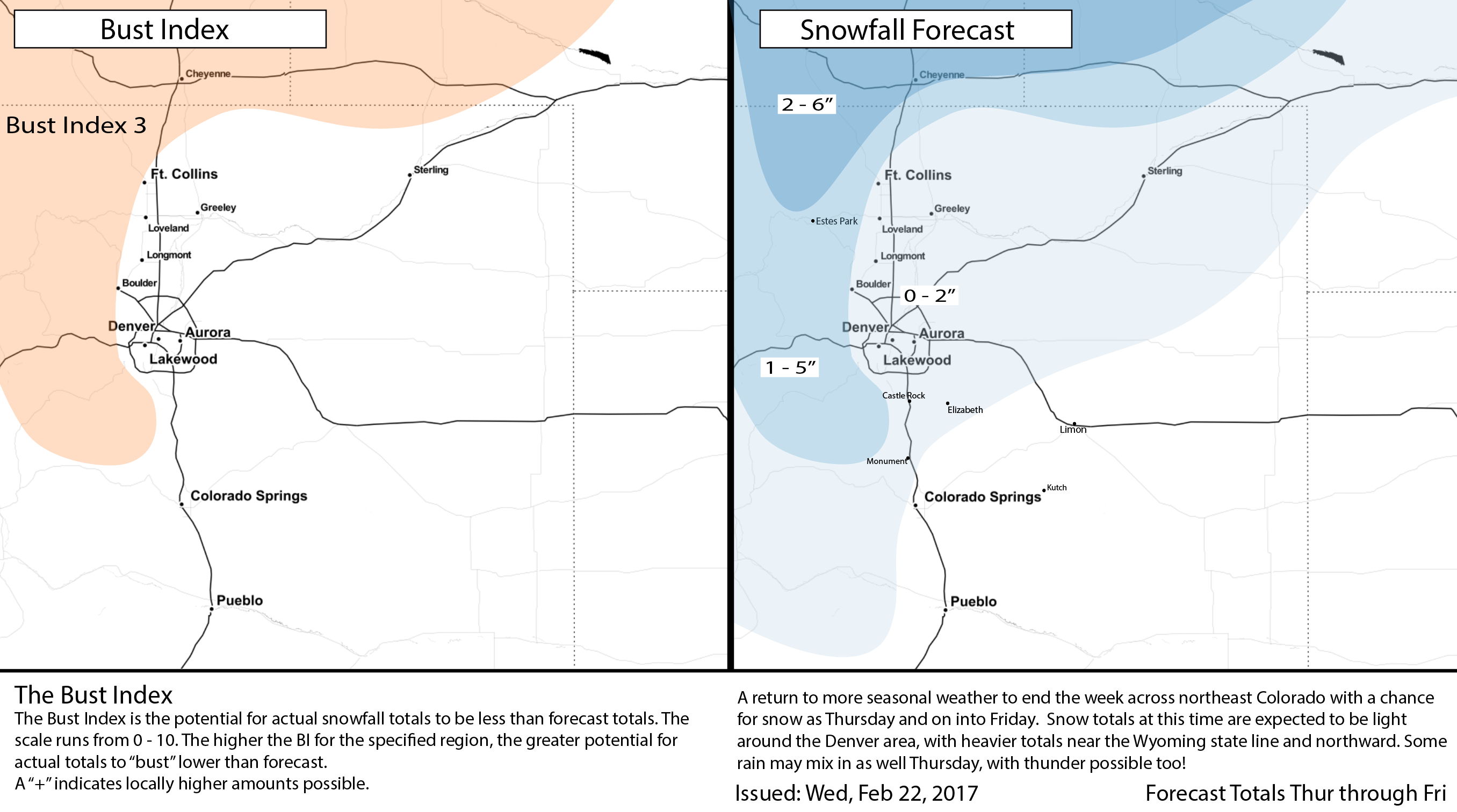
Given the better coverage of snowfall will be in the mountains and across northern Colorado that's where we will find the shovelable snowfall. Denver, however, we aren't expecting a shovelable amount. 0-2" is expected in the urban area with 2-5" possible in the foothills and across extreme northern Colorado. Again, this is based on the current path of the storm and should it shift south even a few miles a heavier amount of snow will be possible near Fort Collins and Wellington. This chance is indicated in the Gambler Charts.
For example, Fort Collins has a probability of some higher totals than say Boulder to account for any shift in an eventual storm track.
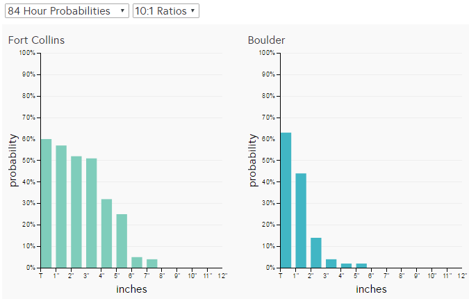
Using the probabilities we've fit the snowfall accumulation to look like this:
Travel Impacts
With any rain and snow shower there is clearly going to be a travel impact, but outside of minor events, the major focus for transportation officials will be I-70 and the mountain highways, I-25 north of Fort Collins, I-76 toward Nebraska and our neighbors in Wyoming and Nebraska will have some serious impacts – namely I-80.
Temperatures
Temperatures will likely come away as the big talking point with this passing system. We've had a run of the 70s and even an 80 over the past few weeks and that has put this February into the top ranks of hottest ever for Denver. Don't count your chickens before they hatch, though, as we will be in the 40s Thursday, 20s, and 30s Friday, and as cold as 10 by Saturday morning. Most of the rest of February will be near to below average so that current 'hot rank' for Denver will be dropping the next week.