Thursday PM Update: Quick Shot of Rain and Snow to End Week

Another afternoon of warm temperatures across eastern Colorado ahead of our next change in the weather. Temperatures at noon were in the mid-70s along the Front Range – and, while not record territory, close to – with Denver's record high for the date sitting at 80°F, set in 2016.
As Matt mentioned in this week's State of the Atmosphere, this next system won't be a big change for us, but a change nonetheless.
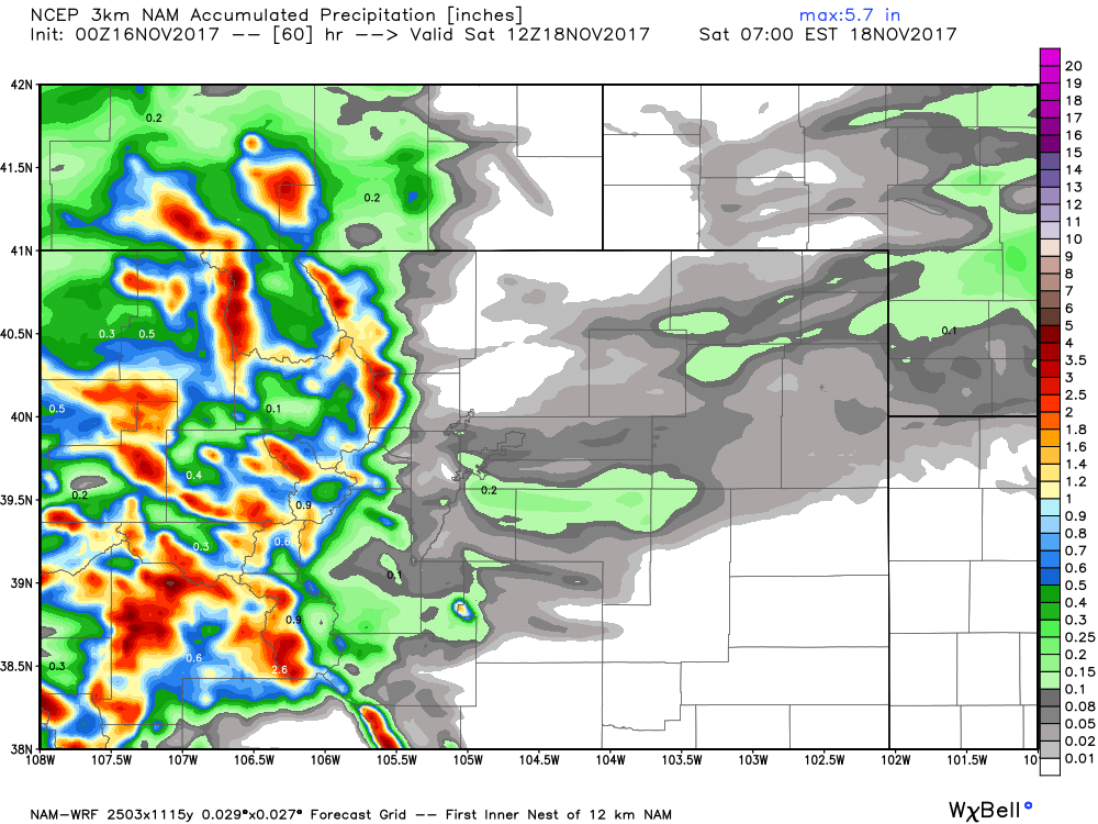
First impacts will be felt in the mountains, where winter storm warnings and weather advisories are up for most of the high country. Snowfall totals will vary greatly, with upwards of 2 feet possible across the highest terrain of the north-central mountains. Snow is forecast to increase through the evening today, and continue off and on through Saturday morning.
At lower elevations, we'll also see some wet weather move through but our numbers won't be nearly as impressive. The best chance of rain and snow along the I-25 urban corridor and eastern plains come Friday and Friday night, with sunny skies back in the forecast for Saturday.
Since we're not dealing with too tremendously cold air (especially for this time of year) we're likely to see any precipitation that does fall during the day Friday to fall in the form of rain at lower elevations. As temperatures cool Friday evening, rain will change to snow.
As for totals... both rain and snow amounts will be pretty light east of the mountains.
For total precip (much of that falling as rain) look for totals in the Trace to 0.2" range east of the mountains. The focus of that moisture may end up across the Palmer (as the second image suggests below), but we'll go ahead and broad-brush the entire Front Range with the chance for rain/snow showers Friday and Friday PM. As you can see, the greatest moisture will get locked up in the hills to our west:
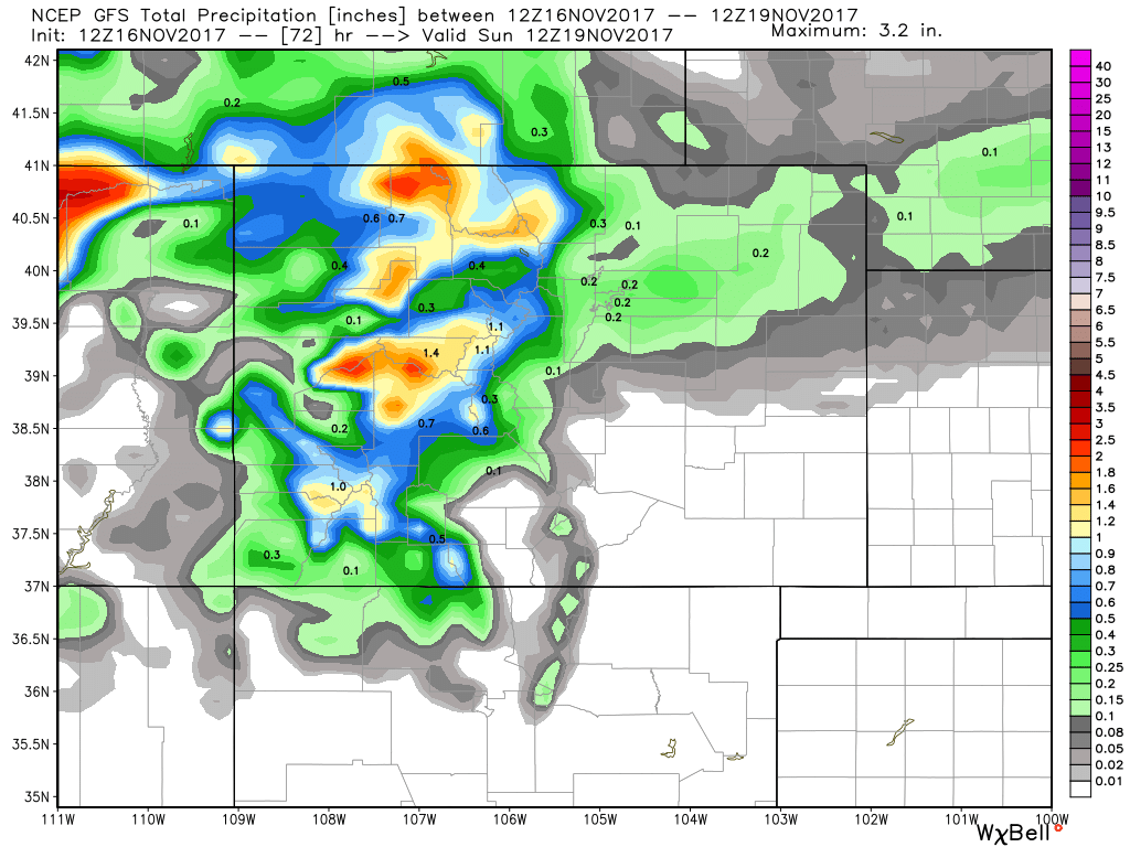
For snow we're not expecting much to accumulate down low. Denver will be in the 0 - 1" range (likely closer to 0"), north of town similarly, though probabilities will be even lower there for accumulation. Best chance for a couple quick inches of snow Friday PM will be up against the foothills and south of Denver/north of Colorado Springs across the western Palmer Divide. These areas could see a push of heavier snowfall and a quick 0.5 - 3", at least locally. Down the other side of the Palmer, we're not expecting any snow to accumulating in Colorado Springs either.
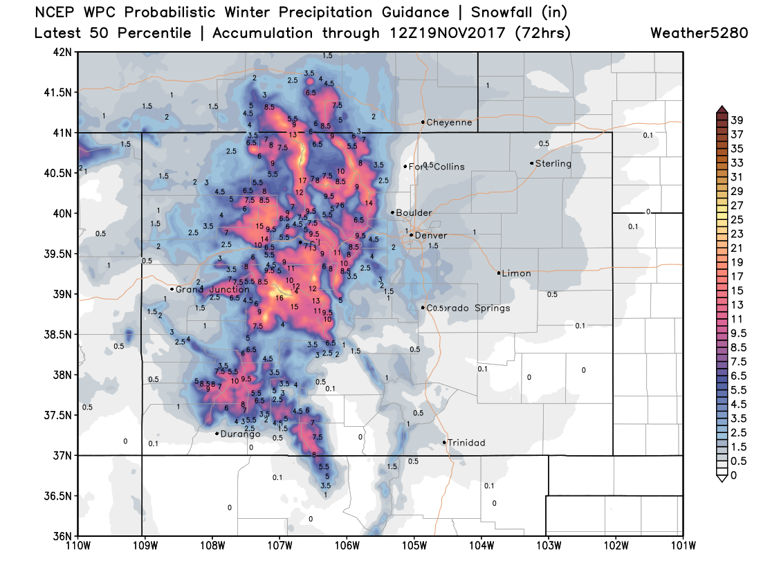
The below snow map matches our thinking. Some GREAT mountain snowfall (they need it!) with not a whole lot going on across the eastern part of the state.
As for travel impacts. Expect tough travel conditions if you are heading west from this afternoon through Friday night. Our greatest concern for the metro areas will likely be after sundown Friday, where we could see a bit of icing as rain changes to snow / mixed precip falls. Again, those areas at just slightly higher elevation as compared to say Denver will be at greater risk for some slick spots on the road, so if you commute between Denver and Colorado Springs or up into Golden and Boulder, please take care.
Temperatures will cool a bit for the weekend as compared to recent days, but dry conditions will return. Highs in the 50s look to be the general consensus for early Thanksgiving week, with a bit of a question mark as we head late into next week.