Thursday PM Update: Weekend Starts Mild, Ends Cold

Friday 10/12/2018 update: Weekend Snowfall Forecast Map
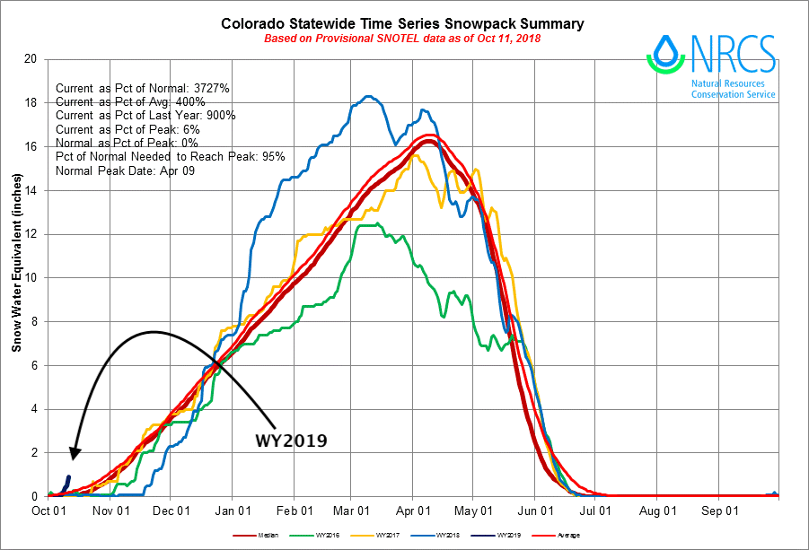
It's been a great week or so for snow across the high country, with a sharp up-tick in snowpack in recent days, and more snow on the way. So good, in fact, that Wolf Creek Ski Area will open for weekends starting this week after 20" fell on the pass this week. This is now the quickest start to snowpack we've seen in a few years, and nicely above average for the date:
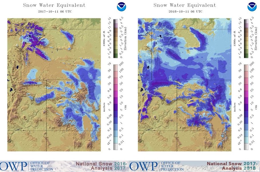
If we compare the SWE map from this day last year, a notable increase of snow coverage across Colorado, Utah, and Wyoming:
More snow is in the forecast through tonight for the central mountains, with areas like Vail and Aspen looking to pick up another 3 - 6", with locally 12" possible.
Great news indeed as our mountains struggled mightily last year. Is this a sign of things to come? Hard to say. We do see the ridge fighting back a bit after this weekend, so let's have the mountains pick up as much snow now as they can in the meantime. Easy to imagine another below-average season up high, but hard to imagine it being as bad as last year.
Weekend storm
While many locales along the Front Range saw their first flakes yesterday (even some big ones in downtown Denver!), it for the most part didn't amount to much east of the foothills. Boulder saw just under an inch, with a few other areas picking up a quick dusting as well. At our station, despite the official first snowfall having come and gone, and yesterday's first snow for many... we still haven't measured anything to date.
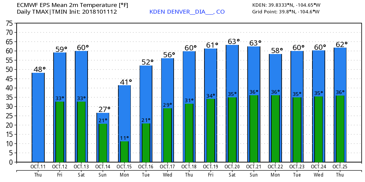
The weekend storm has the potential to bring the first widespread accumulating snow to the urban corridor and much of eastern Colorado. Before then, look for moderating temperatures and a nice end to the week across the plains. Highs both Friday and Saturday are forecast to be near 60 in Denver, before the front arrives mid to late day on Saturday.
Still some uncertainty around how much snow to expect this weekend. What looks more certain is this will be a very strong cold front that will affect the region, with highs tumbling from near 60 midday on Saturday to only the mid 20s (and falling) on Sunday in Denver. Overnight lows Sunday night into Monday will be in the teens.
Behind the front good upslope flow will develop, and with it a good chance of rain (perhaps briefly) then snow from Saturday evening through midday Sunday across eastern Colorado.
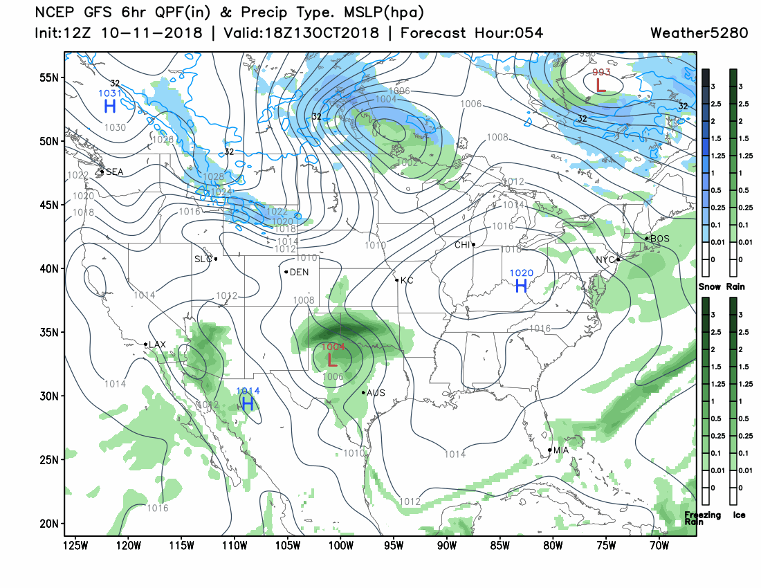
With upslope flow near the surface, and the jet roaring up above, expect to see some banded snowfall develop overnight Saturday into early Sunday. Models will struggle with where to place the heaviest snowfall up until the event, but worth noting we'll see a varying range in totals from the Cheyenne Ridge, south through the metro area, across the Palmer Divide, and eventually across southern Colorado and the eastern plains.
Right now there's a lot to like about the EURO forecast for Denver. Both its ensemble mean and control run are around 3" for the city, with about 1.5" for Colorado Springs (which likely will deal with downsloping off the Palmer Divide and could limit snowfall there), and closer to 4" for the northern Denver suburbs (pinpoint Broomfield). It's been very consistent in recent days, and has good model support from other models as well.
If we look at the same probabilities we looked at earlier this week, we see greater confidence now in the lower end totals, and growing confidence in the medium range totals.
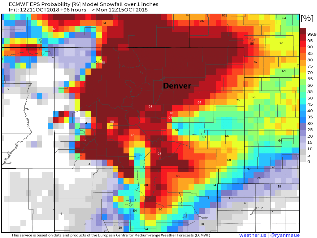
For 1" of snow or more:
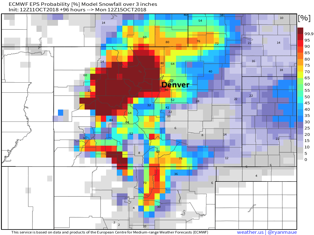
For 3" of snow or more:
For 6" of snow or more:
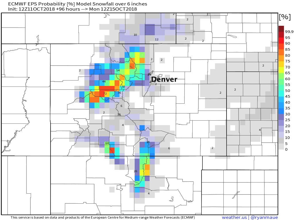
A couple of notes here... starting with pretty good odds from the EURO most of northern Colorado sees an inch or more of snow this weekend. Second, good odds for Denver, and areas along and west of I-25 heading north to see at least 3" of snow this weekend. Third, not great odds for anyone outside of the mountains to see more than 6" of snow through the weekend! And lastly, pretty clear the EURO thinks those on the south side of the Palmer south of Denver will see downsloping limit snowfall totals –– just a COLD northerly wind.
At the moment this feels like a 2 - 5" event for Denver, with maybe 3 - 6" or even 4 - 7" for communities west of I-25 along the Front Range. Certainly time for that to change between now and Saturday night, but barring any big changes we should end up somewhere in this ballpark when we issue our official forecast. Of course one consideration this time of year is the old "what falls vs what sticks". Despite the cool week, ground temperatures are still pretty warm coming off the summer. so a good bit of what falls will be melting pretty rapidly. Always an extra twist to trying to forecast "totals" this time of year...
TL;DR
- Some rain showers are possible through the remainder of the day, but shouldn't be a big deal.
- Friday will be the nicest day of the week, with highs near 60 for Denver.
- Saturday starts mild, but we may see daytime highs early in the day as the cold front moves into northern Colorado likely Saturday morning, then through the metro area by afternoon.
- Upslope flow and very cold temperatures are forecast behind the front bringing the first widespread snow event to the Front Range/I-25 corridor this season. Expect travel to become difficult late Saturday night into Sunday across eastern Colorado.
- Several inches will be possible with this storm, details to follow.
- Sunday snow tapers off gradually from north to south, with COLD air in place through Sunday night.
- Highs are likely to be in the 20s Sunday, falling into the teens as the day progresses.
- Milder weather in the forecast next week.