The State of the Atmosphere: Sunday, November 25th, 2018

Well, that was a heck of a way to pick up a 1/2 to 1" of snow last night, wasn't it? With gusts to 60mph, the snow that moved through Saturday evening was impressive –– albeit short-lived. Fair to say blizzard conditions were experienced across much of the urban corridor for a time last night before the heaviest snow and strongest wind shifted east. The literalists among us will tell us this wasn't the true definition of a blizzard, but a wild hour or so nonetheless.
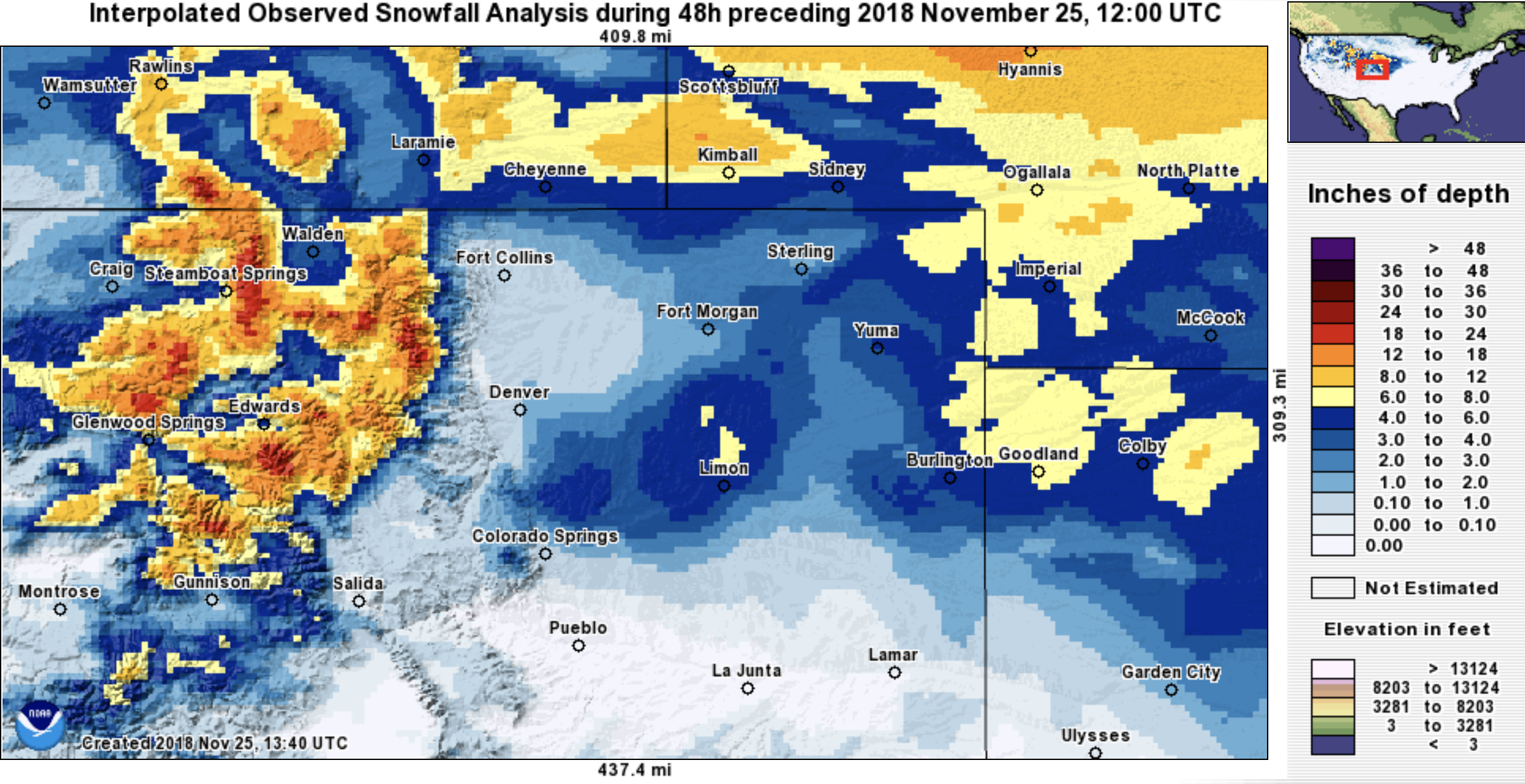
Most of the urban corridor saw less than an inch of snow last night. Denver International Airport picked up 0.7" of snow, bringing the official seasonal snowfall total to 6.7", about half of where we should be at this point in the season. On Denver's east and southeast side a few 1 - 3" totals were reported as the heaviest band moved down I-25 then slowed a little as it came up against the Palmer Divide. Well east of the city we saw some pretty good totals too, with a few 6" reports north of Limon and again along the Kansas/Nebraska border. Of course, the biggest story of the weekend was in the mountains, with upwards of two feet of snow reported at many mountain resorts over the last three days. Here's a look at 48 hour snowfall totals across northern Colorado as of this morning:
The week ahead
The next seven days looks very much like what we've seen for the last several weeks. A warming and drying trend to start the work week, with more active weather set to return by later in the week and next weekend.
Current MOS guidance has the warmest day of the week coming on Wednesday for Denver with highs near 60 across the region. Monday and Tuesday won't be all that bad either with temps in the upper 40s and 50s with mostly sunny skies.
Wednesday and Thursday both show a more active pattern returning to the high country, but are likely to remain dry across the plains. Westerly flow with embedded energy may lead to an uptick of snowfall once more up high, however.
By Friday and Saturday our focus turns to a more organized trough that will move into the west. This one is (at least at range) presenting itself with perhaps a better track for us as compared to last night's system.
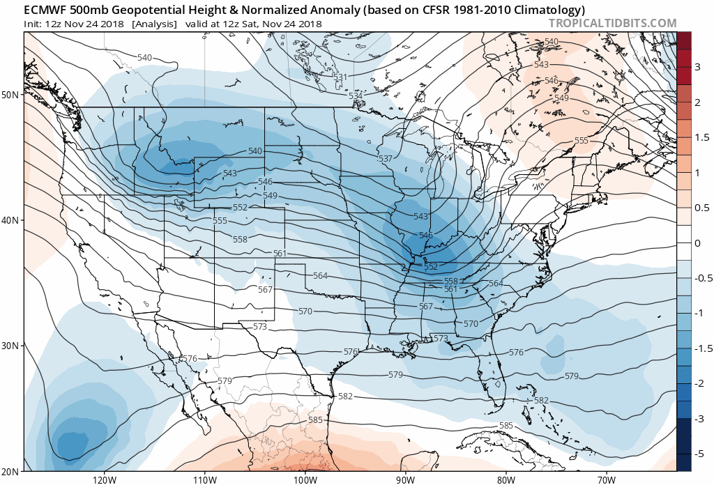
If we look at yesterday/last night's system, we see it dive out of the northern Rockies, into Northern Colorado, then dropping into western Kansas this morning and intensifying. It then skirts east, delivering blizzard conditions across the upper midwest through tonight:
This track just isn't all that favorable for snow along the I-25 urban corridor. We see that a strong surface front can overcome some downsloping off the mountains and still produce some snow, but even with all the excitement last night... not all that impressive from a snowfall perspective.
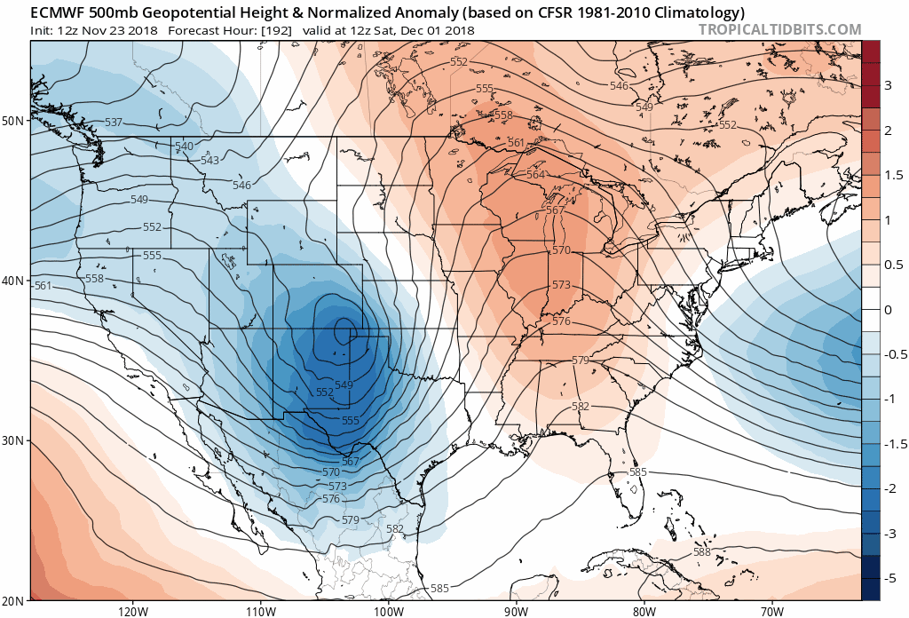
Our late week system instead will move into northern California on Thursday, then into the Great Basin Friday, eventually tracking south of Colorado and into the Plains by next weekend. If we look at the last three forecast from the EURO at 500mb below, we see a pretty different look overall as compared to what happened this weekend. For one, there is ridging to the east that may help slow this next system down a bit. What we also can note is that the last three forecasts have the low centered much further south (and at times west) than the system that moved through last night. Yesterday's run with it over southeast Colorado, then northern Texas, and today a broad circulation centered over the Texas/Oklahoma panhandles:
It'll be very interesting to see how this system evolves. Right now it doesn't really appear to get its act together until it moves into the plains states east of Colorado, much like the system that intensified east of us today.
Models aren't in great agreement overall, but are more so aligned today than yesterday with the evolution of next weekend's trough. That said, the Canadian and GFS are both more progressive with the trough than today's 12z EURO, have less ridging east, and leave a bunch of energy behind where the EURO is trying to cut the low off and at least looking somewhat interesting. If the GFS is right, it's possible that it's actually the following trough (early next week) which would be the one to watch. Which solution we'll begin to converge on over the coming days is anyone's guess, though as I suggested above... a more progressive/faster/disorganized system with minimal impacts east of the mountains in Colorado is probably favored at this time.
The uncertainty is reflected between models, but also with a large ensemble spread as well. Take a look at the latest GEFS forecast. Top graph shows temperatures with the spread between its 21 ensemble members, bottom shows 6 hour precipitation totals for each ensemble member (y axis). Note the good agreement between all members that we will be pretty dry to start the week, and warming. As we move into late week and next weekend, a general cooling trend is indicated, as well as some precipitation... but the temperature spreads get pretty big, and there aren't any real clusters (agreements) in precipitation for Denver anywhere to be found. It looks unsettled next weekend more than anything else.
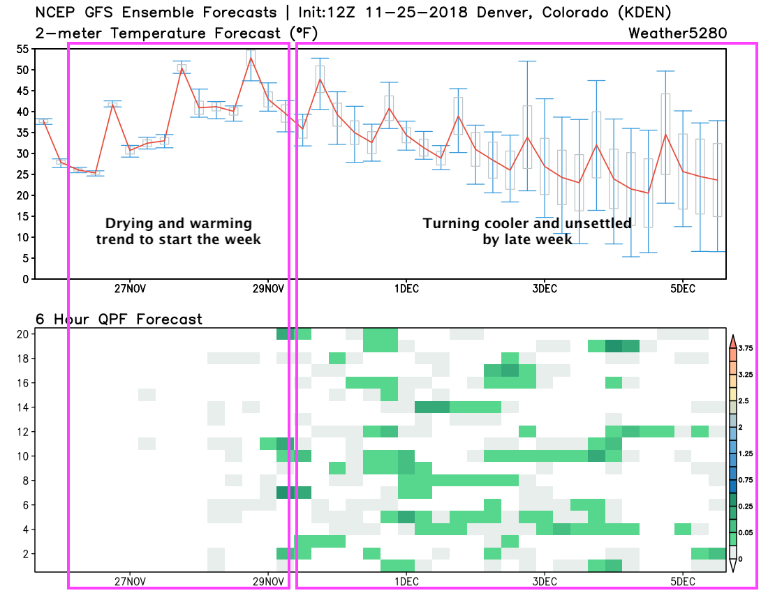
The long and the short of it is... I could very well see Denver coming out of the next 15 days with very little (no?) snow (perhaps another quick hitting inch here and there), or getting lucky if on of these systems from a very active storm track across the United States if one ends up deepening/slowing just enough to give us a chance.
Similar to what we said last week in anticipation of this weekend's storm, we'd generally like to see the some more teleconnection support before getting too excited about our prospects for snow. A look at the latest PNA forecast shows it perhaps dipping negative by late in the week... but will that transition be enough? It's often when the PNA transitions from + to - or vice versa that we can catch a good storm around here. The question is if that is enough of a dip negative in this case...
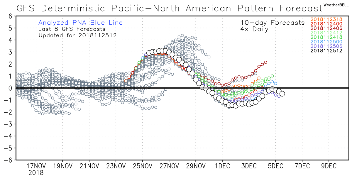
Bottom line is the upcoming pattern usually equates to what we saw yesterday: more bark than bite along the Front Range. I'm intrigued enough by next weekend's system to keep an eye on it as we head into the work week. There are several more waves behind it as well, with this active pattern nationally spilling into December it appears.
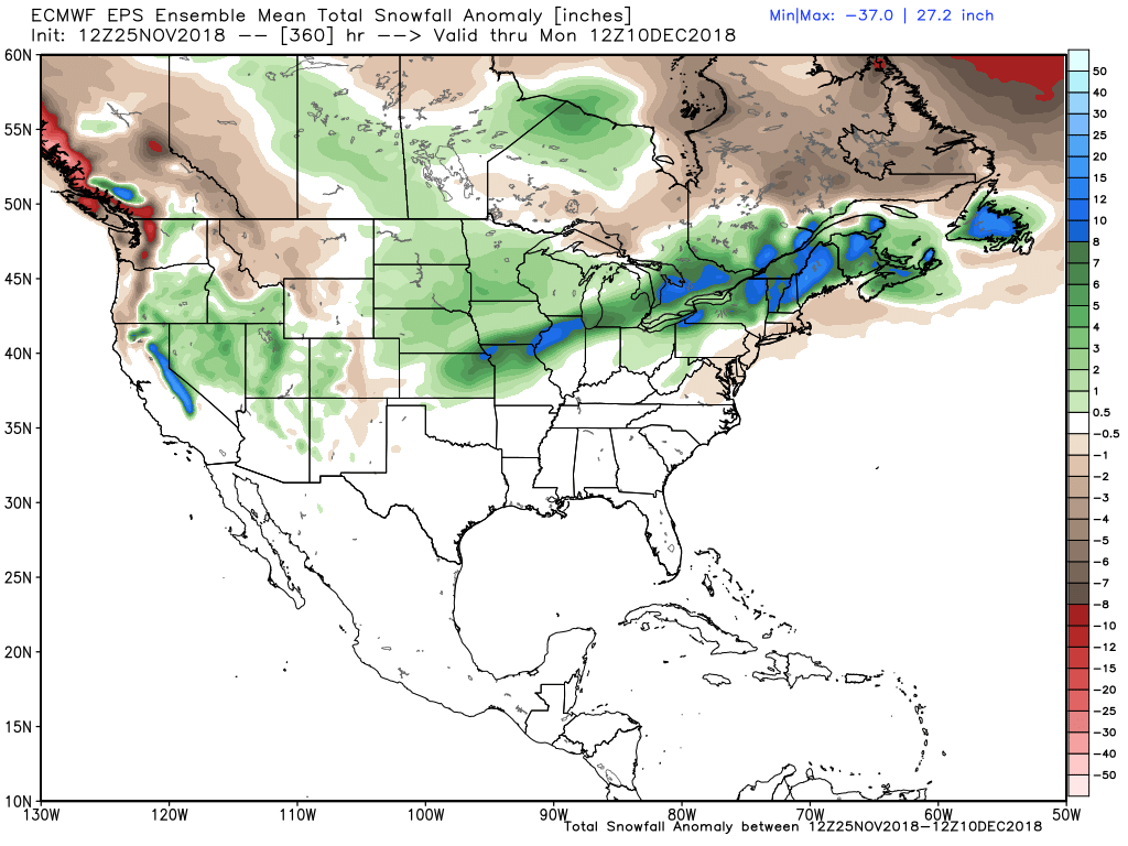
FWIW, the EURO ensemble mean forecast unfortunately agrees with this. Its 15 day snow anomaly forecast shows above average snowfall for western Colorado, but below average snowfall along the Front Range. Good thing it's often wrong :)
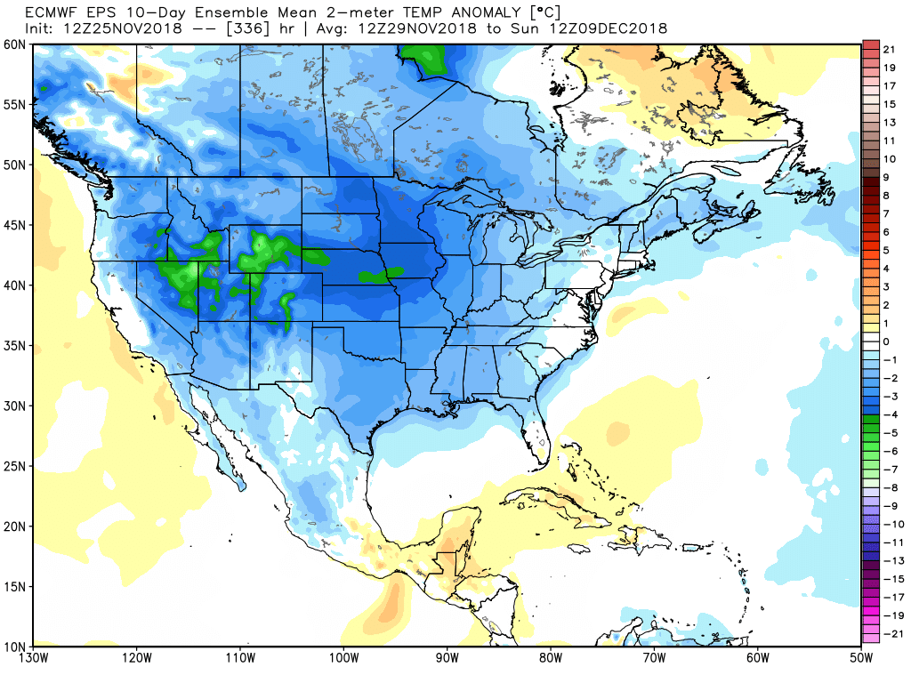
Snow or no snow it insists on a cold start to December. Here are the 10 days preceding December 9th in today's morning run... coast to coast cold.